BLUF
A series of fronts will be working through the state over the next several days bringing some chances of moisture in the next 48 hours and a bit of a rollercoaster ride in temperatures. Temperatures warm back up and rain will be possible in south central and eastern Nebraska later next week. Next weekend looks unseasonably warm and near-record warmth will be possible to start the week of the 27th.
Front #1
A look at 500-mb heights reveals a deeper trough over the Rockies with a ridge in place around Branson, MO. This is helping bring abnormally warm and humid conditions to the eastern half of the state with southerly winds. Western Nebraska is closer to the base trough and is on the other side of the cold front, with much cooler conditions and winds out of the north.
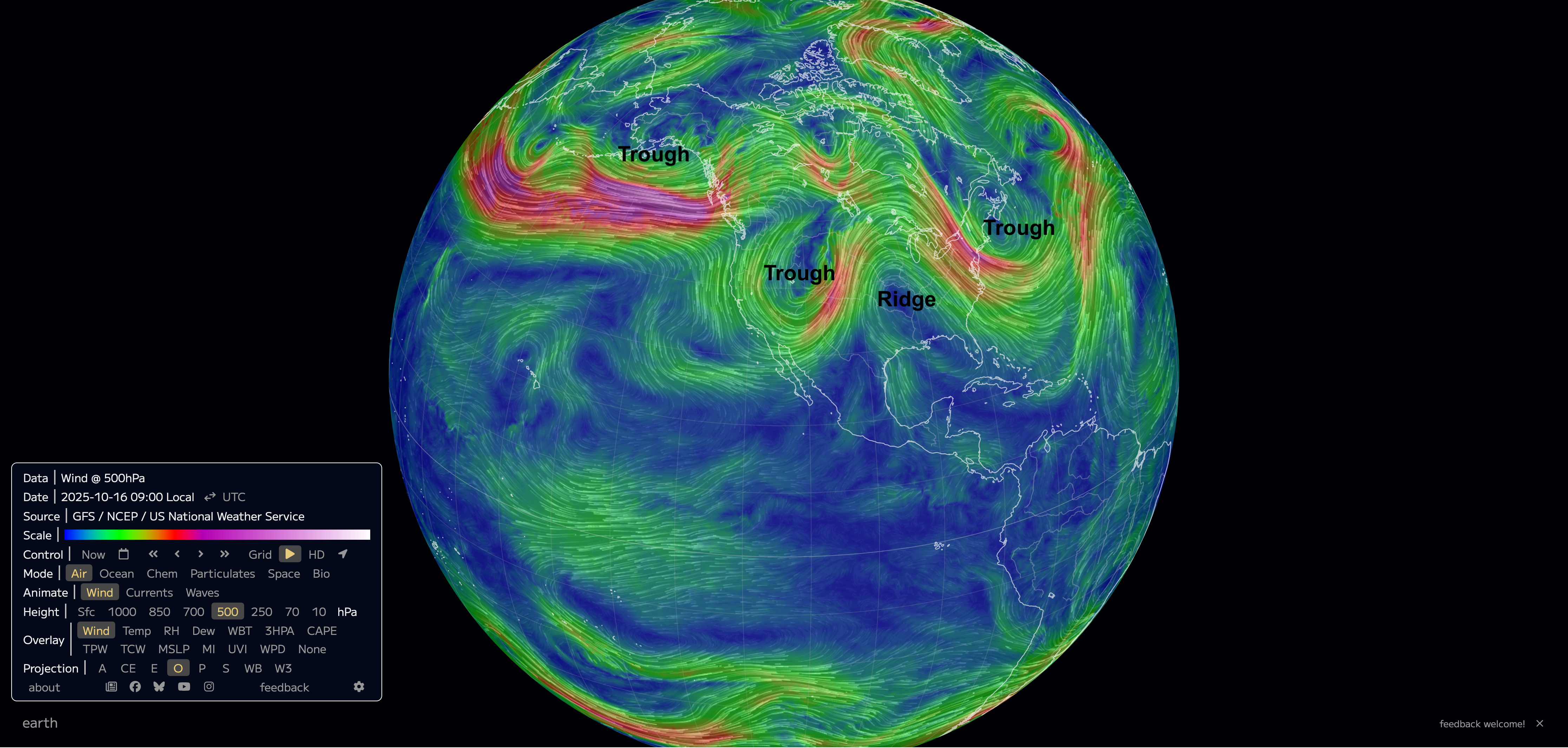
Figure 1. 500-mb heights
The front will be the focus for showers and storms over the next 24-30 hours, with significant precipitation possible across west central sections of the state. Precipitation will be probable in central Nebraska overnight into tomorrow morning across the eastern third of the state. Amounts over half an inch may be possible in isolated spots but generally amounts will be under a quarter inch in eastern Nebraska.
Front #2
The trough that is currently in the Gulf of Alaska will be entering the north central U.S. by tomorrow night. At the surface a cold front will be moving through the state, which will bring a chance for showers followed by cooler temperatures. The current projection is that the front will clear most of western and northern sections of the state by Saturday morning with most of southern sections of the state being in the warmer sector. There is likely to be a 20-30°F temperature gradient within 100 miles of the front on Saturday afternoon. An earlier arrival of the front would mean places like Omaha and Lincoln will be in the 50's on Saturday afternoon instead of pushing 70. Precipitation along the front is not expected to be significant but a brief downpour with wind will be possible. It also will be breezy from the northwest behind the front. Temperatures on Sunday morning will be seasonally cool with frost likely for most of western Nebraska but should rebound nicely in the afternoon to the 60's and lower 70's.
Front #3
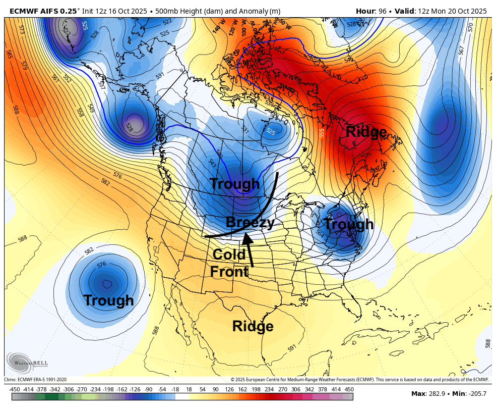
Figure 2. 500-mb height anomalies Monday morning
Another front will move through during the day on Monday but is likely to come dry as there won't be that much moisture to work with. The WPC shows no precipitation for the state with the frontal passage. As with Saturday's front, the timing of the passage will be important. Temperatures will cool off back to the upper 50's and lower 60's behind it with temperatures possibly getting into the 70's in southern sections of the state. It will be breezy from the northwest behind the front. Sub-freezing temperatures will be possible in central Nebraska on Tuesday morning and likely in western Nebraska. It will be a tad chilly in eastern sections on Tuesday morning but a freeze is a lower probability event.
Figure 3. Projected precipitation from the WPC
Late week rain chances
Ridging will start to come back into the central U.S. by mid-week bringing warmer temperatures in by Wednesday and Thursday in the upper 60's to lower 70's. By late Thursday, we may be seeing precipitation chances increase for at least south central and southeast Nebraska as an upper level and associated shortwave energy moves into the southern Plains. At the present time the best chances for picking up significant moisture look to be to our south and southeast. But a more northeastward track would give the eastern half of the state a better shot at over half an inch with better chances of some moisture in the western half of the state.
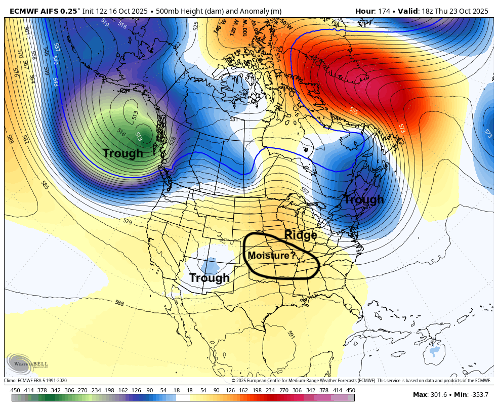
Figure 4. Projected 500-mb height anomalies on Thursday afternoon
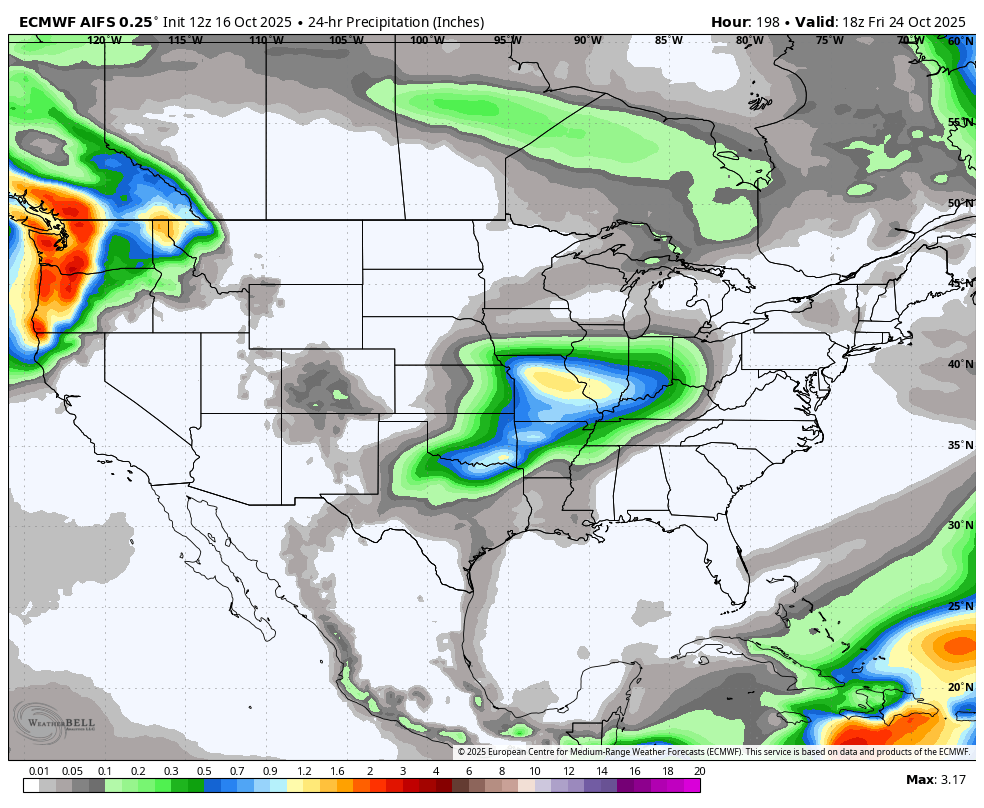
Figure 5. Precipitation potential next Thursday evening and Friday morning
Warm weather continues
By late next week a strong jet extension will be crashing into the Pacific Northwest and delivering tremendous precipitation. The result of that looks to be a strong ridge developing downstream into the central and eastern U.S. As such, it likely will be warm next weekend and perhaps near-record warm as we start the week after next, especially in the eastern half of the state. Highs in the 80's look probable for places like York, Lincoln, Omaha, Beatrice, and West Point and low temperatures may struggle to fall below the 60's. If temperatures don't drop below freezing in the northeastern section of the state early next week, then some locations in that northeast corner may be at risk of their latest first freeze on record.


