BLUF
Multiple chances of rain across the state in the next 10-14 days. Amounts likely to be highest this weekend in west central and south central Nebraska. Better chances of over a half inch in eastern Nebraska mid-week. Uncertainty on timing and amounts in extended but chances will certainly exist. Temperatures will be seasonally warm to downright hot in the coming days with almost everyone having a shot at 90°F+. Temperatures likely to remain warmer than average at night for much of the state through later next week. Afternoon temperatures will be dependent on cloud cover and precipitation. Highs likely to be at least in the mid 80's where sun prevails. Cooler temperatures may be back around the Equinox.
Rain chances
A current look at the 500-mb analysis shows a trough over California with ridging over the southern Plains and broader northwest flow over the eastern U.S. The trough currently in the west will be moving east over the next few days and will affect weather across the state this weekend (Figure 1). Showers and storms will be possible in the western sections of the state this evening and again later tomorrow, with an outside shot at showers this evening in central Nebraska.
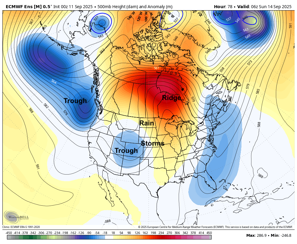
Figure 1. 500-mb height anomalies on Saturday night
Showers and storms will remain possible in the western half of the state on Saturday and chances increase into Sunday morning. Chances for showers and storms increase in the eastern half of the state on Sunday afternoon evening into Sunday night. But precipitation amounts are expected to be lighter than further west where over half an inch is more likely. Indeed, the WPC shows a reasonably good chance at a half inch of moisture across much of central Nebraska with lighter amounts toward the east where forcing is expected to be weaker. Severe storms are not likely but can't be completely ruled out in western Nebraska tonight. Winds also will be on the breezier side this weekend, especially between Highway 83 and Highway 81.
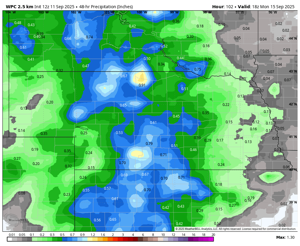
Figure 2. WPC projected rainfall totals between noon Saturday and noon Monday
Monday looks to be dry statewide but attention then turns toward another slow moving upper-level low coming into the Central Plains. This will open up additional chances for rain starting as early as Tuesday with even better chances for precipitation on Wednesday. There will be a fetch from the Gulf coming into the state and it it possible, perhaps likely, that the shortwave coming in next week could be a bigger rain maker for the eastern portion of the state than what is coming this weekend. Current probabilities of receiving over an inch are low but this may bear watching as we get into next week.
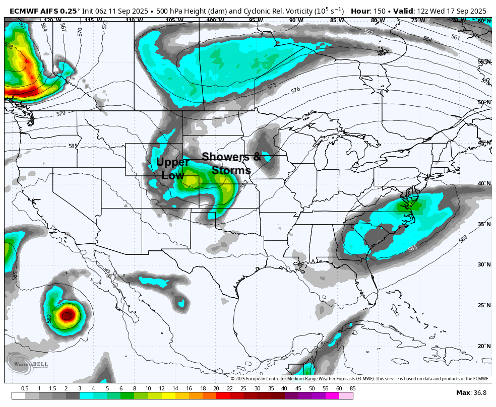
Figure 3. 500-mb vorticity map on Wednesday morning. These maps are useful for showing the location of upper level lows and where rising motion will be more favored based on the atmospheric "spin".
Warm temperatures
Temperatures have returned to above seasonal levels after a longer stretch of cooler temperatures and will generally remain on the warm side for the next week. Tomorrow may be the warmest day for much of southwest and central Nebraska with Saturday likely being hottest in the east. Highs may exceed 95°F around McCook tomorrow and will be in the lower 90's for most of the eastern 2/3 of the state. On Saturday, cloud cover is expected to help keep temperatures down a little more in the western half. Eastern Nebraska (including Lincoln) is likely to have more sunshine and be in the lower 90's on Saturday afternoon. Heat index values for the football game will be in the 90's, though a southerly breeze should help some.
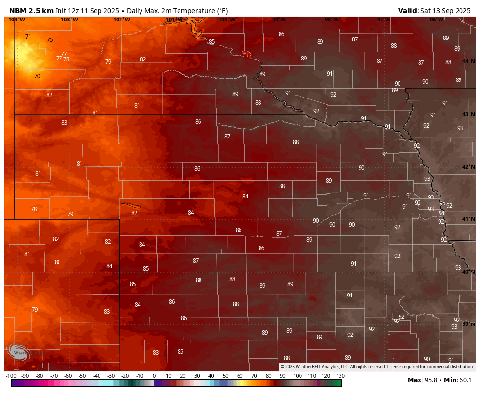
Figure 4. Projected high temperatures on Saturday
Temperatures likely will cool on Sunday with rainfall and cloud cover having an impact before rebounding on Monday and Tuesday into the mid 80's. Temperatures thereafter likely will be dependent on timing of the upper low and associated precipitation and clouds. Areas with more sun likely will remain seasonally warm through Thursday.
Extended outlook
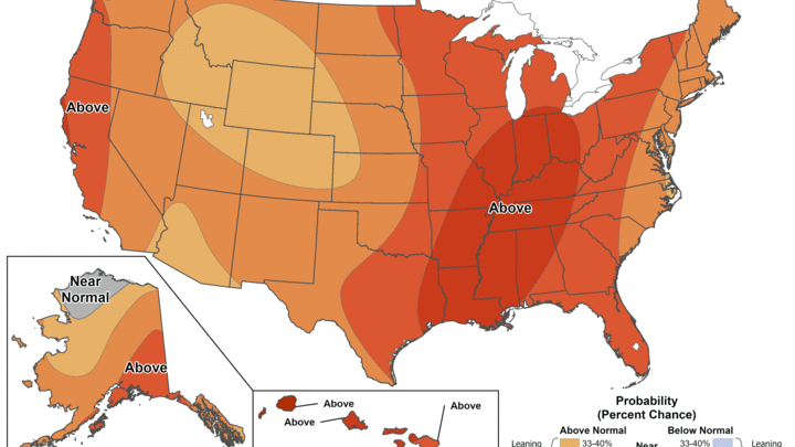
The CPC favors above average precipitation and warmer than average temperatures in the 8-14 day outlook (Figure 5). There is signal in the models for another upper level low to make its way into the Central Plains during this time period, which would help lead to chances for moisture between the 20th and 24th. The bigger questions revolve around timing and strength. The latest ECMWF AI model run (Fig. 6) shows multiple shortwaves coming out of the Rockies starting next Saturday, which could make for a soggy weekend and start to the week after next. Recommend paying attention to the forecast next week to determine whether or not rain gear is needed for the game next Saturday.
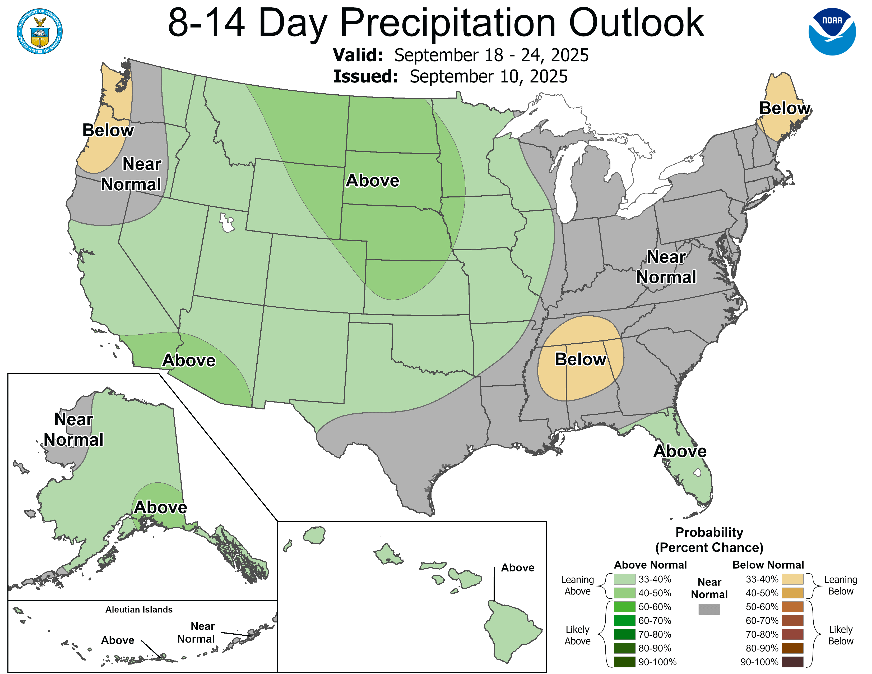
Figure 5. CPC 8-14 day precipitation outlook
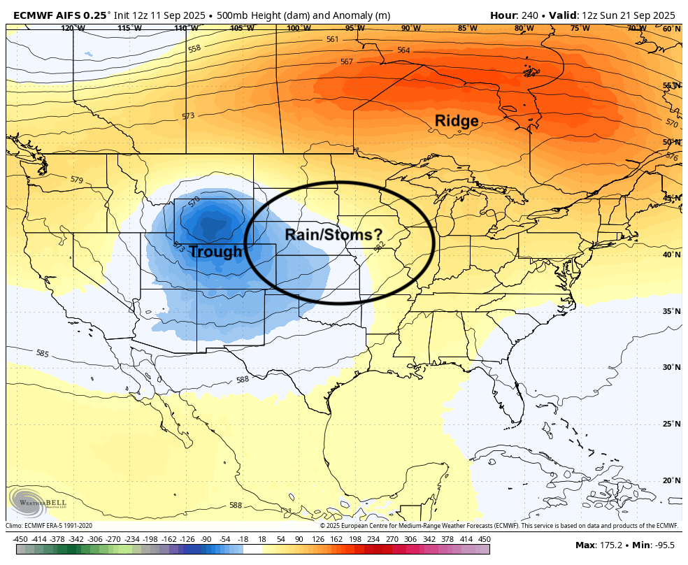
Figure 6. Projected 500-mb height anomalies next Saturday


