Reprieve from the heat
A quick look at upper-air analysis shows a deep trough over eastern Canada and off the coast of British Columbia with ridging over Texas. At the surface a cold front that moved through earlier in the week was slowly working its way south and east. A stronger area of high pressure coming into the Upper Midwest will slowly move through the Great Lakes region and will bring some much needed relief from the heat and humidity to the entire Corn Belt.
Most of Nebraska will be in the cooler air through the weekend with central and eastern sections of the state likely remaining below 80°F for highs the next few days. There are also reasonable prospects of dropping into the upper 50's or lower 60's in the early morning hours. The western section of the state will be a bit more seasonal with highs getting into the 80's. Dewpoints tomorrow should be in the 58-62°F range in the afternoon for most of the state, which will feel a bit humid in the Panhandle but will feel glorious to those of us who put up with dewpoints near 80°F earlier this week. This will keep the heat index values well below those of earlier in the week (see Fig. 1).
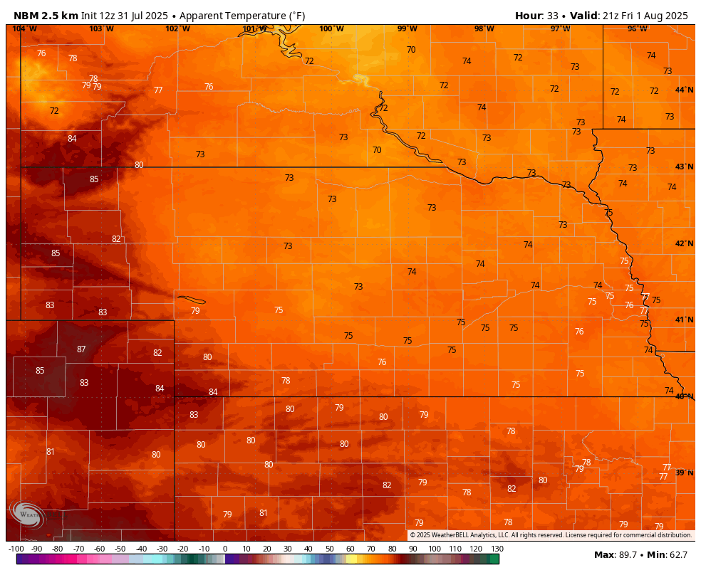
Figure 1. Projected heat index values tomorrow afternoon
The most important element of the current cool down is that overnight temperatures are finally going to stay well under 70°F in our main corn/soy areas. This will give the crops a chance to "breathe" more easily and the drier air coming into the state from the north and east also will be welcome in terms of lowering disease pressure a bit. For the first time in several years summer rainfall has been timely and adequate for much of the state; in some cases it has been downright miraculous. But the recent stretch of high overnight lows and high humidity was certainly sub-optimal.
Storm chances
There will be a good chance of showers and thunderstorms tonight across the southern Panhandle and southwest Nebraska and a good chance of scattered showers and storms between Highway 281 and 183 in the north central section of the state tomorrow. Otherwise expect pleasant conditions for outdoor activities tomorrow and most of Saturday.
Most of central and eastern Nebraska will remain dry tomorrow and tomorrow evening. But a shortwave will be entering into the High Plains region on Friday night and there will be a sufficient low-level jet coming into the Central and Northern Plains. Models are showing the possibility of a complex of thunderstorms developing in South Dakota and sliding southeast into central and eastern Nebraska early on Saturday morning. Additional shortwaves will be coming in on the periphery of a southwestern ridge between Saturday night and Wednesday.
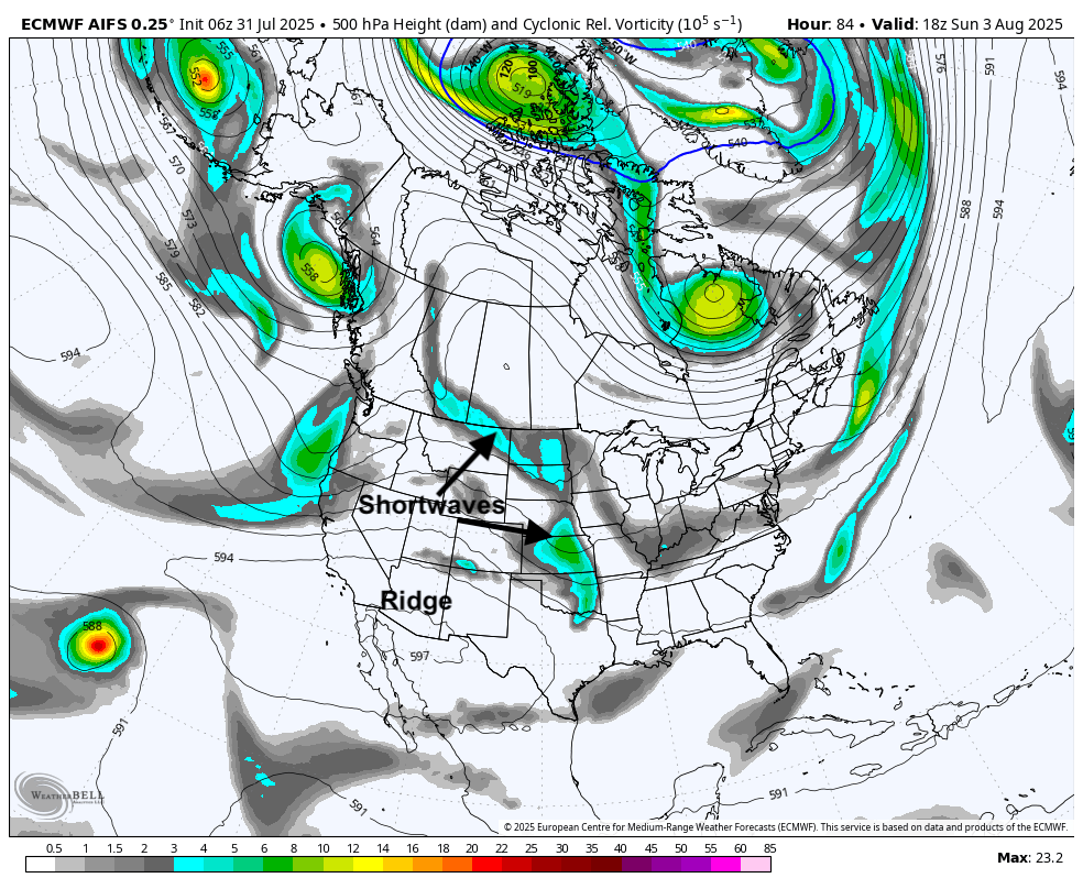
Figure 2. 500-mb heights and depiction of atmospheric vorticity (aka shortwaves)
Thus, there will be good chances of showers and storms for most of the state between late Saturday and Sunday afternoon. There will be a chance of storms on Monday and the eastern section of the state has a good shot at storms on Tuesday night. Rainfall totals are going to be highly dependent on where storms end up and there will be continued disparity in rainfall totals. But most of the state has a reasonable chance at picking up a half inch of moisture over the next several days.
Figure 3. Projected precipitation totals over the next seven days
Warming up
Ridging will likely expand northward in the middle of the week. This will allow temperatures to warm back to seasonal to seasonally warm levels in the upper 80's and low 90's in much of central and eastern Nebraska, with mid to upper 90's in western Nebraska by Thursday and Friday (Figure 4). A front may push through the state by next Saturday so the warmer temperatures may be short lived. Dewpoints are likely to be elevated in the eastern half of the state the second half of next week, with some indications of dewpoints getting into the upper 70's in northeast Nebraska on Thursday. So heat index values are likely to make a good run at heat advisory criteria in the afternoon and early evening hours next Thursday and Friday.
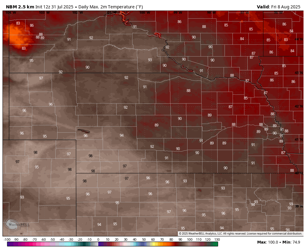
Figure 4. Projected high temperatures next Friday
Storms and cooler weather next weekend?
Rainfall also will be less likely Thursday and Friday across the state as the storm track will likely be to our north. The question is does the ridge remain entrenched over the southwest or does it get displaced toward the west.
Figure 5. CPC's 8-14 day outlook
The CPC favors better above average precipitation to our north and east and below average to our south and west. But there is signal in the AI runs that a trough will be coming back into the north central U.S. next weekend. If this comes to fruition, there will bring a good chance of showers and storms later next weekend and seasonally cool temperatures for a few days early the week after next.
Extended outlook
There are indications we could turn over drier and warmer in mid-August (Figures 6-7). So we aren't completely out of the woods for having to be concerned about drought turning worse in areas where we the soil moisture reserve is more marginal.

Figure 6. ECMWF projection of precipitation anomalies in the 7-day period ending August 20.
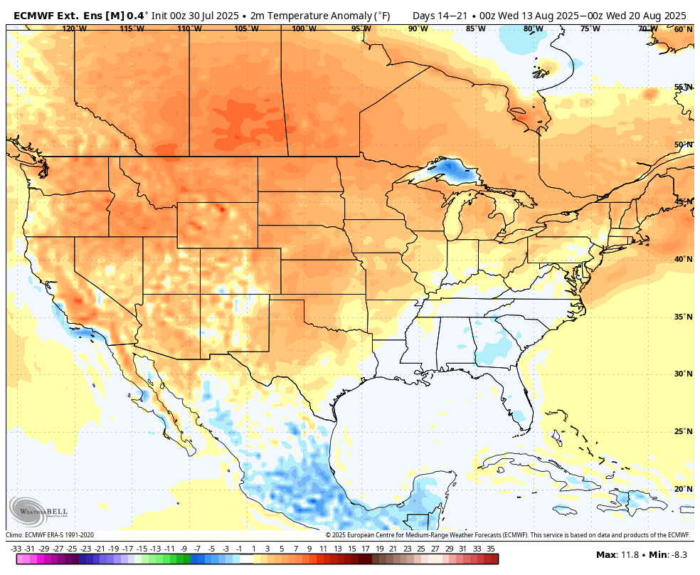
Figure 7. ECMWF projection of temperature anomalies in the 7-day period ending August 2.0
But the faucet isn't likely to fully shut off in the next ten days and the ECMWF weeklies also show more normal precipitation being favored later in the month. So there does not appear to be significant risk of flipping back over to an extended stretch of dry weather that could hurt the crops finishing. Could certainly still happen this fall but the prognosis for moisture in August is still respectable in my opinion. It's also possible some areas of central and eastern Nebraska may have enough soil moisture by mid-August for the crops to be made if we can get one more good shot of moisture between August 20th and Labor Day.