Wet Friday night in southeast Nebraska?
The front that moved through last night is now quasi-stationary to our southeast. Behind it we have cooler temperatures statewide but it is still relatively humid, especially in southeast Nebraska. This front will progress a little bit more over the next 24 hours but is likely to stall and then start retreating as a warm front on Friday night. There are disagreements in exactly how far north the front makes it but there will be a shortwave coming into the area, so showers and storms will likely develop along and north of the front. Where that front is will determine who gets heavy precipitation.
The best chance right now looks to be down in Kansas and northwest Missouri. The far southeast corner also has a chance of receiving significant precipitation in this scenario. But it's possible most of the rest of us are mostly dry tomorrow night. But all of southeast Nebraska is currently in the slight risk for excessive rainfall on Friday night into early Saturday so how much progress the warm front makes will need to be watched.
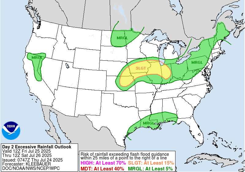
Figure 1. WPC's excessive rainfall risk
Heat
The ridge will expand north and west over the weekend and by Monday morning is expected to be centered over Kansas. This is not a record setting ridge but a 597-dm height for 500 mb is still pretty stout and many people will be miserable.
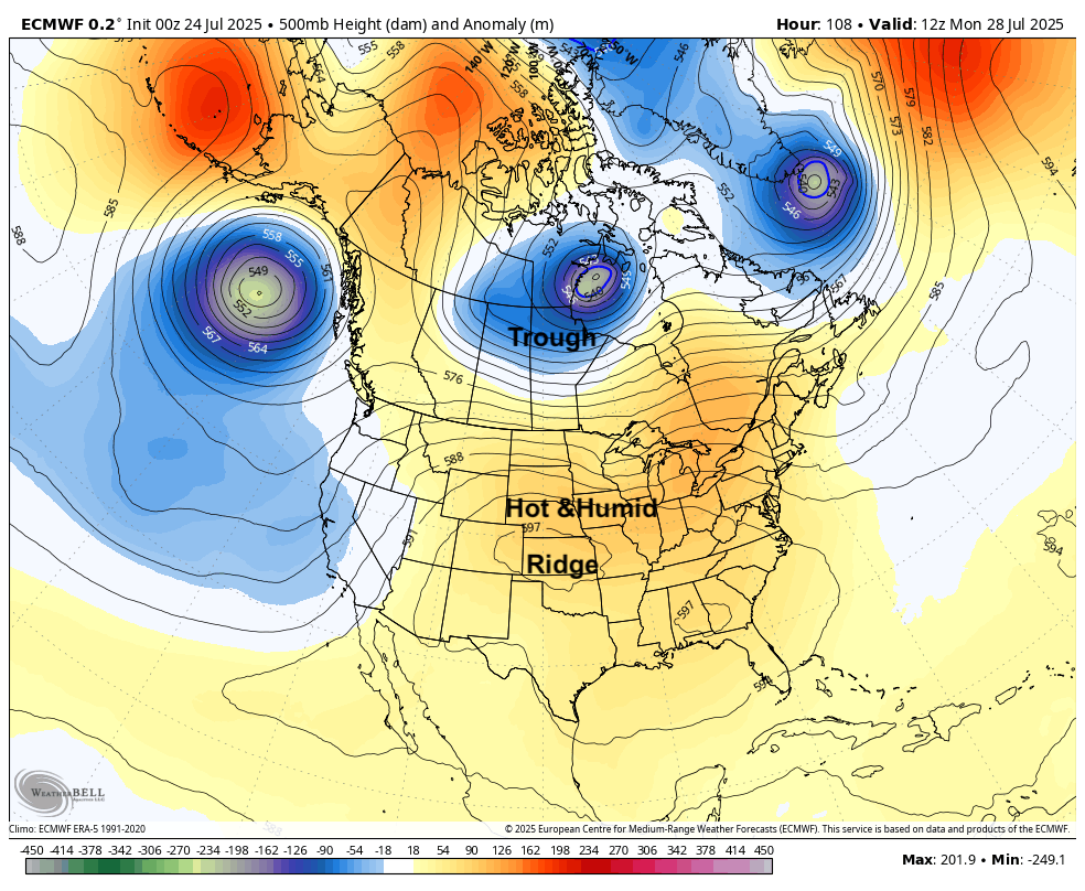
Figure 2. 500-mb height anomalies on Monday morning
Given the location of the ridge, there will be plenty of heat and sunshine to start the week. Monday looks to be the hottest day of the week with temperatures in the lower to mid 90's in most of eastern Nebraska and mid 90's to lower 100's in western Nebraska. It also will be quite humid for most of us, especially in far eastern Nebraska, so it is likely that heat index values will be reaching heat advisory criteria early next week across the state.
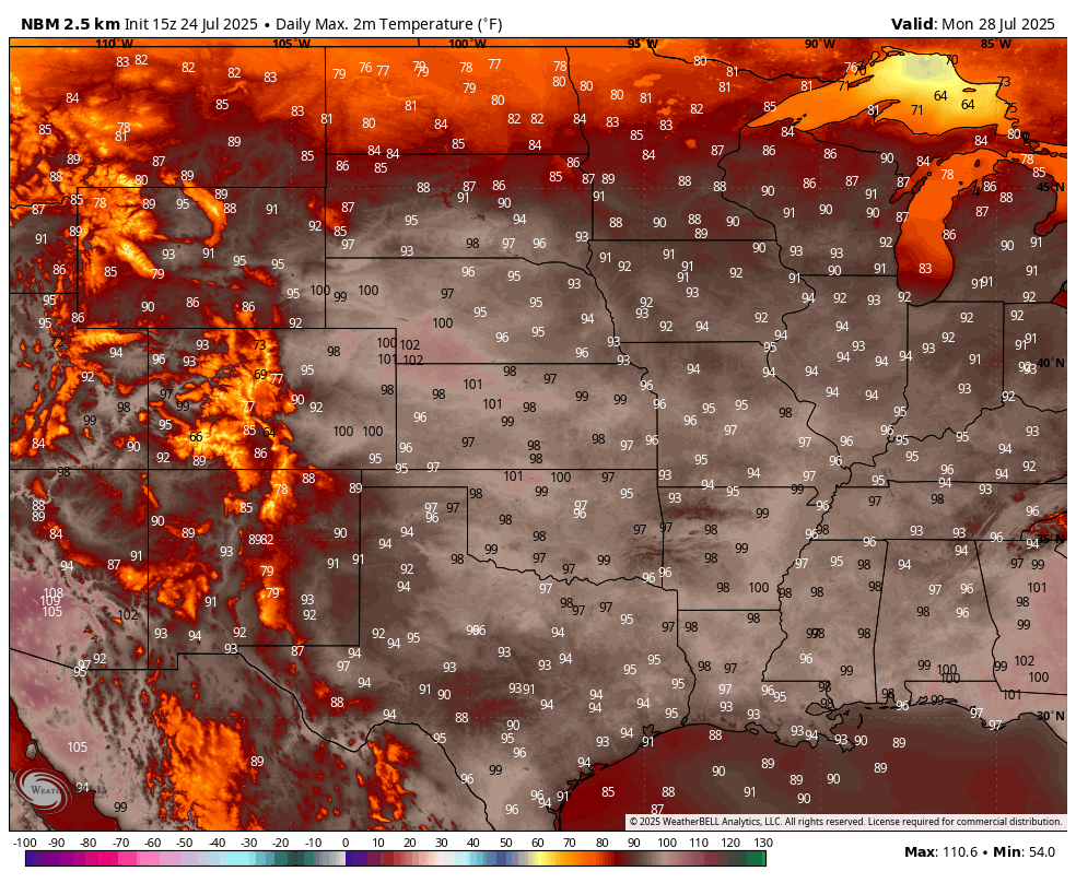
Figure 3. Projected high temperatures
Storms and relief from the heat
This does not appear to be a prolonged stretch of heat though as the ridge flattens out and a trough moving into the Great Lakes region helps drive a surface cold front through the entire north central U.S. This front should be entering Nebraska by late Tuesday and will slowly make its way through the state on Wednesday. So while Tuesday will still be hot to very hot statewide, it should be the last day of oppressive heat for the week for most. Showers and storms are possible on Tuesday night across the northern section of the state and there will be good chances for rain and storms across most of the state on Wednesday into early Thursday. The WPC is bullish on most of the state picking up an inch. But as has been the case for much of the summer, some places could get much more while others pick up less.
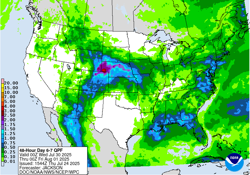
Figure 4. WPC's projected precipitation amounts between Wednesday and Thursday
Temperatures will cool off significantly behind the front and it is possible much of the state could be looking at multiple days in a row with high temperatures in the 70's starting next Thursday. There initially should be some relief from higher humidity and overnight lows may drop below 60 in parts of northeast Nebraska on Friday morning.
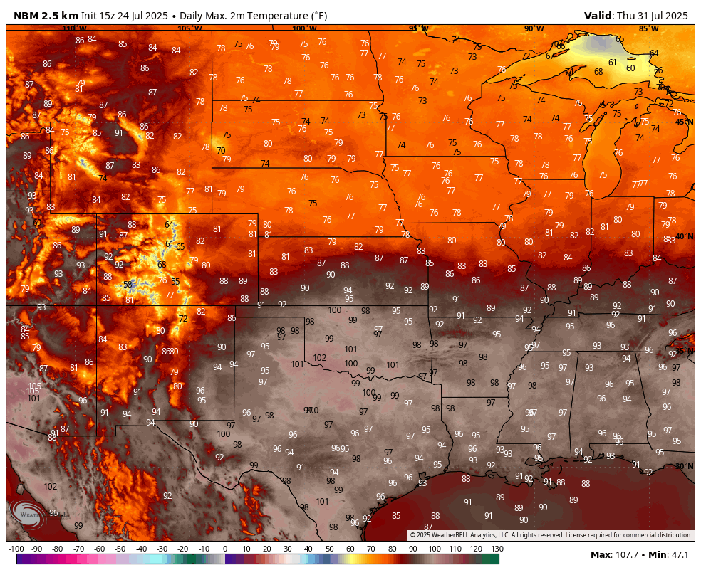
Figure 5. Projected high temperatures on Thursday
Good rain chances and cloudy finish to week
By late in the week there should be decent moisture return going up into the High Plains and Front Range regions. A shortwave looks poised to move into the High Plains by late Thursday and this should help initiate widespread rain and thunderstorms in the western part of the state. How far east the precipitation makes it on Friday is a bit of a question mark. But it seems reasonable there will be good chances of an additional 0.50-1.00" in central Nebraska on Friday and chances for some additional precipitation in eastern Nebraska as well. Regardless, it does look to be on the cloudy side to round out the week across most of the state. That will help keep the afternoon temperatures down but the relative humidity values may remain elevated for long stretches. Thus, the disease pressures we have seen around the state and region will likely persist.
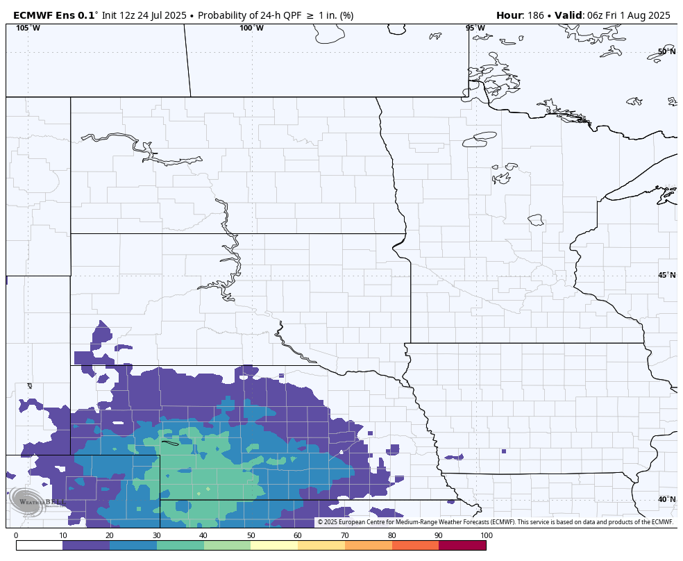
Figure 6. ECMWF ensemble probability of 1" of precipitation in a 24-hour period ending early Friday