I wish it would rain down
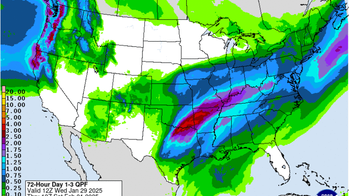
A storm system that is currently over the southwestern U.S. will move into Texas and northeast into Missouri over the next 48 hours. There is abundant moisture being drawn into the system but the question is how much will make its way back into Nebraska. For the Panhandle and northern sections of the state, this will likely be a dry event. The question is how much precipitation falls across south central and southeastern sections of the state. The low should track just south of Kansas City and if temperatures were seasonal, this could be a big snowstorm for parts of the Western Corn Belt. But this isn't tapping into any real cold air, so precipitation should remain all rain.
The total amount of rain is a bit in question but heaviest amounts are likely to be in the far southeast, where between 1-2 inches is possible. There likely will be a cutoff around Highway 30 for measurable precipitation, though some rain is possible tomorrow afternoon as far north as Norfolk and Wayne. The high-res models and the ECMWF have been leaning more toward a tenth to a quarter inch for the I-80 corridor east of Ogallala.
Mild temperatures, then cooler
Mild weather returns this weekend. Highs on Saturday will be over 50°F everywhere and may exceed 70°F in parts of southwestern Nebraska. A front starts to the move into the state on Sunday so that will bring temperatures back into the 40's for the northern section of the state but areas along and south of I-80 can expect another day in the upper 50's to low 60's. With the lack of snow cover and dry ground, temperatures have been exceeding projected values of late. It will also be a breezy weekend in western Nebraska.
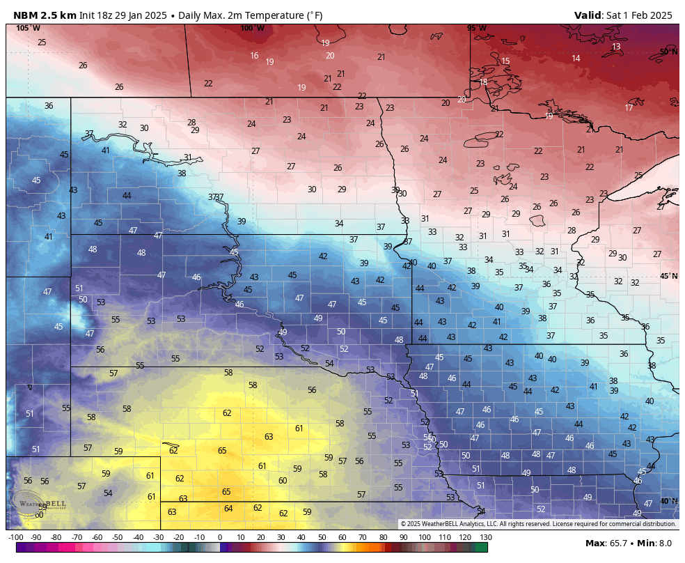
Figure 2. Projected high temperatures on Saturday.
After the frontal passage, temperatures next week will be seasonal to seasonally cool. The coldest air is likely to remain to the northwest of Nebraska but it may sneak down into the northern Panhandle next Tuesday-Wednesday. Expect highs in the 25-30°F range in the northern third of the state with highs in the 30's elsewhere. Low temperatures likely will be in the single digits across the northern and western parts of the state and in the teens elsewhere.
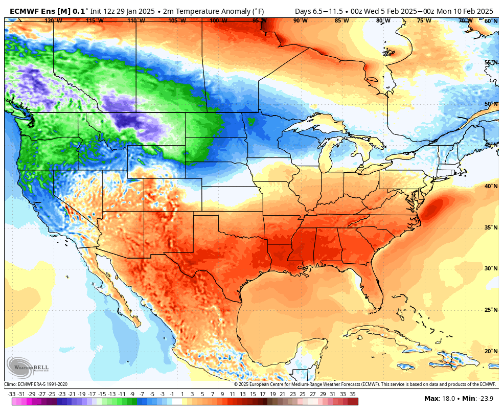
Figure 3. Temperature anomalies between February 5th and 10th
Dry next week
A storm system looks to enter the Pacific Northwest next week and at this point, it looks to track to the north of Nebraska. There will be a chance of light snow on Wednesday and early Thursday along and north of Highway 20 but any accumulations will likely be light. Otherwise it looks dry next week across the state.

Figure 4. Probability of 1" of snow next Wednesday-Thursday
White Valentine's?
A more active pattern may be setting up after Super Bowl Sunday, which would mean a chance to start getting some snow across our region. The ECMWF and GFS ensembles are both showing the chance of a system that could produce accumulating snow around February 11th-12th. A ways out but the CPC is in agreement with a wet signal in the 8-14 day outlook. Many areas in the state are running at or near-record low values for snowfall so far this season and January has been abnormally dry in general. So moisture of any kind we get in mid-February would be welcome.

Figure 5. 8-14 day CPC outlook
Colder temperatures prevailing
The European model shows seasonally cold temperatures may be the rule through much of February across the north central section of the country. This, of course, does not mean every single day will be cold and it doesn't look to be brutally cold. But it does mean that this weekend may be the last of the very mild days for a little while at least.
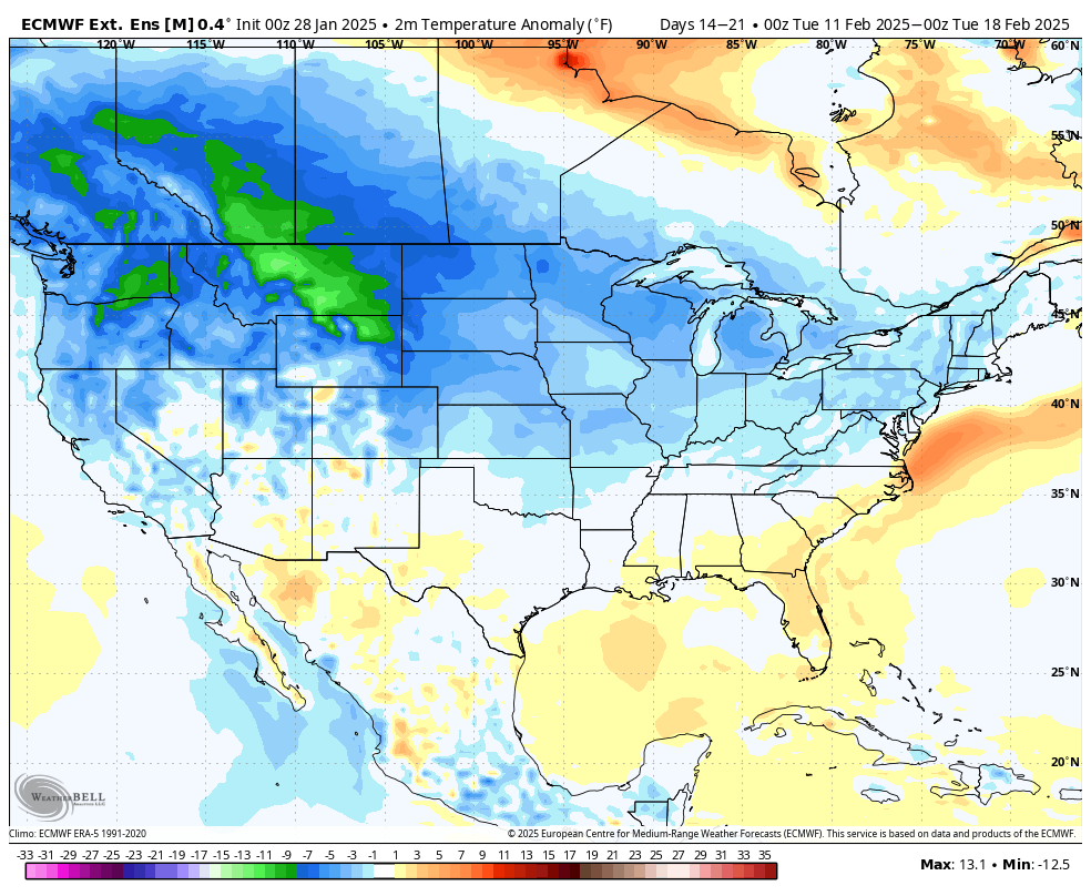
Figure 6. Temperature outlook from the ECMWF for the period 11-17 February.