Four Consecutive Nights of Heavy Rainfall
The expansive upper-level ridge of high pressure centered over the eastern U.S. led to a major heat wave in the east and a several-day "ring of fire" event in the Great Plains and Upper Midwest this week. Many (but not all) areas of Nebraska were in the thick of the action starting on Sunday night. Most of the storms occurred between mid-afternoon and the overnight hours, which is typical in this type of atmospheric setup. The remainder of the article offers a day-by-day account of the progression of the event.
Sunday Night
After a few days of blast furnace conditions across the state, precipitation returned to the state on Sunday evening. A cold front moved through the Panhandle on Sunday and storms formed along it on Sunday evening near Scottsbluff/Gering and in the Sand Hills. Rainfall was generous in the area around Ainsworth with totals between 1.0-1.5 inches common in Brown, Rock, Blaine, Loup, and western Holt counties. Heaviest precipitation on Sunday night fell around O'Neill and northern Wheeler counties where amounts over 3" were common. Over an inch fell in 20 minutes during the most intense rates.
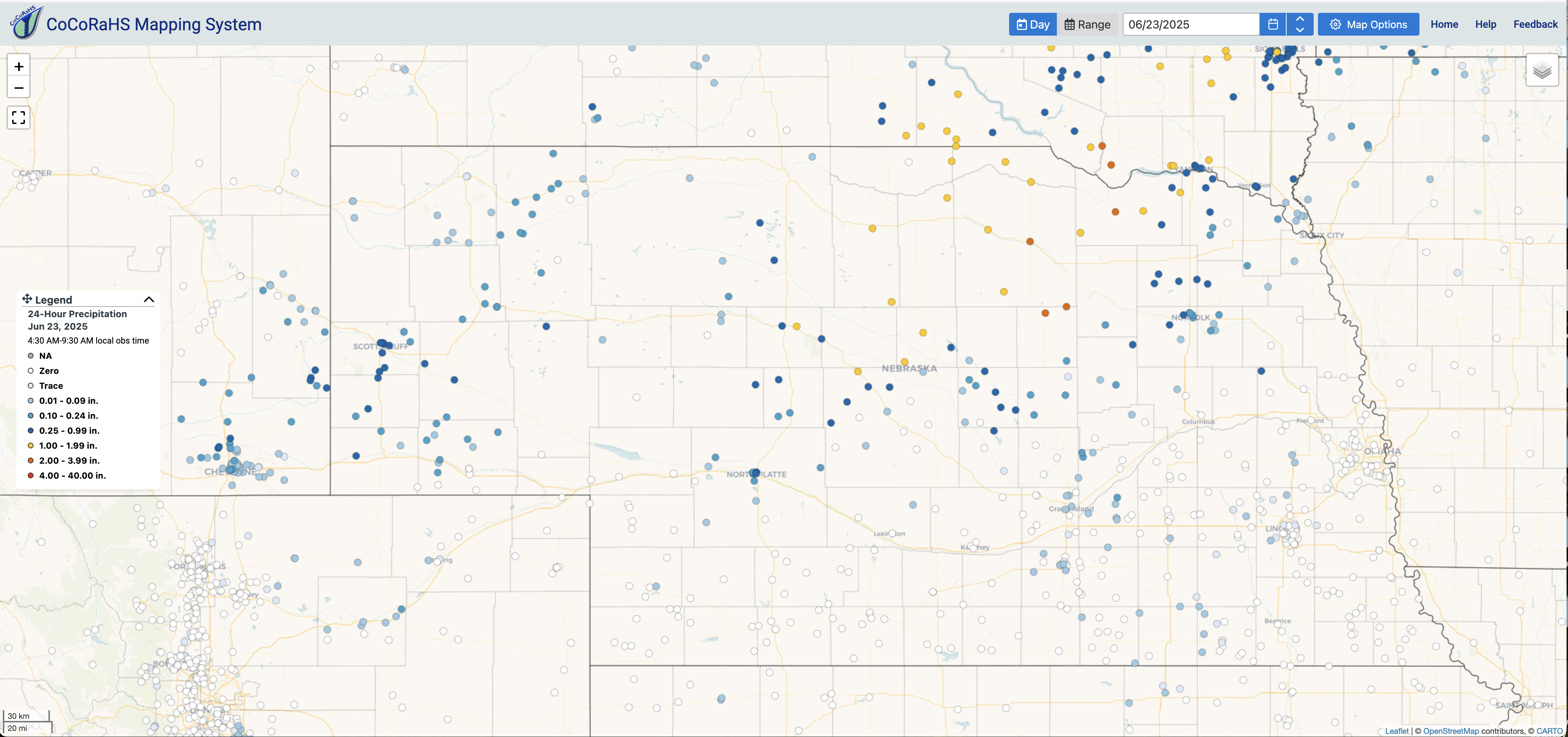
Figure 1. CoCoRaHS observed precipitation ending 7 AM Central on June 23rd
Monday afternoon and night
The front moved southeast through the state during the day on Monday bringing sharply cooler temperatures behind it, with highs only in the 70's in most of western and northern Nebraska. Storms began to form in southeast Nebraska later on Monday afternoon and spread north during the overnight hours on Monday. Areas around Clay Center, York, Papillion, and Norfolk picked up over an inch but the heaviest rainfall was confined to the southeast corner. Amounts over 3" were common in Nemaha and northern Richardson counties with 5" reported in Brownville. Rainfall totals in excess of 4" were common in northwest Missouri and southern Iowa.
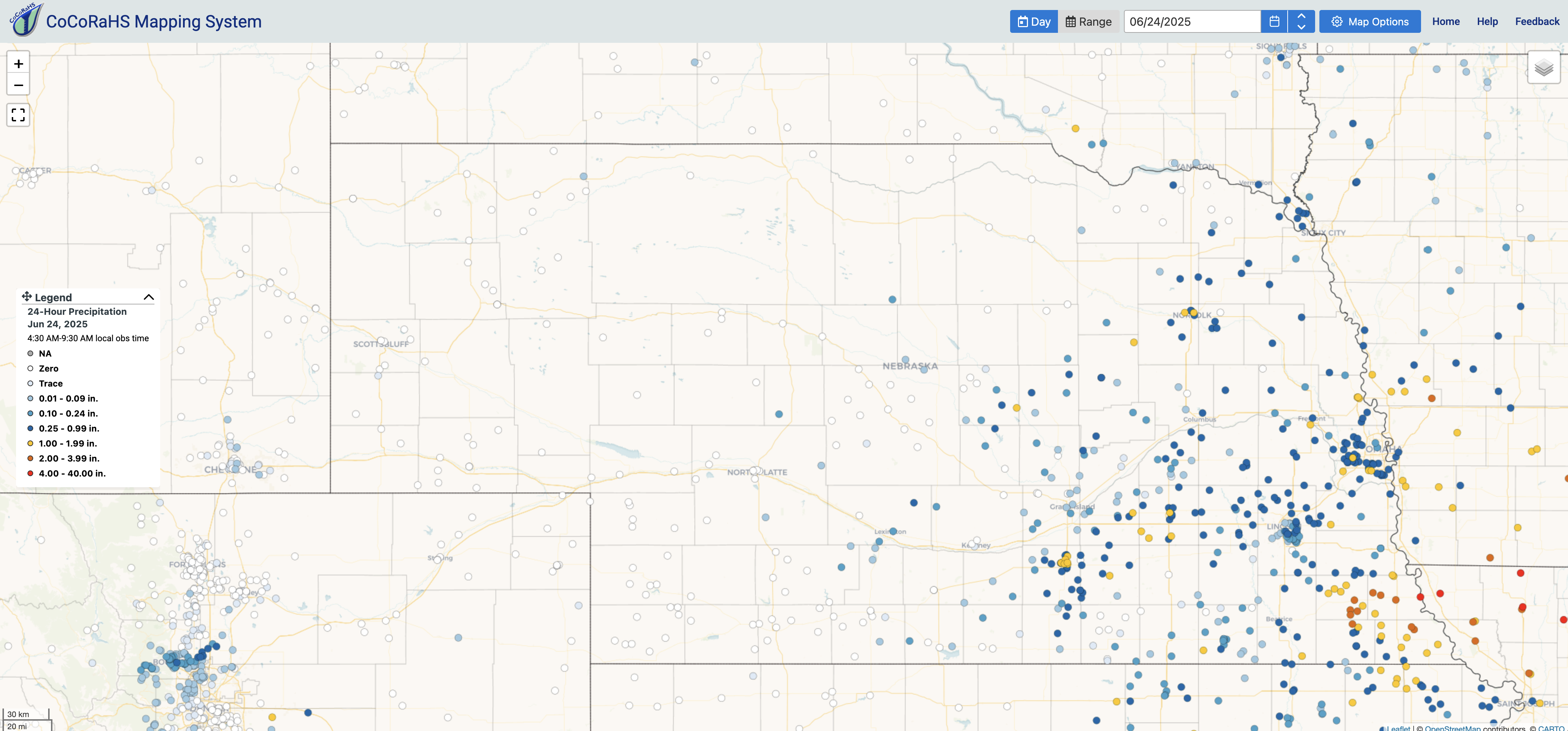
Figure 2. CoCoRaHS observed precipitation ending 7 AM Central on June 24th
Tuesday afternoon and night
By Tuesday the front had effectively stalled to the south of the state, which meant temperatures generally were in the mid 70's to low 80's for high temperatures. Showers and storms began to pop Tuesday afternoon and became numerous during the overnight hours while slowly moving toward the north-northeast. Only the Panhandle missed out on rainfall during this time period and most of southeast, south central, and north central sections picking up between a quarter inch and an inch of rain. Heaviest rainfall occurred in a southwest-northeast band from Imperial to Loup City, with some reports in excess of 5" in Chase County.
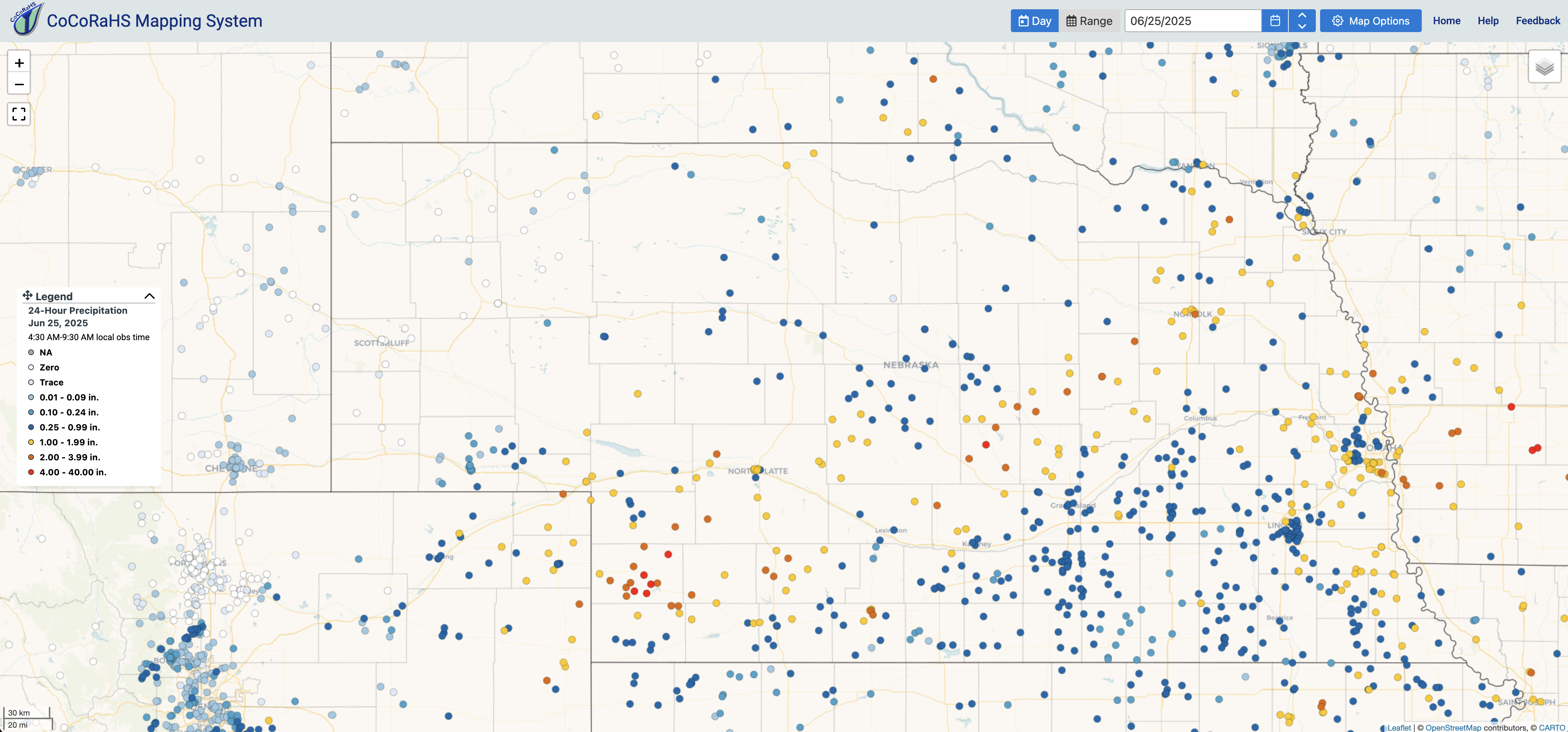
Figure 3. CoCoRaHS observed precipitation ending 7 AM Central on June 25th
Wednesday afternoon and night
The front retreated back to the north-northwest on Wednesday morning, which led to a mostly sunny, hot and steamy day in southeast Nebraska where a stronger capping inversion was in place. By mid-afternoon the front was sitting right around Highway 30 and was the focal point for storm development. The radar loop (see related links) shows the rapid development of storms around 2:30 in the afternoon and then continuing over the same areas over the next several hours. Heaviest rainfall occurred in Hall, Merrick, Howard, Platte, and Colfax counties with the highest amounts of 7.5"+ in Grand Island where major flooding occurred. To the north and west of the heaviest band, a prolonged duration of more moderate rainfall intensity led to a good soaking from Custer County into the northeast corner of the state. For Grand Island, this was the second ranked 1-day precipitation event (only to May 11, 2005) and was the wettest two-day event on record.
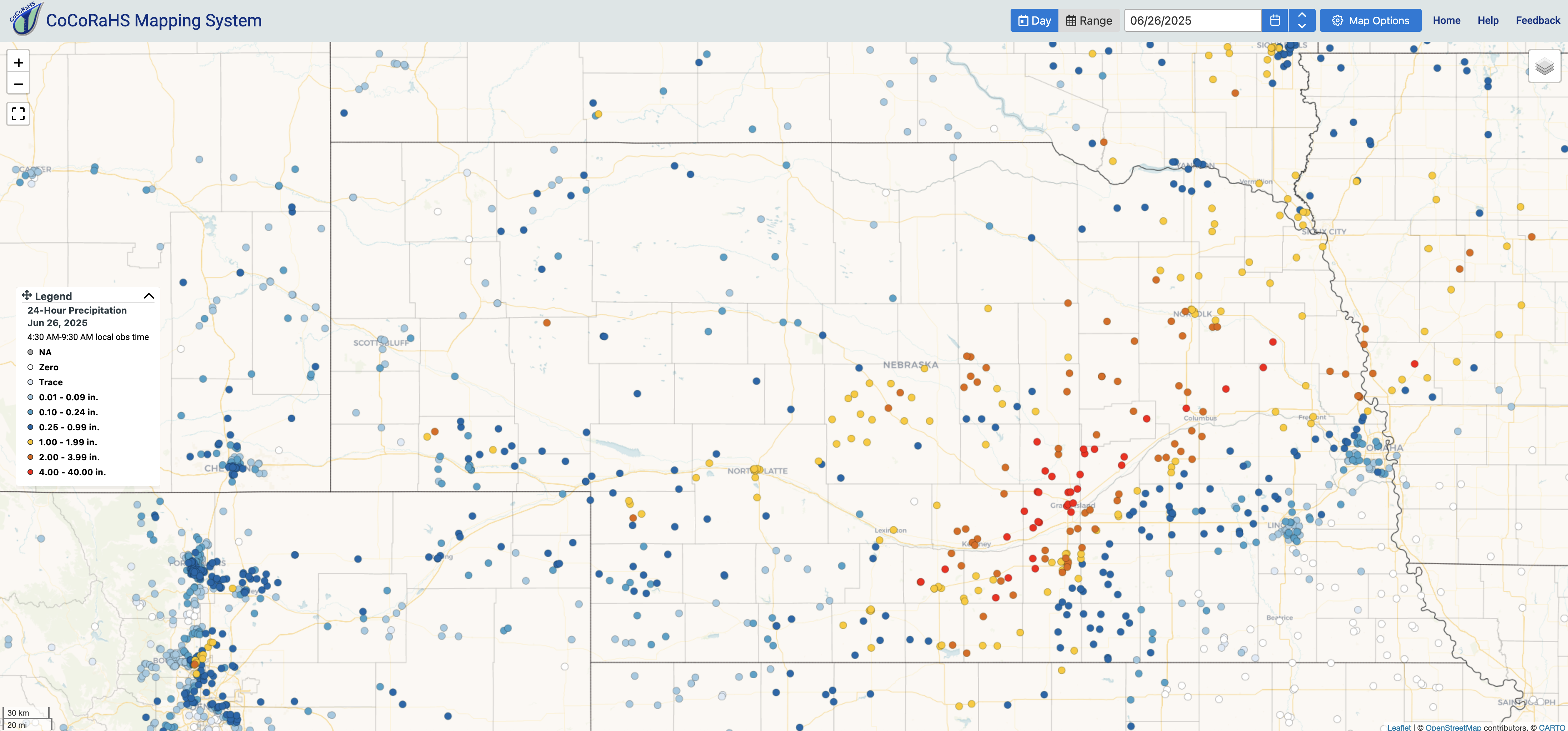
Figure 4. CoCoRaHS observed precipitation ending 7 AM Central on June 26th
Soil moisture and drought update
Soils are now quite wet relative to average according to NASA's SPORTLIS model in areas that received the heaviest precipitation over the past several days. Most other areas are now mostly in the near-normal range, which is a dramatic improvement from six weeks ago. Much of the rain fell after the cutoff for this weeks Drought Monitor, hence why the area around Grand Island was still classified in severe drought. Improvements will be forthcoming next week. Outside of the northwest corner, the area of the state that missed out on good moisture was the area centered around Geneva in Fillmore County. This area shows up as very dry on the soil moisture percentiles, a reflection of the lack of recharge after last week's blast furnace. If the front had stopped 50 miles northwest of where it did on Monday, the story there (and around Lincoln) would be pretty different. Areas that had under a half inch this last week in southeast NE will be watched carefully for flash drought.
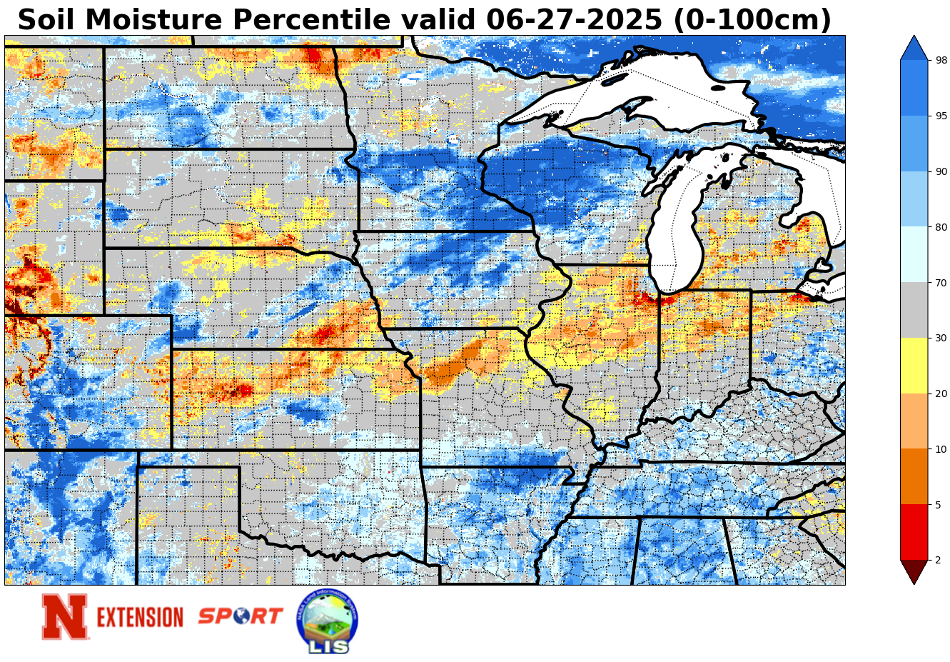
Figure 5. Soil moisture percentiles as of last night
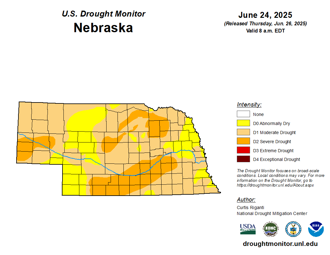
Figure 6. Latest U.S. Drought Monitor