Severe storm risk
A current look at upper air analysis shows a deep trough off the west coast with broader ridging in across the southeastern U.S. At the surface, the Bermuda High is expansive and westward shifted, which will keep the southeast dry and warm this weekend. No rain at the Master's this year! Here in Nebraska we are on the cool side of a front and have seasonally cool temperatures statewide with winds from the east-northeast across most of the state.
By tonight a shortwave will move into the Central Plains region and combined with help from the low-level jet, this will help initiate an area of showers and thunderstorms across south central and eastern Nebraska. Storms likely will develop around midnight near the Kansas-Nebraska border and move east-northeast through the early morning hours. Rainfall totals will vary with convection but most of those regions should see over a tenth of an inch. Some areas could get near an inch.
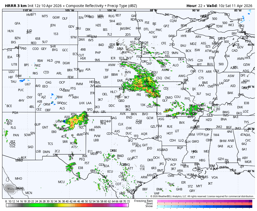
Figure 1. NOAA HRRR projection of precipitation tomorrow morning
Much warmer temperatures will spread into the most of state tomorrow with highs in the 80's in western Nebraska, 70's in central and southeast Nebraska, and 60's in the northeast Nebraska. Severe storms are possible again in the eastern Nebraska tomorrow afternoon and evening. Biggest risk would be hail but there is a small tornado risk in southeast Nebraska.
Taste of summer
Warm, southerly flow will be dominant in the first part of next week and temperatures will be well above average statewide on Sunday-Tuesday. Highs in the mid 70's to mid 80's will be prominent and overnight temperatures will be 10-15°F above average. Temperatures will be a bit cooler on Tuesday in western Nebraska and temperatures will drop off a bit in eastern Nebraska on Wednesday after the frontal passage. It also will feel more humid, especially in eastern Nebraska where dewpoints will get into the 60's early in the week.
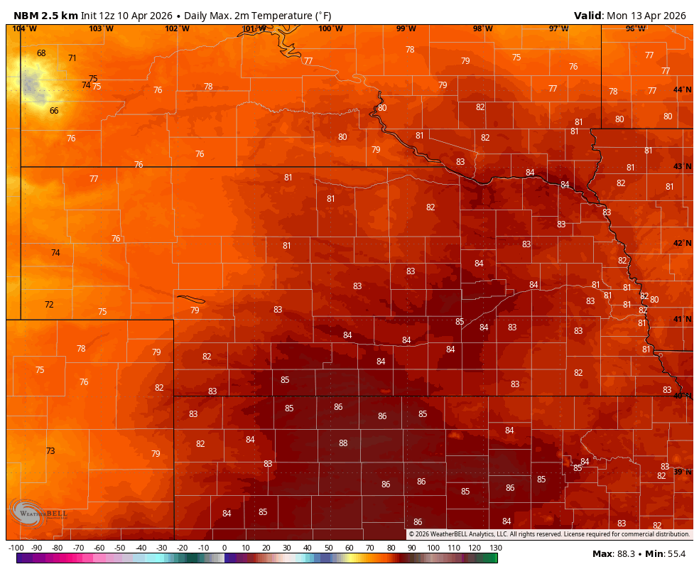
Figure 2. Projected high temperatures on Monday afternoon from the National Blend of Models
Severe storms possible
A shortwave will move into the Central Plains on Monday afternoon and with warm, humid air in place over the eastern side of the state, there will be a chance for severe storms to develop along and east of Highway 81 later on Monday afternoon and evening. The Storm Prediction Center does have the eastern side of the state in the slight risk category for Monday. How widespread the development is will depend on how "capped" the atmosphere is. Stronger capping will keep most convection to our northeastwhere upper level temperatures will be cooler.
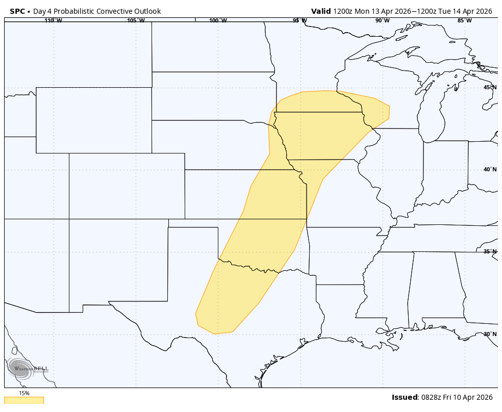
Figure 3. Storm Prediction Center severe storm risk on Monday
The weather pattern will remain active through most of next week as multiple shortwaves eject out ahead of the main trough in the southwestern U.S. Right now it appears that one surface low will enter the state on Tuesday, with a more pronounced dry slot over the eastern half of the state with showers more probable across north central and northwestern sections of the state. Severe weather also will be possible on Tuesday in the far southeast part of the state and the SPC does have that part of the state in the risk area.
Another system will move out into the central U.S. on Wednesday and this will bring chances for moisture to the eastern part of the state. The WPC is not overly bullish on much precipitation falling in Nebraska during the middle of next week and there's a chance the southwest part of the state will not pick up anything. Given that we are entering into planting season, it would appear that there be some favorable days for getting started on planting in areas where you are eligible to do so.
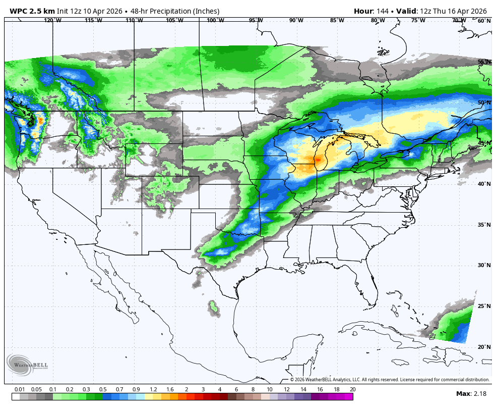
Figure 4. WPC projected precipitation between Tuesday and Thursday
Cooler end to the week
By next Friday, deeper troughing over central Canada will start slide into the upper Midwest. A cold front should move through the state on Friday and next weekend will likely see seasonally cool temperatures in the 50's and lower 60's, with freezing temperatures likely in the Panhandle next Saturday morning and possibly statewide on Sunday morning. There will be chances for showers and storms ahead of the system in eastern Nebraska on Friday afternoon but best chances reside to our east.
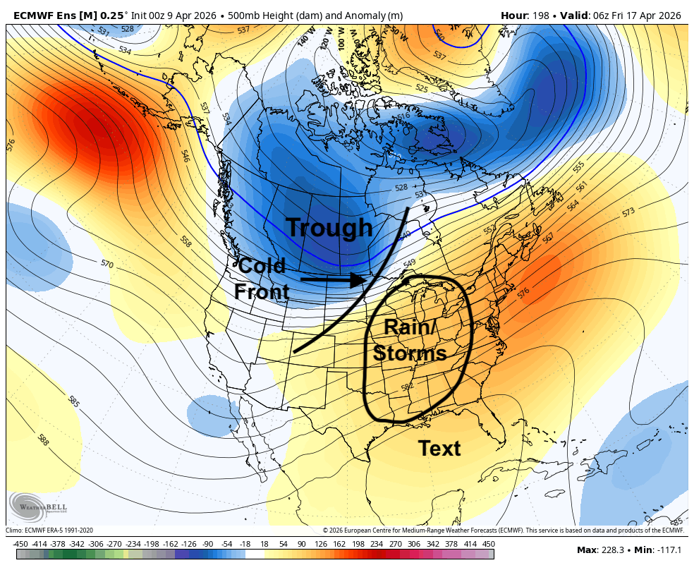
Figure 5. 500-mb height anomalies next Friday and depictions of certain surface features
Open planting windows and frost risk?
Temperatures likely would rebound nicely early on the week of the 20th with above average temperatures likely. An even more potent front is possible toward April 22nd-April 23rd, which could bring unseasonably cool temperatures to our region. The CPC's 8-14 day outlook does show above average precipitation favored in the eastern two-thirds of the state. There will be chances for moisture during that period but there are also indications in the ECMWF that much of the state will be drier than average during that period. Best chances for moisture will be to our east during that period, leading to continued drought relief and setting the 'I' states up nicely for moisture going into May.
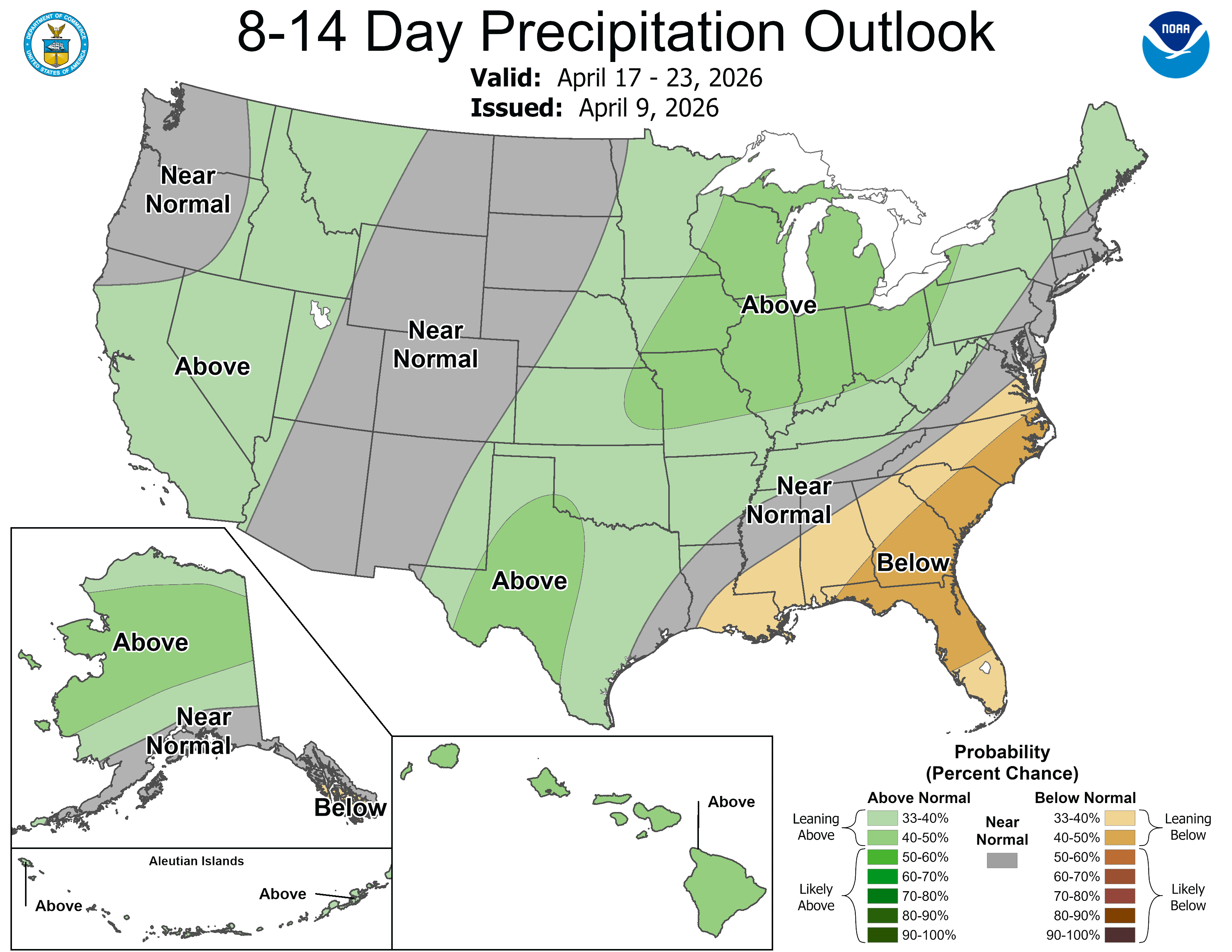
Figure 6. CPC's 8-14 day precipitation outlook
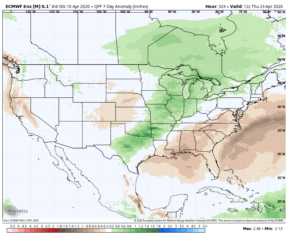
Figure 7. ECMWF ensemble projected 7-day precipitation anomalies