BLUF
Precipitation likely statewide over the next 36 hours but the best moisture will fall over southwestern and west central Nebraska. Temperatures will drop well below freezing multiple nights in the next five days statewide, which could cause issues for sensitive vegetation that started blooming. Warmer temperatures in the 70's are likely the second half of the week and showers/storms may be possible between late Wednesday and Thursday in eastern Nebraska.
Beneficial moisture
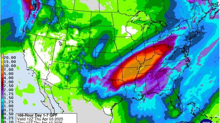
A look at the 12Z analysis shows a deep trough with a very impressive jet streak from the Southern Plains into Illinois and a very stout ridge over the eastern U.S. Over the next 24-36 hours, a shortwave associated with the main trough will be moving north from Texas into western Nebraska. This will help generate widespread precipitation overnight in southwest and west central sections of the state. Most of this will be in the form of rain but snow could mix in at times in the eastern Panhandle and the Sand Hills. Totals over half an inch are likely in Ogallala, North Platte, Benkleman, and Imperial. This is very welcome moisture for this area of the state.
The eastern ridge is going to act like a wall for the next several days, which means all of the energy and moisture output is going to be focused over a more narrow area for a prolonged period of time. Significant precipitation has already occurred in the mid-south region and historic precipitation is going to fall from Arkansas into western Kentucky and Tennessee over the next three days. This will also drench the southern and eastern sections of the Corn Belt.
Figure 1. Projected moisture over the next 48 hours from the WPC
Precipitation also will be likely overnight and early tomorrow morning in the Panhandle and into much of central Nebraska as well. During the day on Friday precipitation will be likely further east, though amounts will be much lighter than across west central sections of the state. It will be a cool and raw day for everyone with extensive cloud cover. A front will move through on Saturday morning, which will clear the precipitation out of the area but not necessarily the clouds in the southern and eastern sections of the state.
Sub-freezing temperatures
It will be a relatively chilly day on Saturday with highs in the 40's statewide. Lows temperatures will drop into the teens in the Panhandle if clearing starts early enough. Subfreezing lows are likely everywhere else in the state except the southeast corner on Saturday morning and on Sunday morning the entire state should spend several hours below freezing with temperatures below 28°F likely everywhere. Sensitive vegetation that has started blooming will be in trouble.
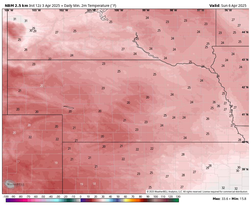
Figure 2. Projected minimum temperatures on Sunday
After a modest warm-up on Sunday, another cold front will move through the region on Sunday night with another shot of seasonally cool sir moving into our area. This will especially be the case for north central and eastern sections of the state where highs will be in the mid 40's to low 50's on Monday and temperatures on Tuesday morning will be in the 20's once again. Somewhat warmer temperatures will be found closer to Wyoming and Colorado.
Warming trend
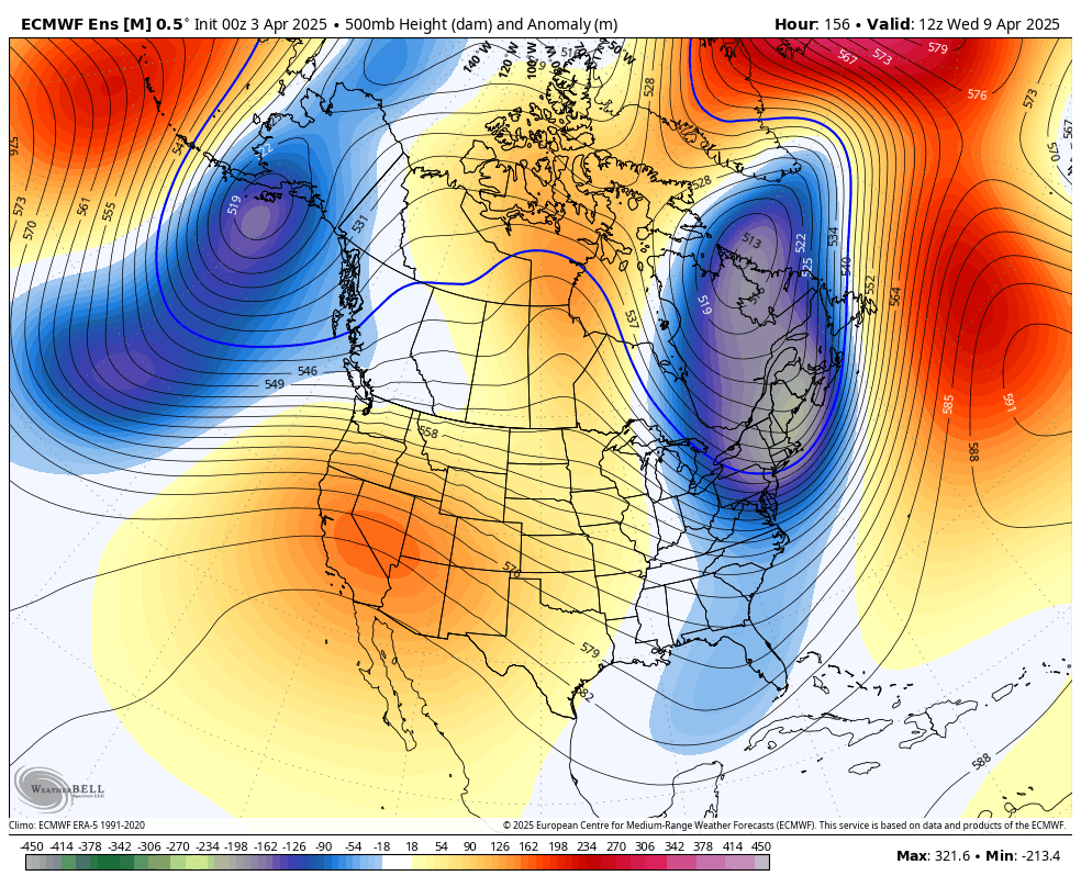
Figure 3. 500-mb height anomalies next Wednesday morning
Ridging will build from the western U.S. into the central section of the continent. This will bring warmer temperatures across the state for the latter half of the week, with highs in the upper 60's to mid 70's statewide. It does appear that there could be a shortwave coming up and around the ridge into the Western Corn Belt on Wednesday night. This would have the potential to produce precipitation in eastern Nebraska but the official forecast from the WPC is currently dry. If it was mid-summer, I'd be much more bullish on that producing a complex of storms in the Dakotas that would slide through the eastern section of the state and down into Missouri.
Warm and dry mid-April?
Conditions look to remain dry late next week with temperatures in the 70's next weekend. CPC favors drier and warmer than average in the 8-14 day period. If the ridge flattens out some in the week of the 14th, there will be chances for precipitation across the state. But I'm not overly confident in timing or possible amounts and it's possible we remain mostly on the dry side through Easter weekend. Something else to watch will be the possible return of a deeper trough coming into the Great Lakes region before Easter. That probably wouldn't bring us significant precipitation but it certainly could bring another cool shot air for everyone east of the Rockies. It certainly would keep conditions on the cool side in the Eastern Corn Belt.
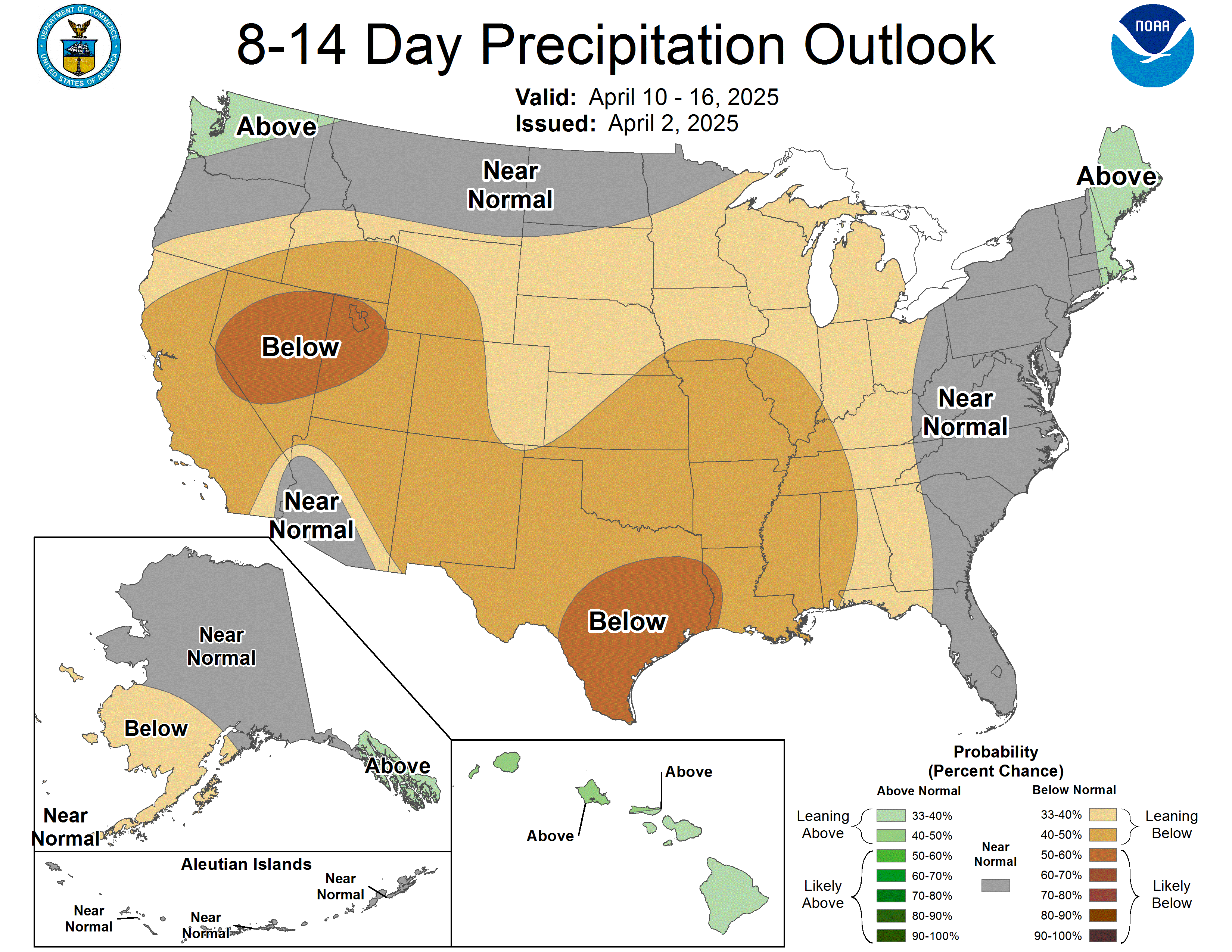
Figure 4. 8-14 day precipitation outlook from the CPC
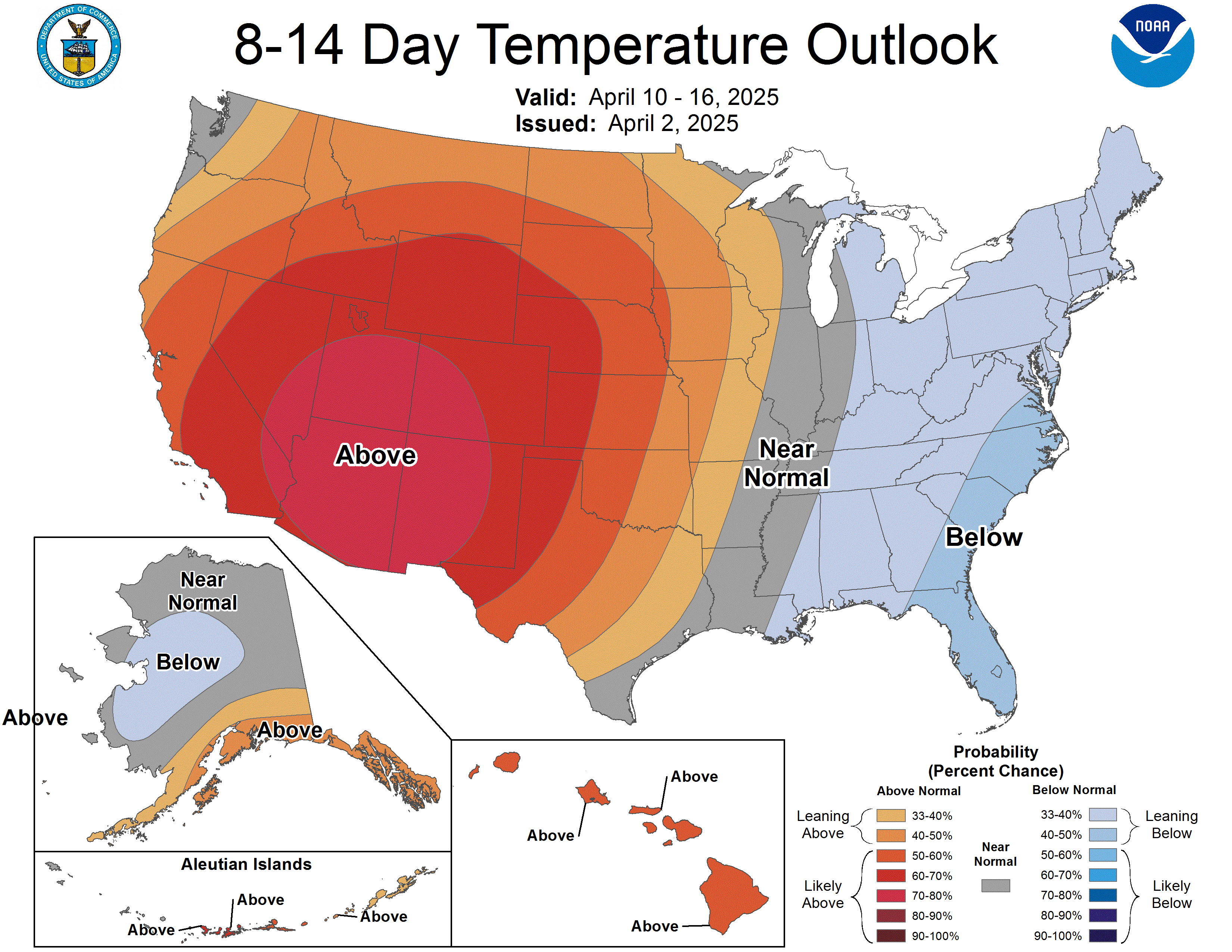
Figure 5. 8-14 day temperature outlook from the CPC
Recent precipitation and drought update
The most recent storm system brought generous precipitation from Fullerton to Tekamah and across the southeast corner. There were also some hail reports and the heavier rate of rainfall likely means that not all of the moisture went in. Over the past week a large section of the state has picked up over a half inch of moisture and pockets of the Sand Hills and northeast Nebraska have cleared two inches of moisture over that time. Soil moisture percentiles continue to improve across the northeast corner of the state and have also improved in the Sand Hills. Very good news for the pastures but additional moisture is essential.
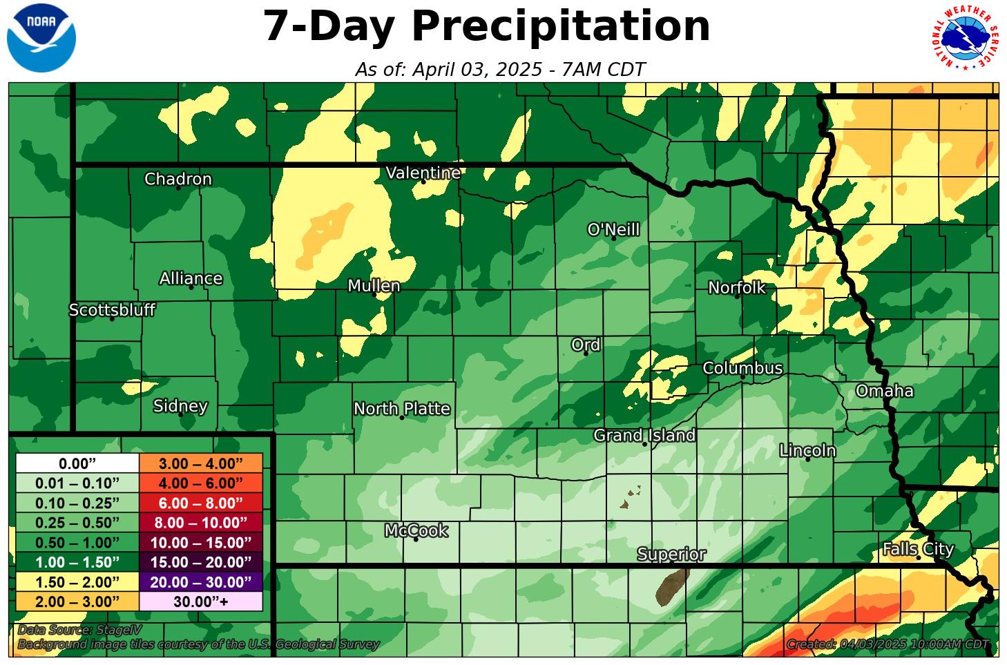
Figure 6. Precipitation totals over the last seven days
The area of the state that didn't receive much precipitation over the past week is the south central section with under a tenth of an inch falling for most of this region. Recent cooler temperatures have helped reduce soil moisture loss a little but moisture is starting to get short again along the Kansas border. The latest Drought Monitor shows a 1-category improvement over much of the western Sand Hills and parts of the eastern Panhandle from severe drought (D2) to moderate drought (D1). This reduces the areal coverage of the state in severe drought or worse to 37 percent.
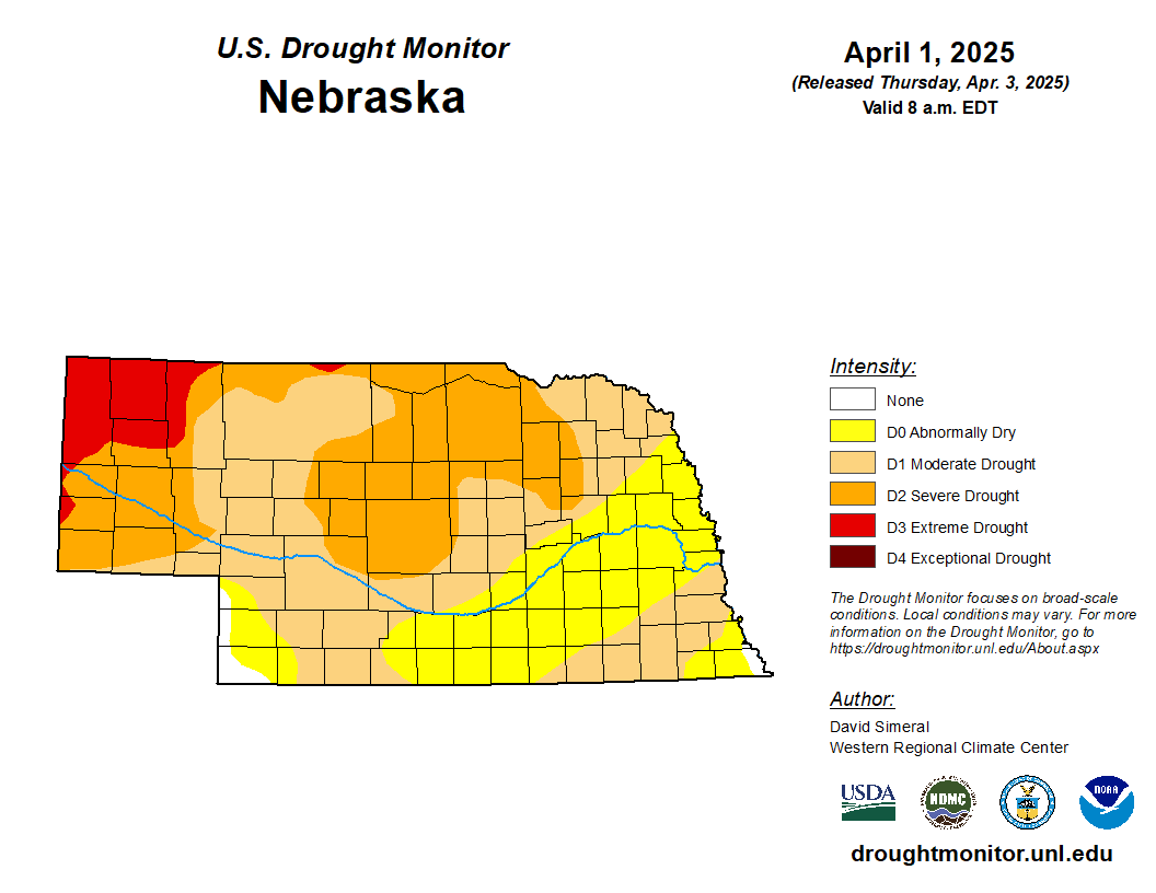
Figure 7. Latest U.S. Drought Monitor
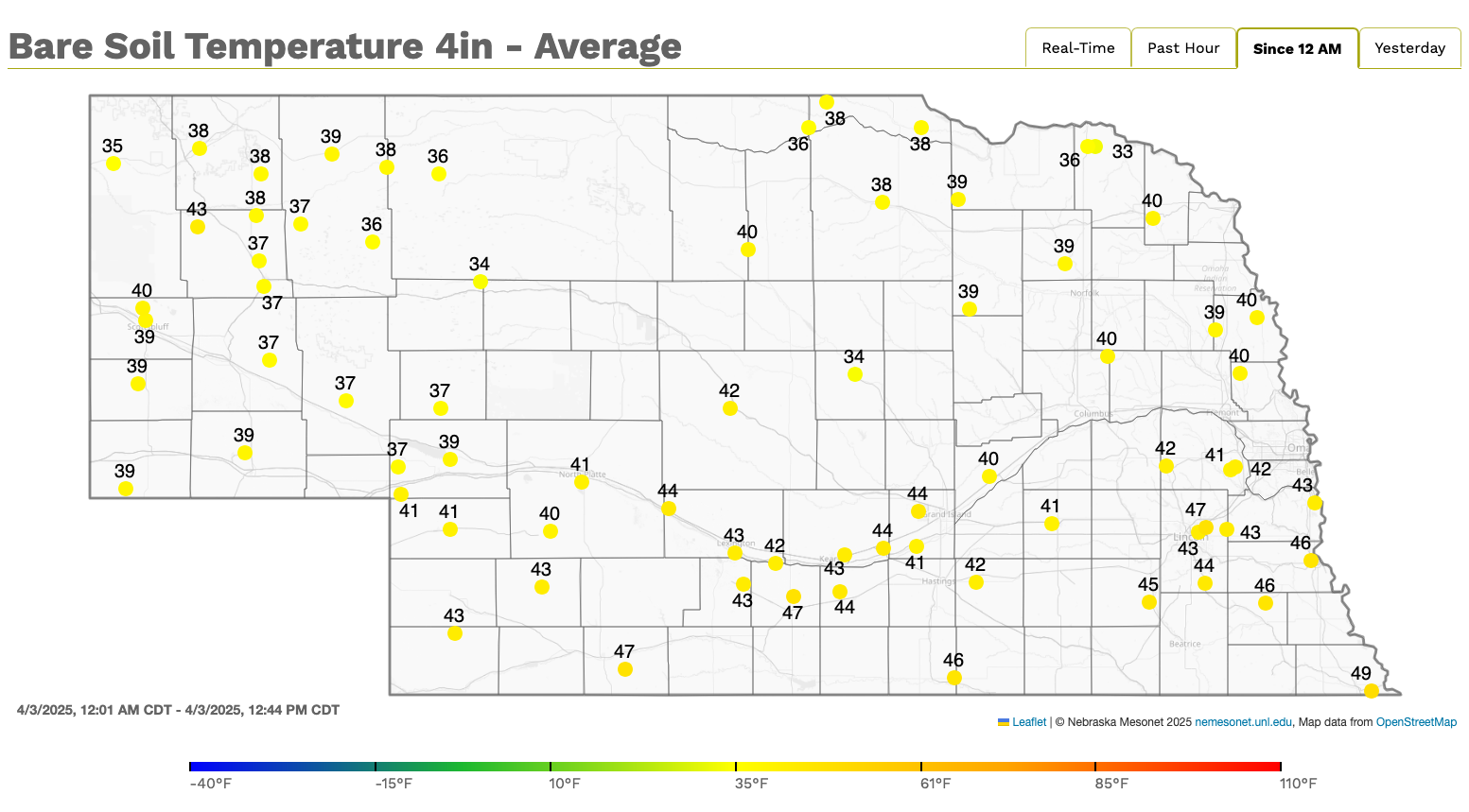
Soil temperature update
4 inch bare soil temperatures are generally in the 40's in the southern two-thirds of the state with upper 30's more common along and north of Highway 20. With the cooler temperatures expected in the next five days, these numbers will have a hard time warming up much. It would seem reasonable that daily average soil temperatures safely over 50°F would be possible across the southeast quadrant of the state by the end of next week if the forecast for warmer temperatures comes to fruition. I would watch the forecast closely later next week to see if there is a reasonable chance at one final cold snap that next week but there does seem to be a reasonable chance at planting windows opening up around April 13-15th in areas where planting early is less risky.