
Bottom Line Up Front
A transition to El Nino and the Pacific Meridional Mode remaining positive this growing season would increase the odds of receiving adequate moisture this summer across Nebraska and much of the Corn Belt. There is a stronger likelihood of above average temperatures in western Nebraska, but historic precedent does not favor an exceptionally warm summer in our region. The summer outlook is, in general, favorable. However, much of Nebraska cannot afford for Mother Nature's faucet to not come on until June. Unfortunately, that is a distinct possibility.
Drought not likely to improve much this spring
This past winter has seen unprecedented levels of drought expansion across the state and almost all of western, central, and northeast Nebraska are in some level of drought. Severe and extreme levels of drought have also expanded across these areas. The CPC's seasonal drought outlook shows drought is likely to persist where it exists but thankfully does not show drought expansion into the southeast part of the state.
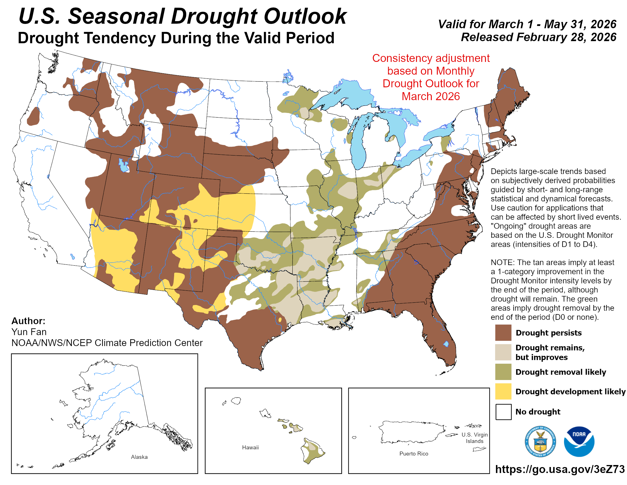
Figure 1. CPC's seasonal drought outlook
Given the outlooks for the spring and historic precedent for a drier than average spring in a transition from La Nina to El Nino (Figure 2), it is not likely that there will be any significant drought relief for the drought affected areas. It is more likely that more of eastern Nebraska goes into drought if April and May are both well below average than we are to see significant drought relief in western, central, and northeastern Nebraska.
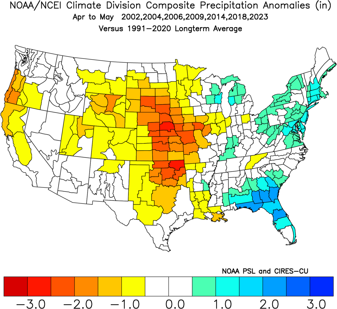
Figure 2. Composite average of precipitation anomalies by climate division in analog years.
We may be faced with a similar situation to last year where many areas are short to very short of moisture at planting. Indeed, the latest ECMWF weeklies shows drier than average favored for pretty much all of Nebraska and the Western Corn Belt and Central Plains in the 30-days up to April 15th. If this verifies, this is bad news for rangelands and it is not good news for future corn, soybean, sorghum, and sugar beet fields that are already short of moisture. This is especially bad news for the winter wheat crop in the southern Panhandle and southwest sections of the state that can't afford a dry spring.
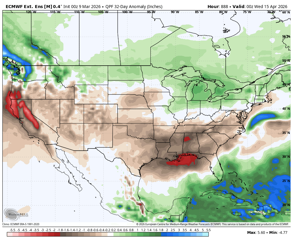
Figure 3. Projected precipitation in the 30-day period ending April 15th
La Nina's death certificate
The Southern Oscillation Index (SOI) is still positive. But the sea surface temperature anomalies in the central and eastern equatorial Pacific and projected westerly wind anomalies at 850 mb in the central Pacific suggests La Nina will likely be officially dead soon. The Pacific Decadal Oscillation (PDO) is still in the negative phase but the water temperatures off the west coast of the U.S. and Canada are not especially cold. The expectation is that warmer water will remain off the west coast through the summer. The Pacific Meridional Mode (PMM) is in its positive phase and is expected to remain positive through the summer.
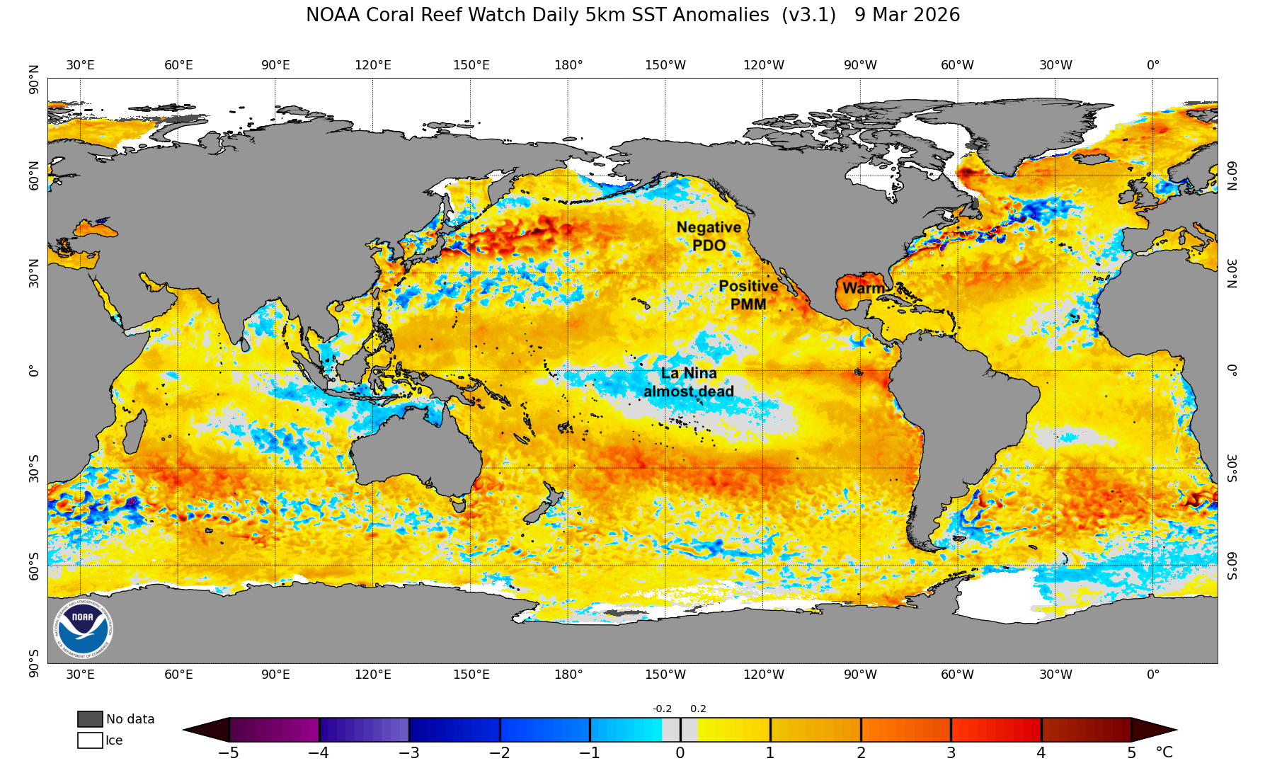
Figure 4. Sea-surface temperature anomalies as of March 9th, 2026.
The summer outlooks from groups like the ECMWF and Columbia University's IRI appear to be weighted toward the likelihood of the combination of El Nino and a positive PMM being in place this summer. That combination generally favors ridging across the western U.S. and more troughing into the central U.S. Ridging also tends to be more prominent off the southeast in a positive PMM mode. Ridging off the southeast coast would lead to more return flow from the Gulf and would mean more routine chances for moisture across most of the north central U.S. Temperatures under such a scenario would generally be mild. In other words, that would be shaping up for a more ideal type summer for much of the Corn Belt.
Summer moisture could be adequate for most
The CPC's summer outlook (Fig. 5) shows below average precipitation is favored in the western half of the state with neither above nor below average favored in the eastern half of the state. However, the current seasonal outlooks from the ECMWF (Fig. 6) and IRI (Fig. 7) show average to above average precipitation for Nebraska and most of the Corn Belt. The ECMWF model outlook is the wettest for Nebraska and the north central U.S. in general. But the IRI model does show a better likelihood of wetter than average in southeast Nebraska.
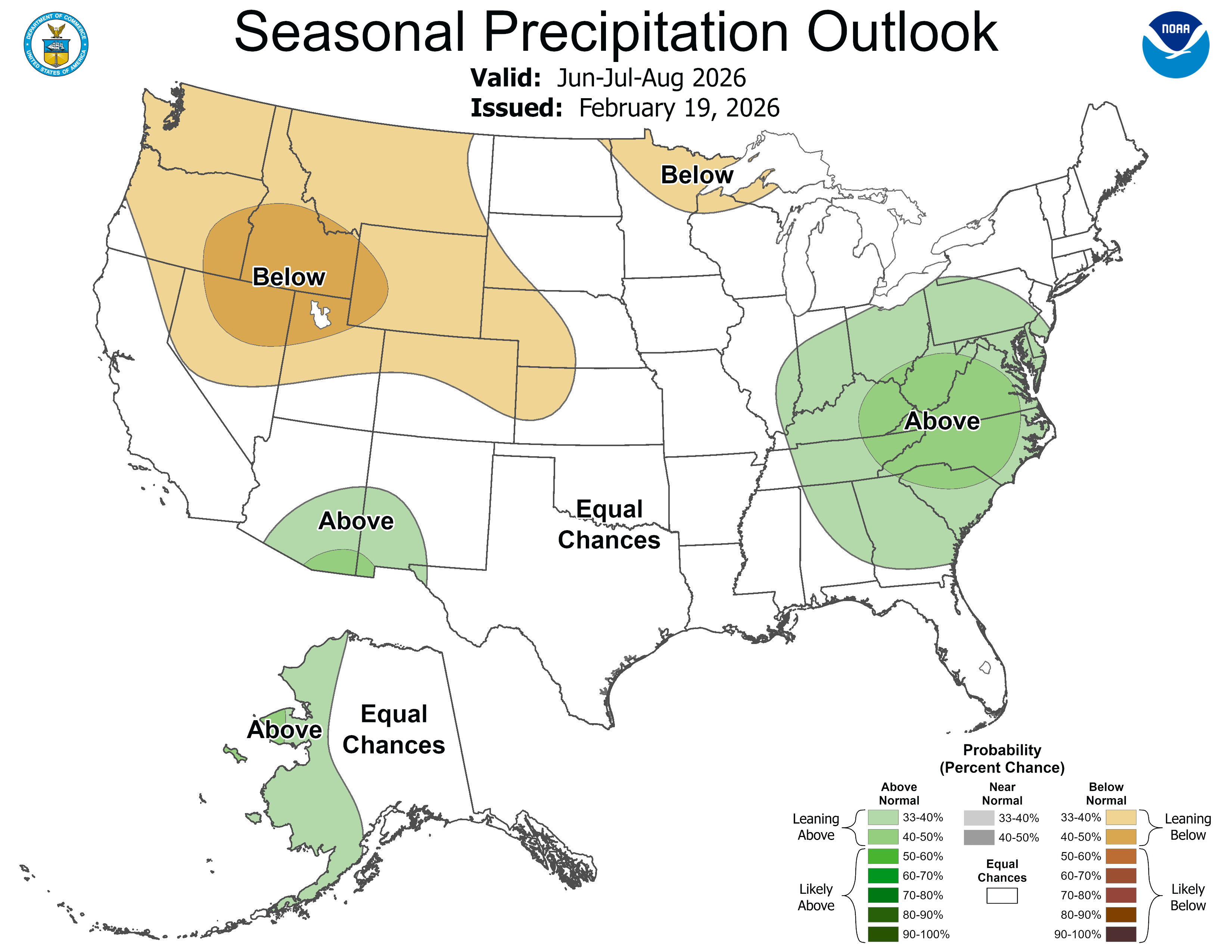
Figure 5. CPC's summer outlook for precipitation
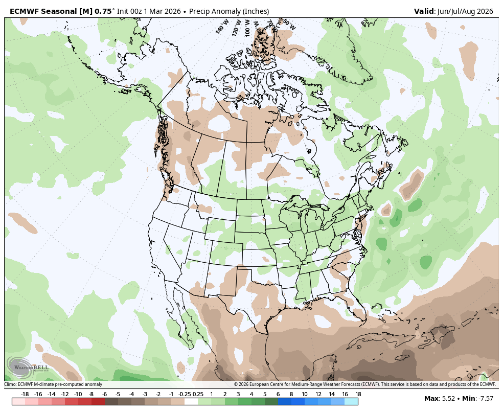
Figure 6. ECMWF projected summer precipitation anomalies
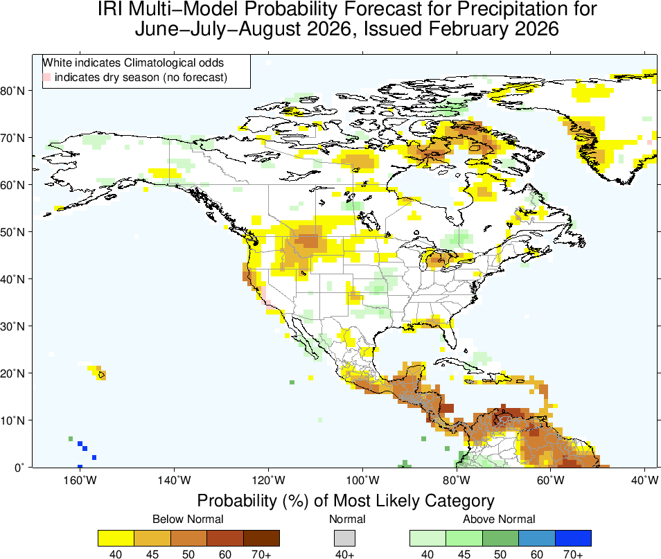
Figure 7. IRI projected summer precipitation anomaly probabilities
The analog summers (2002, 2004, 2006, 2009, 2014, 2015, 2018, 2023) also show average to above average precipitation favored for Nebraska and a majority of the Corn Belt. Drier areas tended to be well north and south of our area. However, the summer of 2002 was very dry (until it was too late) and 2006 wasn't exactly stellar for moisture. Most of these analog years generally brought adequate moisture for a majority of the summer and none brought massive, prolonged drought pressure to the 'I' states. Precipitation in the Mid-South region also tended to be favorable.
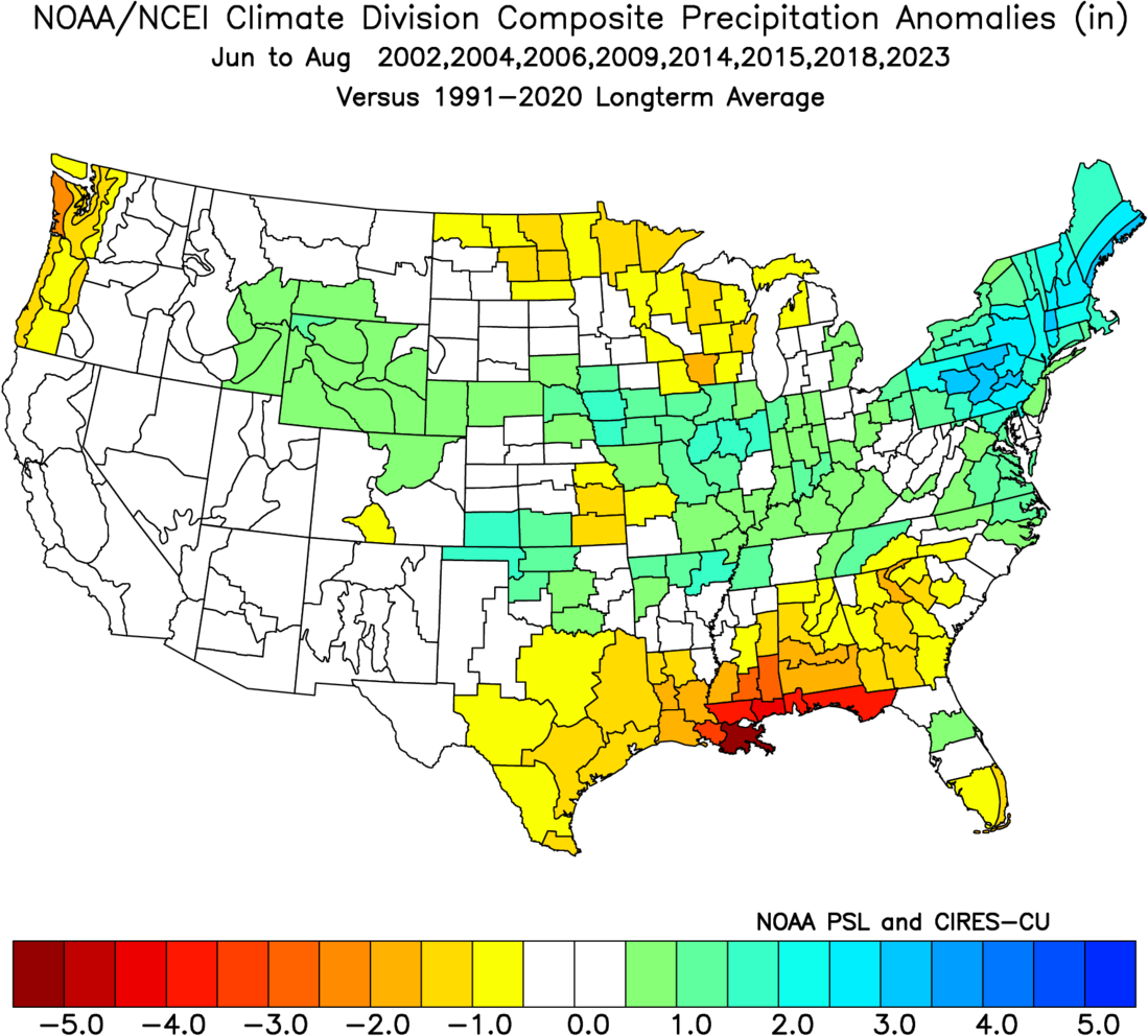
Figure 8. Composite of precipitation anomalies by climate division in the analog summers.
Milder temperatures possible
If El Nino is firmly in place by early summer and a positive PMM is a more dominant signal this summer, the odds of repeated cold fronts that bring cooler, drier air into the north central U.S. would increase. Indeed, the analogs (Fig. 9) would suggest this is a possibility as the composite average is cooler than average for the summer months for all of Nebraska and most of the central U.S. in general. A pattern that brings in cooler, drier air on a regular basis in mid-summer would also be a big help in reducing southern rust pressure. After the past few seasons of intense southern rust pressure, that would be a welcome change.
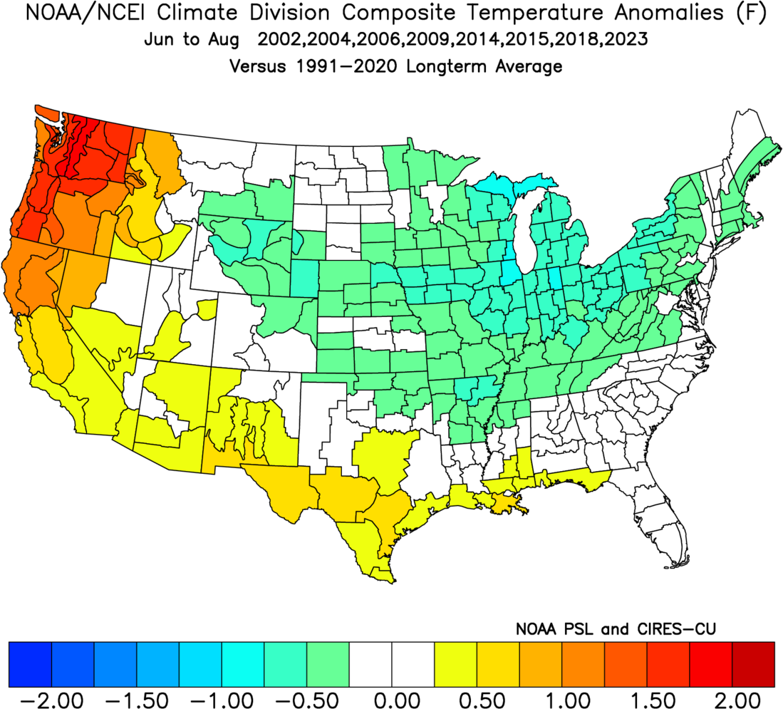
Figure 9. Composite of temperature anomalies by climate division in the analog summers.
The ECMWF model does show slightly above average temperatures favored for most of Nebraska and Iowa. But that also may be baking in a warm June, which is almost a guarantee these days. Still it is worth noting that it shows the strongest warm temperature anomalies being down in Oklahoma/Texas and toward the Pacific Northwest. Historic precedent in years transitioning to El Nino would suggest that if there is going to a massive ridge with long stretches of heat in the U.S., it will be centered well to our south or well to our west.
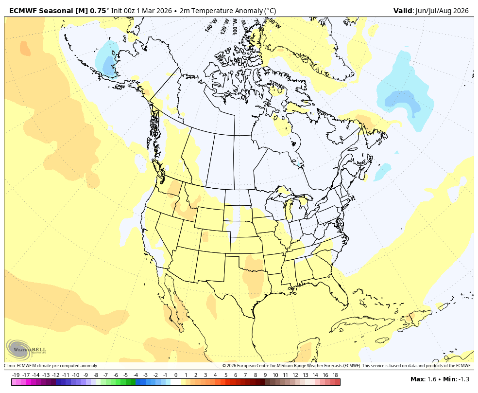
Figure 10. ECMWF projected summer temperature anomalies
The CPC does show warmer than average favored for the entire country with stronger likelihoods across western Nebraska into the western U.S. This also may just be favoring recent climatology where the western part of Nebraska and the western U.S. have had even stronger warming signals in the summer than eastern Nebraska and much of the Corn Belt.
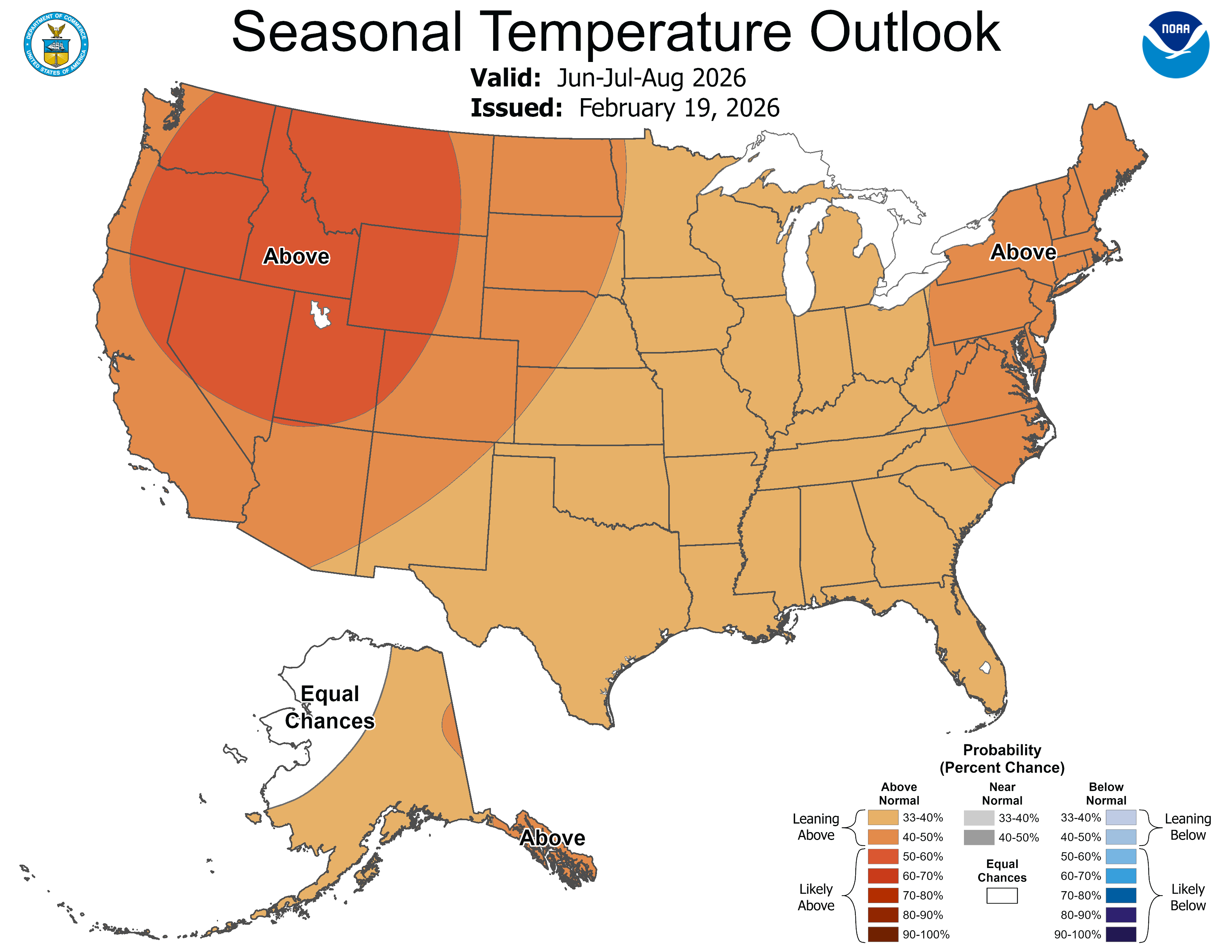
Figure 11. CPC summer temperature outlook
Possible worst case scenario for western Nebraska
It is worth considering that the CPC is also showing a drier than average signal in the western part of the state (Fig. 11). With water flow on the North and South Platte Rivers likely to be well below average and severe to extreme drought already in place, there is a possibility that the Panhandle, Sand Hills, and southwest sections of the state could be facing the worst growing season so far in the 21st century. A couple of good, soaking rains this spring would go a long way to helping avoid that.
The central and northeast sections of the state also would be facing challenging conditions if the CPC's outlooks of above average summer temperatures and only average precipitation summer precipitation follow a dry April and May. 2023 is considered an analog more for its ENSO context. But it is worth considering that areas between Highways 281 and 15 may be facing something another situation like 2023 where the faucet turns on a few weeks too late.
Southeast Nebraska is in the best shape currently and has an outlook that generally would be viewed as neutral to positive for the coming season. This area can't afford 2023 levels of spring dryness either but a somewhat drier than average April and May won't set this area back nearly as bad as the rest of the state if moisture is adequate this summer.
Most of the Corn Belt has an outlook that I would classify as largely favorable for corn and soybean production. Biggest caveat will be decent improvement in drought conditions from Champaign into western Ohio. If that area gets improvement as expected, it seems likely that the 'I' states are setting themselves up for a nice growing season.


