Warm weekend and start to next week ahead
A strong upper level ridge will be dominant the next several days and will keep the entire state dry and warm.
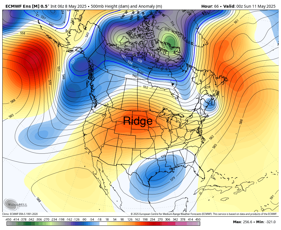
Figure 1. 500-mb height anomalies
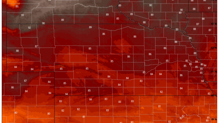
Temperatures will warm up a bit more tomorrow compared to today and then will shoot up another 3-6°F on Saturday. Highs in the 80's will prevail statewide and may get close to 90°F in northeast Nebraska. Sunday will see temperatures drop off just slightly in the southern half of the state but likely will be even warmer in the northern part of the state where mixing of warmer air aloft will be optimal. Highs in the lower 90's are likely across the northern Panhandle. Given the long-term drought conditions that prevail across much of the northwestern part of the state, it is possible that those temperatures are a bit under forecast.
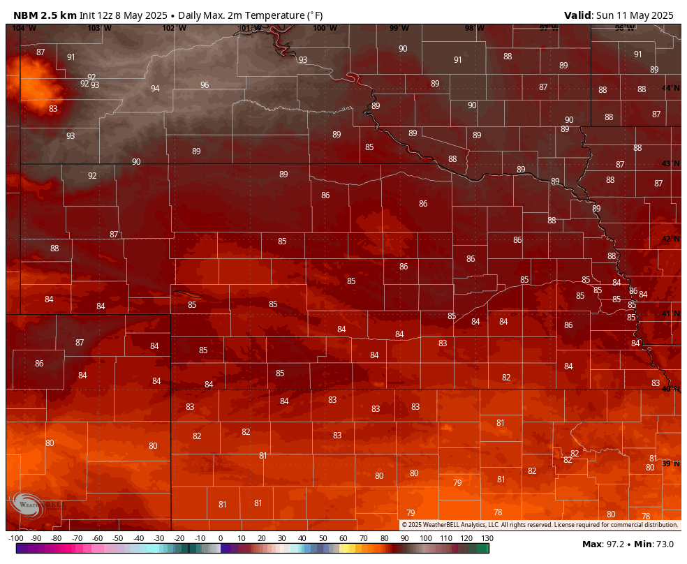
Figure 2. Projected high temperatures on Sunday
Fire danger
Winds will pick up from the south on Saturday in western Nebraska and on Sunday further east. It will remain breezy from the south to southwest statewide through Tuesday. Sustained winds over 20 mph look probable across most of the Sand Hills on Sunday and Monday. With lower relative humidity and stressed vegetation, fire danger will be elevated. The burn ban expires on Sunday across the western two-thirds of the state but extreme caution is still advised. It is possible that Governor Pillen may extend the burn ban for another week for some areas. Danger is a bit less in eastern Nebraska where it has rained more this spring and vegetation is healthier. But with breezy conditions and low RH in the afternoon hours, controlled burns would not be advised in the eastern part of the state and are strongly discouraged between in areas in severe to extreme drought.
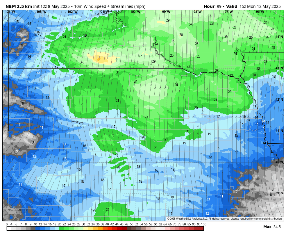
Figure 3. Sustained wind speeds on Monday
Cooling off late week. Storm chances in Panhandle
It will remain warm statewide Monday and Tuesday with temperatures generally running 85-90°F statewide. Might be a bit warmer in the northern Panhandle on Monday and will likely be under 85°F in the southeast corner of the state. As we get to Wednesday, a trough in the western U.S. will move into the Northern Plains and at the surface a cold front will be moving through the state.
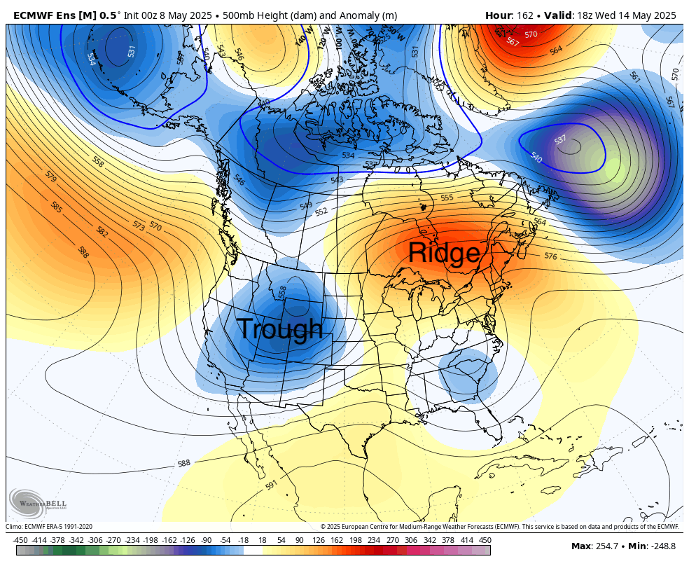
Figure 4. 500-mb height anomalies on Wednesday
Ahead of the front temperatures will be well above average, likely pushing 90°F or a little higher in the eastern half of the state. Behind the front more seasonal temperatures in the upper 60's to mid 70's will be common. The best atmospheric forcing (rising motion) to produce showers and storms will be north of the state and the trough off the southeast coast means moisture return to the High Plains will not be optimal. Nevertheless, the Panhandle and northwest Sand Hills should see a reasonable chance for moisture on Tuesday night into Wednesday morning.
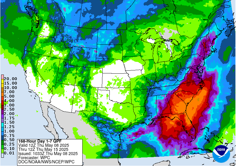
Figure 5. WPC projected precipitation amounts through next Thursday morning
The WPC shows a possibility of getting an inch from Hay Springs to Chadron and the ECMWF shows some probability of a half inch of moisture, which would be very welcome if it came to fruition. But if that trough off the southeast hinders moisture return to that area, amounts are more likely to be in the 0.10-0.33" range. Better than nothing but not drought busting rain. Storms may go up later Wednesday along the front in eastern Nebraska but between sub-optimal moisture return and elevated temperatures aloft, the front likely will go through most of the state dry. Best chance at getting moisture on Wednesday afternoon/evening would be across the northeast corner where convergence will be better.
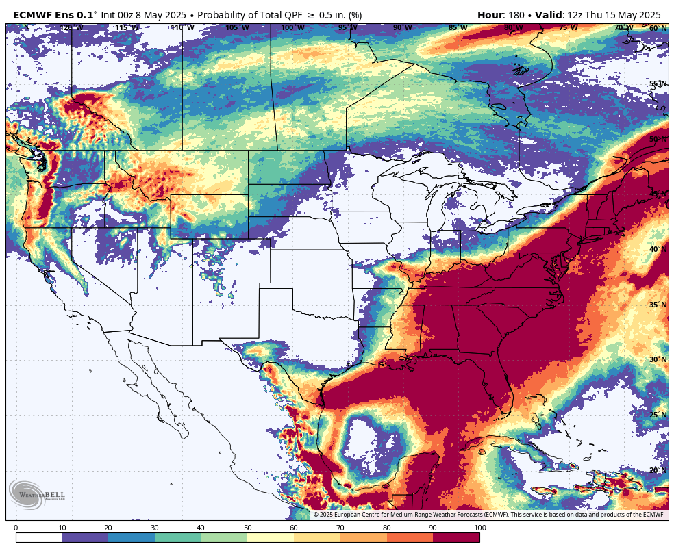
Figure 6. ECMWF probability of a half inch of moisture through next Thursday morning
After the front passes the last part of the week will be more seasonal with temperatures in the 60's and 70's. Thursday and Friday should be dry statewide and may be a bit breezy. Another trough, perhaps a potent one, will be coming into the central U.S. next weekend.
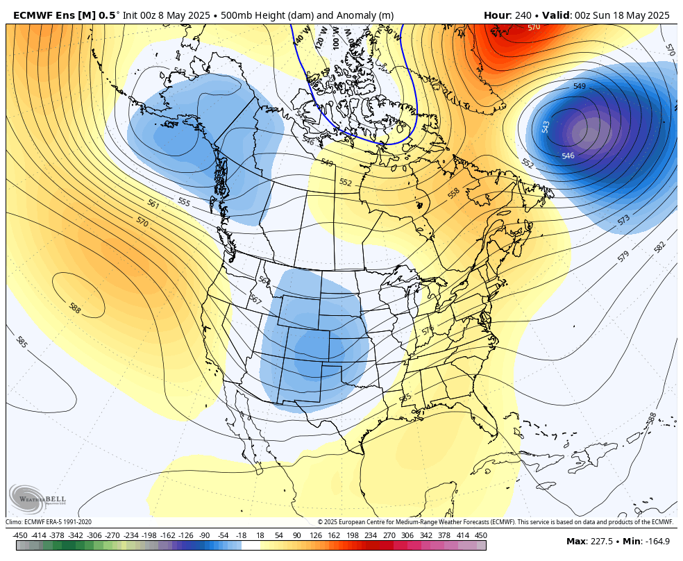
Figure 7. 500-mb height anomalies next Saturday evening
This would increase rain chances for the state, particularly for central and eastern sections of the state. Severe weather may be possible on Saturday afternoon into Sunday morning and it is possible that significant precipitation may fall in the eastern half of the state next weekend. Too early to get super excited about moisture prospects but things are lining up for the possibility of getting much needed moisture in the region next weekend. The CPC does have the entire state and region leaning above average on precipitation in the 8-14 day outlook.
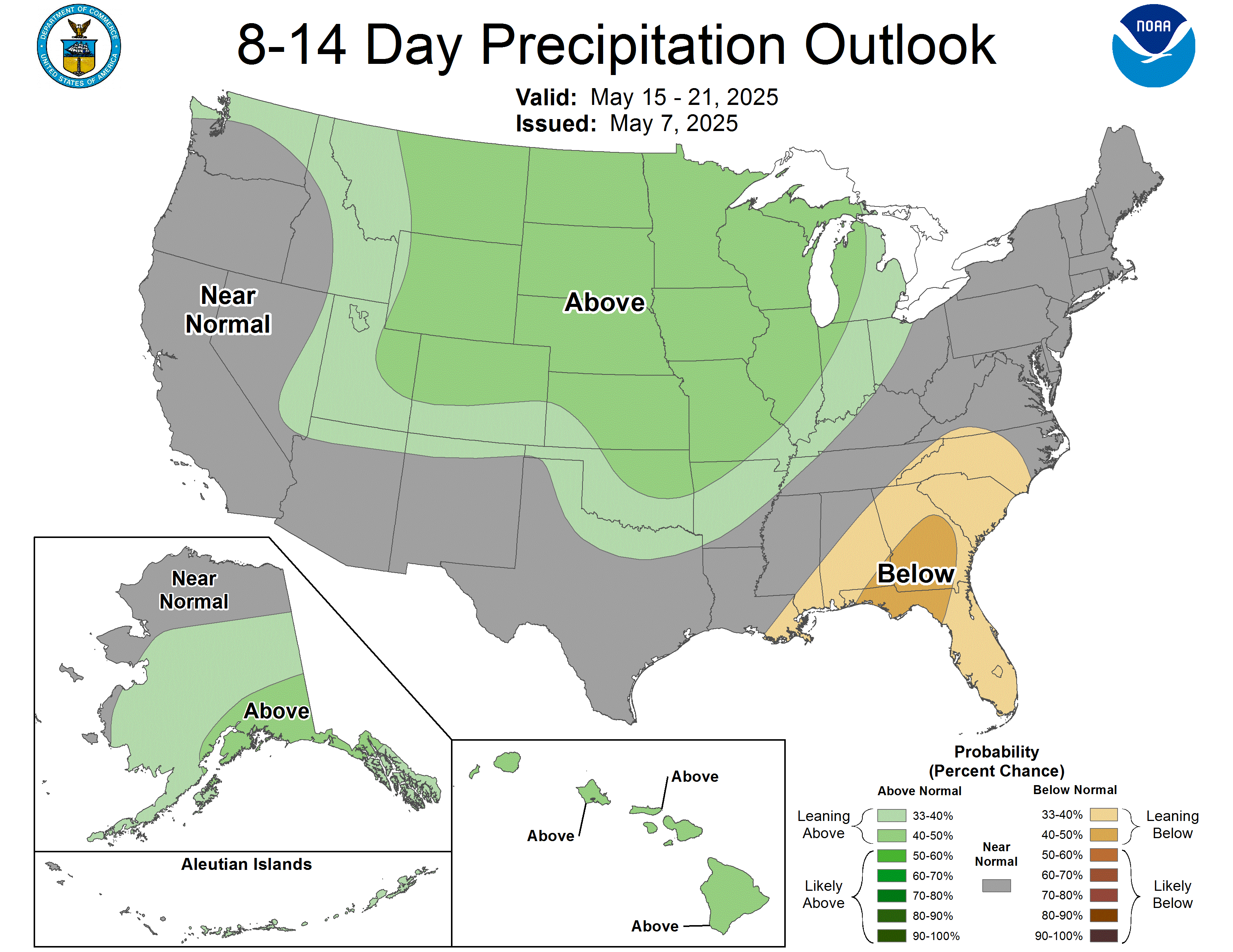
Figure 8. CPC's 8-14 day precipitation outlook
It also is looking likely to cool back down to seasonal and possibly to below seasonal temperatures the week after next, especially for afternoon high temperatures if that upper level low is slow to exit the region and cloud cover is extensive. Additional precipitation may be possible the middle of the week after next as well. This would be very welcome as drought conditions across the state are getting worse quickly (see related links article).
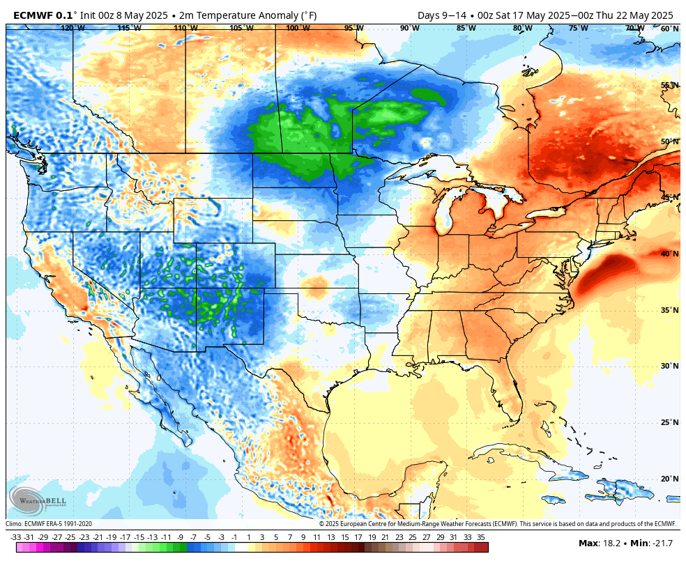
Figure 9. ECMWF ensemble projected temperature anomalies between May 18-22.


