Warm week; cool finish
It was one of the warmer weeks of this summer for most with many locations outside northeast Nebraska having multiple days in the 90's. The culprit was a ridge anchored over the southwestern U.S. that kept the state on the northeastern side of the warmer temperatures for most of the week (Figure 1), especially in western Nebraska where air temperatures got into the lower 100's.
A look at the 850-mb anomalies (Figure 2) also help explain the warmer temperatures. As is the case under and near a ridge, the atmosphere is warmer and 850-mb anomalies averaged 2-3°C warmer than average over most of the state last week. Mixing was better in western Nebraska (and 850-mb is closer to the surface in the Panhandle), so air temperatures were warmer than further east. The pocket of cool anomalies at 850-mb shown in western Canada in Figure 2 had slid into our region by the end of the week as that trough made its way to the Great Lakes and the southern ridge flattened.
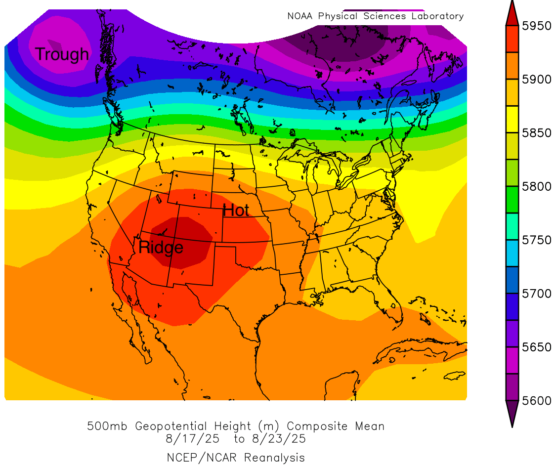
Figure 1. Average 500-mb heights last week
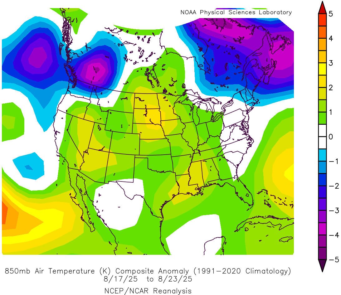
Figure 2. 850-mb temperature anomalies
A cold front moved through the state on Friday in association with the deeper upper level trough over the Great Lakes region. Temperatures were much cooler behind the front with highs in the 70's statewide. For the eastern half of Nebraska, the cold front also brought in relief from the higher dew points and higher minimum temperatures that had been in place for the previous 10 days.
Drier week
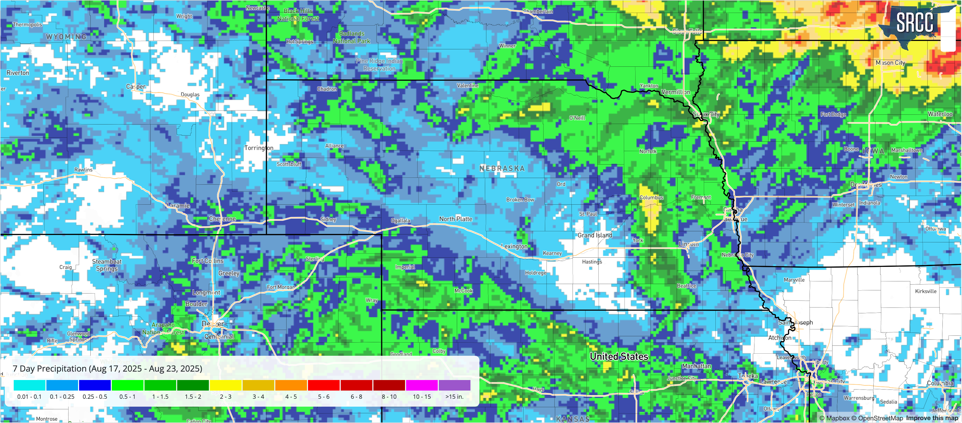
Most of the state was reasonably dry last week with a large pocket of south central Nebraska receiving no precipitation. But there was some rain elsewhere, especially was across the northeast quadrant of the state down through Columbus and Stromsburg on the morning of Monday the 18th. Flash flood warnings were issued in Platte County as over 3" fell in less than an hour in spots. There were additional storms in eastern Nebraska on Friday afternoon that produced some damage around Dorchester and southwest Nebraska received some precipitation on Friday night into Saturday morning.
Temperature and Precipitation Extremes
Maximum High Temperature: 101°F, Chadron 3 SW
Minimum High Temperature: 66°F, Bushnell 15 S
Minimum Low Temperature: 45°F, Agate 3 E
Maximum Low Temperature: 77°F, Valley NWS
Maximum Precipitation: 3.63", Platte Center 3.78 SSE
Mesonet Station Summary
The table below shows maximum temperature, minimum temperature, average temperature, the number of days with maximum temperatures ≥95°F, minimum temperatures ≥70°F, total precipitation, growing/heating/cooling degree days, and average daily potential ET for the Nebraska Mesonet stations. Here are the temperature and precipitation extremes from last week:
| station | MaxT | MinT | AvgT | >95F | >70F+ | Prcp | GDD | CDD | HDD | pET |
| Alda 5NW | 92 | 61 | 77.1 | 0 | 2 | 0.00 | 179 | 85 | 0 | 1.61 |
| Alliance 6NW | 97 | 55 | 73.1 | 1 | 0 | 0.13 | 140 | 57 | 0 | 2.05 |
| Arthur 8S | 95 | 54 | 74.0 | 0 | 0 | 0.00 | 147 | 63 | 0 | 2.08 |
| Axtell 5NE | 91 | 62 | 77.7 | 0 | 1 | 0.00 | 176 | 89 | 0 | 1.55 |
| Big Springs 6SE | 94 | 57 | 74.7 | 0 | 0 | 0.27 | 159 | 68 | 0 | 2.01 |
| Big Springs 8NE | 94 | 56 | 74.4 | 0 | 0 | 0.06 | 152 | 66 | 0 | 2.05 |
| Broadwater 7N | 96 | 56 | 73.8 | 1 | 0 | 0.00 | 145 | 62 | 0 | 2.12 |
| Bushnell 12SE | 91 | 55 | 71.0 | 0 | 0 | 0.00 | 140 | 43 | 1 | 2.17 |
| Central City 3W | 90 | 60 | 76.7 | 0 | 2 | 0.00 | 177 | 82 | 0 | 1.52 |
| Concord 2E | 87 | 55 | 73.6 | 0 | 1 | 0.24 | 159 | 62 | 2 | 1.19 |
| Cook 4SW | 92 | 59 | 77.3 | 0 | 3 | 0.03 | 181 | 86 | 0 | 1.59 |
| Decatur 7S | 90 | 54 | 75.3 | 0 | 2 | 0.44 | 171 | 74 | 2 | 1.26 |
| Dickens 1NE | 93 | 57 | 75.0 | 0 | 0 | 0.14 | 160 | 70 | 0 | 1.79 |
| Eagle 3NW Beta | 91 | 53 | 75.9 | 0 | 1 | 0.04 | 172 | 77 | 1 | 1.42 |
| Emmet 2E | 92 | 56 | 75.1 | 0 | 1 | 0.71 | 165 | 71 | 0 | 1.47 |
| Enders 10SW | 95 | 59 | 76.8 | 0 | 0 | 0.91 | 163 | 83 | 0 | 2.25 |
| Firth 3N | 90 | 61 | 77.7 | 0 | 3 | 0.08 | 184 | 89 | 0 | 1.45 |
| Fordyce 4N | 87 | 58 | 74.4 | 0 | 1 | 2.03 | 166 | 66 | 1 | 1.27 |
| Gothenburg 2NW | 92 | 58 | 76.2 | 0 | 1 | 0.00 | 169 | 78 | 0 | 1.65 |
| Guide Rock 3E | 93 | 64 | 78.9 | 0 | 3 | 0.00 | 182 | 97 | 0 | 1.74 |
| Harrisburg 1N | 95 | 55 | 73.9 | 1 | 0 | 0.01 | 153 | 62 | 0 | 2.28 |
| Harvard 4SW | 89 | 63 | 76.4 | 0 | 1 | 0.00 | 175 | 80 | 0 | 1.43 |
| Hayes Center 3N | 94 | 60 | 76.1 | 0 | 0 | 0.55 | 165 | 78 | 0 | 1.84 |
| Holdrege 5N | 91 | 61 | 77.5 | 0 | 1 | 0.00 | 178 | 87 | 0 | 1.64 |
| Indianola 8SW | 95 | 63 | 78.5 | 2 | 1 | 0.48 | 171 | 95 | 0 | 2.20 |
| Kearney 3E | 92 | 62 | 77.9 | 0 | 2 | 0.00 | 179 | 90 | 0 | 1.78 |
| Keystone 4W | 94 | 57 | 75.1 | 0 | 0 | 0.00 | 158 | 70 | 0 | 2.14 |
| Leigh 1W | 90 | 57 | 75.4 | 0 | 1 | 1.08 | 170 | 72 | 0 | 1.40 |
| Lexington 4S | 92 | 60 | 77.2 | 0 | 1 | 0.00 | 177 | 85 | 0 | 1.63 |
| Lincoln 1500 N 45th | 93 | 60 | 79.0 | 0 | 4 | 0.06 | 188 | 98 | 0 | 1.44 |
| Long Pine 20S | 94 | 53 | 74.4 | 0 | 0 | 0.26 | 157 | 67 | 1 | 1.86 |
| Memphis 4N | 91 | 58 | 76.5 | 0 | 1 | 0.83 | 175 | 81 | 0 | 1.39 |
| Memphis 5N | 90 | 57 | 76.1 | 0 | 1 | 0.89 | 174 | 78 | 0 | 1.41 |
| Merna 2SW | 93 | 55 | 75.2 | 0 | 0 | 0.00 | 161 | 72 | 0 | 1.35 |
| Naper 12SW | 94 | 54 | 76.2 | 0 | 1 | 0.00 | 168 | 79 | 0 | 1.93 |
| Nebraska City 3W | 88 | 60 | 78.0 | 0 | 5 | 0.52 | 190 | 91 | 0 | 1.40 |
| North Platte 3SW Beta | 94 | 56 | 74.4 | 0 | 0 | 0.00 | 153 | 66 | 0 | 1.62 |
| Oakland 4W | 90 | 56 | 75.4 | 0 | 1 | 1.54 | 171 | 73 | 1 | 1.24 |
| Ord 2N | 90 | 58 | 76.1 | 0 | 2 | 0.02 | 173 | 77 | 0 | 1.38 |
| Oshkosh 6N | 96 | 56 | 75.5 | 1 | 0 | 0.01 | 156 | 74 | 0 | 2.45 |
| Overton 6SE | 91 | 60 | 76.3 | 0 | 1 | 0.00 | 169 | 79 | 0 | 1.52 |
| Pierce 2SW | 87 | 57 | 74.5 | 0 | 1 | 0.44 | 166 | 67 | 0 | 1.33 |
| Plattsmouth 2SE | 90 | 61 | 76.8 | 0 | 4 | 0.16 | 180 | 82 | 0 | 1.35 |
| Rulo 5SW | 92 | 59 | 77.3 | 0 | 3 | 0.01 | 181 | 86 | 0 | 1.50 |
| Scottsbluff 2NW | 97 | 56 | 75.3 | 1 | 0 | 0.00 | 153 | 72 | 0 | 2.07 |
| Scottsbluff 6NW | 93 | 54 | 73.8 | 0 | 0 | 0.36 | 150 | 62 | 0 | 1.88 |
| Shelton 2SW | 92 | 61 | 77.4 | 0 | 0 | 0.00 | 176 | 87 | 0 | 1.48 |
| Sidney 2NW | 96 | 56 | 73.5 | 1 | 0 | 0.12 | 144 | 60 | 0 | 2.18 |
| Smithfield 2E | 91 | 60 | 76.8 | 0 | 0 | 0.01 | 175 | 83 | 0 | 1.54 |
| Valparaiso 6NW | 88 | 58 | 76.5 | 0 | 3 | 0.49 | 179 | 80 | 0 | 1.36 |
| Walton 5NW | 92 | 60 | 78.7 | 0 | 4 | 0.08 | 186 | 96 | 0 | 1.47 |
| Whitman 5NE | 94 | 51 | 72.5 | 0 | 0 | 0.15 | 135 | 52 | 0 | 1.78 |
| Winslow 6E | 90 | 56 | 75.5 | 0 | 1 | 0.71 | 172 | 74 | 1 | 1.95 |
| Wood River 5SE | 90 | 62 | 76.8 | 0 | 0 | 0.00 | 175 | 83 | 0 | 1.54 |
| York 2W | 90 | 62 | 77.3 | 0 | 2 | 0.47 | 179 | 86 | 0 | 1.31 |