
Heat then cooler weather
The week began with temperatures in the 90's statewide, with heat advisories in central Nebraska and excessive heat warnings in eastern Nebraska. The combination of heat and dewpoints in the 70's (central NE) and upper 70's to lower 80's (eastern NE) led to very high heat index values early in the week during the afternoon and early evening hours (Figure 1). Air temperatures peaked in western and northern sections of the state on Monday with temperatures getting into the lower 100's in southwest Nebraska. Dewpoints in the 20's to 50's helped keep heat index values below heat advisory criteria in western Nebraska.
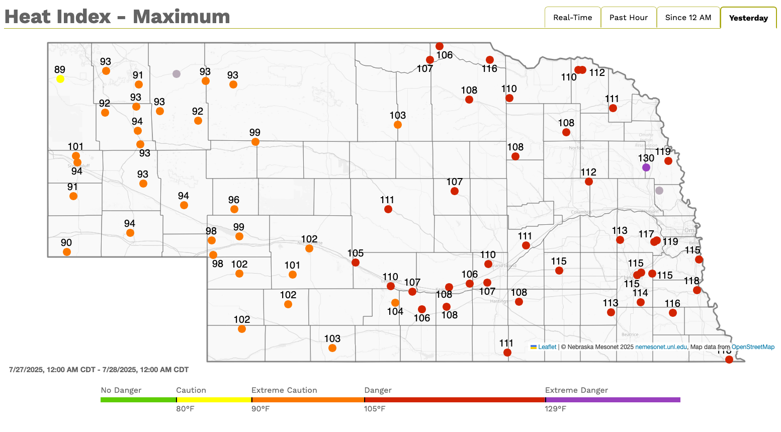
Figure 1. Maximum heat index values at Mesonet sites across the state last Sunday
The ridge anchored over the southern U.S. began to break down and a trough moving through eastern Canada helped drive a cold front into the region early in the week (Figure 2).
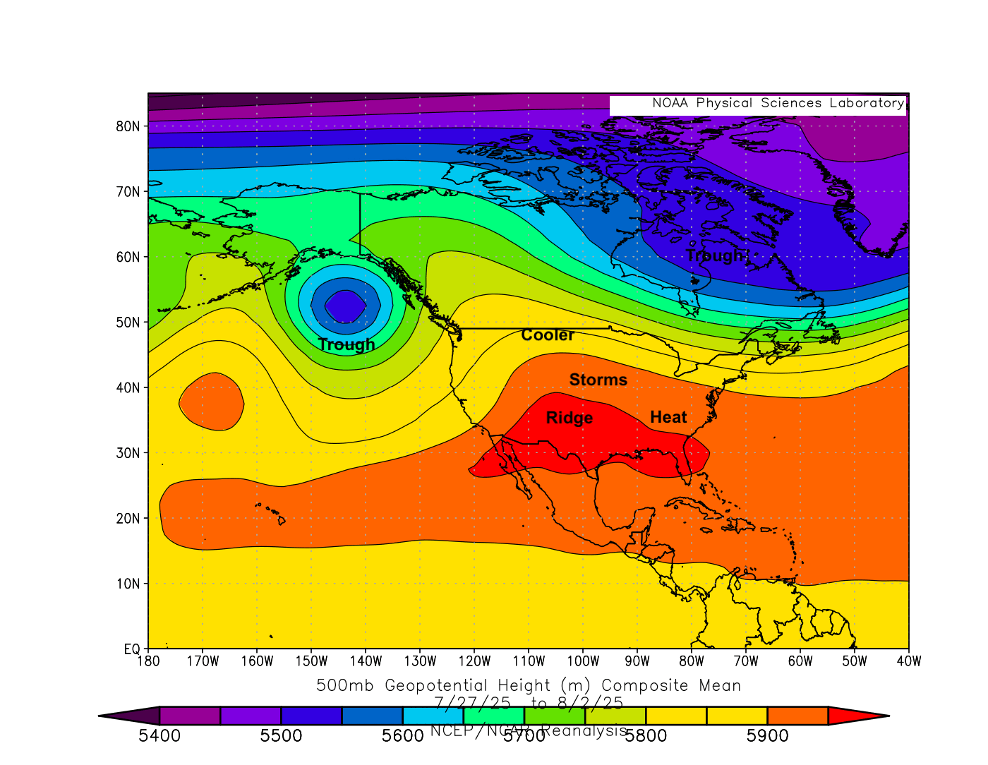
Figure 2. 500-mb heights last week.
Temperatures were sharply cooler in western Nebraska behind the front and it managed to cleared the state by early Wednesday. The front was a focal point for showers and storms across the state with many areas receiving over an inch of moisture. Pockets of central and northeast Nebraska received over 2" and there were isolated reports of wind damage in eastern Nebraska from Tuesday night's storms. Additional showers and storms developed later Wednesday night in extreme eastern Nebraska, with over 4" falling in west Omaha. Flash flooding was reported. Precipitation totals from last week are shown in Figure 3.
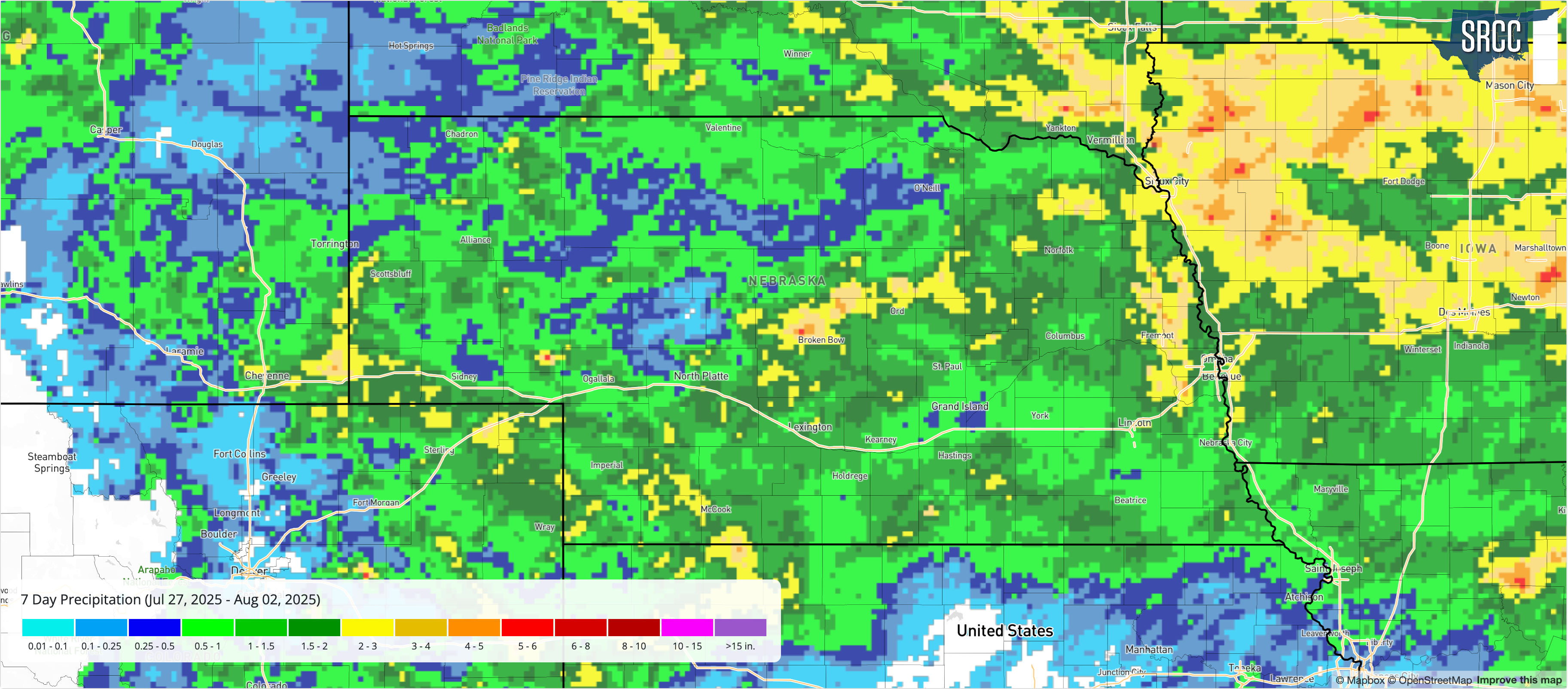
Figure 3. Precipitation totals last week across the state. Figure courtesy of the Southern Regional Climate Center.
Seasonally cool temperatures were the rule the remainder of the week after the frontal passage, especially in central and eastern Nebraska where cloud cover and smoke/haze helped keep afternoon temperatures in the 70's. Many locations in the eastern half of the state had their first sub-60°F low temperature in almost three weeks- welcomed after a long stretch of warm nights.
The table below shows maximum temperature, minimum temperature, average temperature, the number of days with maximum temperatures ≥95°F, minimum temperatures ≥70°F, total precipitation, growing/heating/cooling degree days, and average daily potential ET for the Nebraska Mesonet stations. Here are the temperature and precipitation extremes from last week:
Maximum High Temperature: 105°F, Imperial Municipal Airport
Minimum High Temperature: 70°F, Elgin
Minimum Low Temperature: 47°F, Harrison 20 SSE
Maximum Low Temperature: 77°F, Nebraska City 2 NW
Maximum Precipitation: 5.19", Elkhorn 5.7 S
| station | MaxT | MinT | AvgT | >95F | >70F+ | Prcp | GDD | CDD | HDD | pET |
| Alda 5NW | 94 | 60 | 74.9 | 0 | 2 | 0.78 | 158 | 69 | 0 | 1.56 |
| Alliance 6NW | 98 | 52 | 71.0 | 2 | 0 | 0.32 | 131 | 42 | 0 | 1.74 |
| Arthur 8S | 100 | 58 | 72.6 | 2 | 0 | 1.07 | 143 | 53 | 0 | 1.80 |
| Axtell 5NE | 96 | 59 | 74.7 | 2 | 1 | 1.34 | 154 | 68 | 0 | 1.47 |
| Big Springs 6SE | 102 | 60 | 74.6 | 2 | 0 | 0.37 | 155 | 67 | 0 | 1.97 |
| Big Springs 8NE | 101 | 58 | 73.7 | 2 | 0 | 0.35 | 149 | 61 | 0 | 1.89 |
| Broadwater 7N | 97 | 55 | 72.2 | 2 | 0 | 0.00 | 142 | 50 | 0 | 1.76 |
| Bushnell 12SE | 97 | 54 | 71.1 | 2 | 0 | 0.26 | 134 | 43 | 0 | 2.28 |
| Central City 3W | 92 | 58 | 74.2 | 0 | 2 | 0.52 | 157 | 64 | 0 | 1.46 |
| Concord 2E | 90 | 55 | 71.9 | 0 | 1 | 2.08 | 145 | 49 | 1 | 1.30 |
| Cook 4SW | 93 | 59 | 75.1 | 0 | 3 | 0.44 | 162 | 71 | 0 | 1.37 |
| Decatur 7S | 92 | 55 | 73.8 | 0 | 1 | 2.51 | 154 | 62 | 0 | 1.39 |
| Dickens 1NE | 102 | 58 | 74.7 | 2 | 0 | 1.34 | 153 | 68 | 0 | 1.87 |
| Eagle 3NW Beta | 96 | 54 | 75.1 | 2 | 3 | 1.17 | 160 | 71 | 0 | 1.43 |
| Emmet 2E | 95 | 59 | 73.6 | 0 | 2 | 0.18 | 153 | 60 | 0 | 1.59 |
| Enders 10SW | 105 | 58 | 76.0 | 2 | 0 | 0.29 | 158 | 77 | 0 | 2.16 |
| Firth 3N | 93 | 55 | 74.5 | 0 | 3 | 0.62 | 158 | 66 | 0 | 1.35 |
| Fordyce 4N | 92 | 57 | 72.7 | 0 | 1 | 0.61 | 151 | 54 | 0 | 1.44 |
| Gothenburg 2NW | 97 | 60 | 74.6 | 2 | 0 | 1.20 | 156 | 67 | 0 | 1.73 |
| Guide Rock 3E | 97 | 58 | 76.2 | 3 | 2 | 0.51 | 163 | 78 | 0 | 1.70 |
| Harrisburg 1N | 97 | 58 | 71.4 | 2 | 0 | 1.69 | 136 | 45 | 0 | 2.07 |
| Harvard 4SW | 94 | 58 | 73.9 | 0 | 2 | 1.45 | 152 | 63 | 0 | 1.42 |
| Hayes Center 3N | 103 | 58 | 75.3 | 3 | 0 | 3.14 | 154 | 72 | 0 | 1.85 |
| Holdrege 5N | 95 | 60 | 74.8 | 1 | 1 | 1.10 | 155 | 68 | 0 | 1.61 |
| Indianola 8SW | 101 | 61 | 76.4 | 3 | 1 | 1.13 | 161 | 79 | 0 | 2.21 |
| Kearney 3E | 96 | 59 | 75.0 | 3 | 2 | 1.01 | 157 | 70 | 0 | 1.67 |
| Keystone 4W | 102 | 59 | 73.9 | 2 | 0 | 1.99 | 150 | 62 | 0 | 1.88 |
| Leigh 1W | 92 | 57 | 73.3 | 0 | 1 | 1.52 | 152 | 58 | 0 | 1.43 |
| Lexington 4S | 94 | 60 | 74.5 | 0 | 2 | 1.10 | 157 | 67 | 0 | 1.53 |
| Lincoln 1500 N 45th | 97 | 56 | 76.2 | 3 | 3 | 0.65 | 165 | 79 | 0 | 1.39 |
| Long Pine 20S | 95 | 59 | 72.7 | 0 | 1 | 0.22 | 148 | 54 | 0 | 1.67 |
| Memphis 4N | 94 | 55 | 74.6 | 0 | 3 | 2.26 | 158 | 67 | 0 | 1.38 |
| Memphis 5N | 94 | 55 | 74.5 | 0 | 3 | 2.20 | 156 | 67 | 0 | 1.38 |
| Merna 2SW | 93 | 59 | 72.7 | 0 | 0 | 1.89 | 147 | 54 | 0 | 1.29 |
| Naper 12SW | 96 | 59 | 73.1 | 1 | 0 | 0.00 | 150 | 57 | 0 | 1.63 |
| Nebraska City 3W | 92 | 59 | 75.0 | 0 | 3 | 0.94 | 163 | 70 | 0 | 1.28 |
| North Platte 3SW Beta | 102 | 59 | 75.1 | 2 | 0 | 2.39 | 155 | 71 | 0 | 1.74 |
| Oakland 4W | 92 | 55 | 73.3 | 0 | 0 | 1.82 | 151 | 59 | 0 | 1.29 |
| Ord 2N | 94 | 60 | 74.3 | 0 | 1 | 0.86 | 157 | 65 | 0 | 1.64 |
| Oshkosh 6N | 99 | 57 | 73.2 | 2 | 0 | 0.35 | 147 | 57 | 0 | 2.03 |
| Overton 6SE | 93 | 59 | 74.2 | 0 | 0 | 1.14 | 156 | 64 | 0 | 1.44 |
| Pierce 2SW | 91 | 57 | 72.7 | 0 | 1 | 1.55 | 151 | 54 | 0 | 1.48 |
| Plattsmouth 2SE | 92 | 57 | 74.8 | 0 | 3 | 1.08 | 162 | 69 | 0 | 1.36 |
| Rulo 5SW | 94 | 58 | 75.7 | 0 | 3 | 0.53 | 167 | 75 | 0 | 1.36 |
| Scottsbluff 2NW | 96 | 56 | 71.5 | 2 | 0 | 0.74 | 138 | 46 | 0 | 1.62 |
| Scottsbluff 6NW | 93 | 56 | 70.9 | 0 | 0 | 0.96 | 134 | 41 | 0 | 1.58 |
| Shelton 2SW | 94 | 59 | 73.9 | 0 | 2 | 0.37 | 155 | 62 | 0 | 1.37 |
| Sidney 2NW | 98 | 54 | 72.4 | 2 | 0 | 0.44 | 141 | 52 | 0 | 1.98 |
| Smithfield 2E | 93 | 59 | 73.8 | 0 | 1 | 1.27 | 155 | 62 | 0 | 1.47 |
| Valparaiso 6NW | 93 | 60 | 73.9 | 0 | 2 | 1.29 | 154 | 63 | 0 | 1.35 |
| Walton 5NW | 97 | 58 | 76.0 | 3 | 3 | 1.97 | 162 | 77 | 0 | 1.51 |
| Whitman 5NE | 98 | 56 | 72.5 | 2 | 0 | 0.10 | 144 | 53 | 0 | 1.78 |
| Wood River 5SE | 93 | 59 | 73.9 | 0 | 2 | 1.06 | 154 | 62 | 0 | 1.44 |
| York 2W | 94 | 57 | 74.8 | 0 | 2 | 0.85 | 160 | 69 | 0 | 1.28 |


