
Heat, storms, and heavy rain
The week began with seasonally cool temperatures and scattered showers and storms across southwest Nebraska and the Highway 81 corridor, with an area of heavy rainfall in eastern Knox County on Sunday. An observer just south of Bloomfield had over 4" last Sunday and almost 8.50" for the week. Additional showers and storms affected the eastern side of the state on Monday. Total precipitation for last week is shown below in Figure 1.
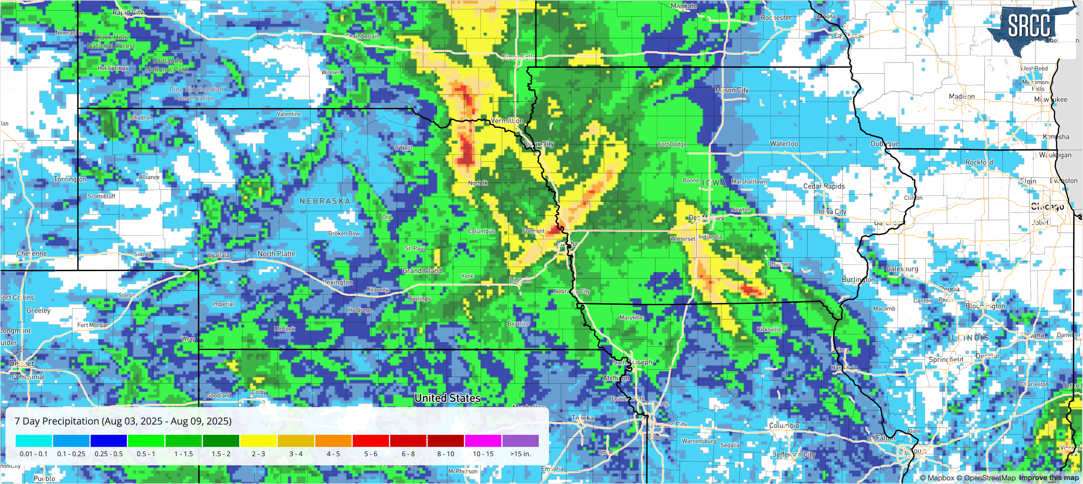
Figure 1. Total precipitation for the week ending August 9th
Temperatures began to warm up early in the week in the Panhandle with highs in the 90's starting on Tuesday as a southwest ridge began to build north. A complex of storms rolled around the ridge late Tuesday night into Wednesday morning bringing widespread 0.50-1.25" of rain to the eastern sixth of the state. Temperatures continued to warm in western Nebraska and peaked on Thursday in the Panhandle with sites around Chadron easily exceeding 104°F for a high temperature.
By Friday a sharp trough (Figure 2) had moved into northeastern Montana and a cold front was working its way through Nebraska at the surface. Elevated storms developed in eastern Colorado and southwest Nebraska on Friday evening just behind the front. Ahead of the front on Friday afternoon, it was a sultry afternoon in central and eastern Nebraska with temperatures in the 90's and dewpoints in the 70's.
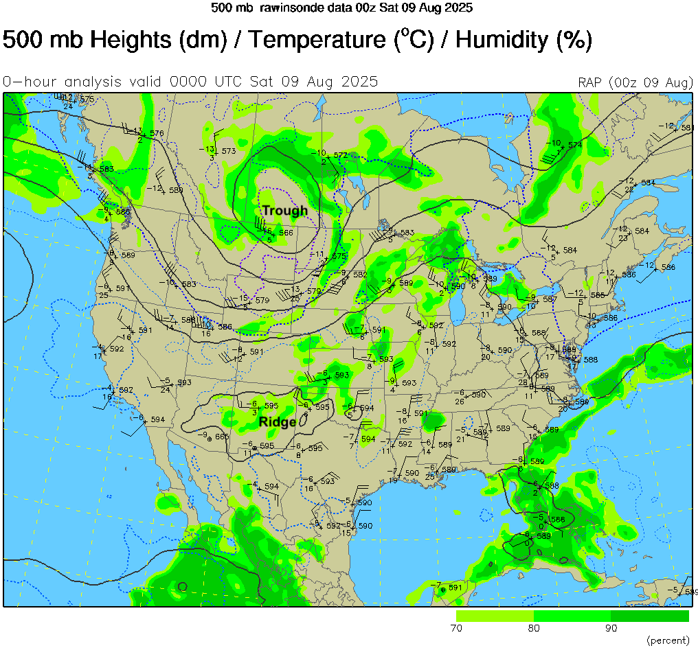
Figure 2. 500-mb height and temperature map from 00Z on August 9th
One storm that developed around McCook became particularly destructive further east once it took on more supercell characteristics once it get near Hastings. The worst damage was in Fillmore, Saline, Seward, Lancaster, and Washington counties. Winds over 90 mph were reported between Geneva and Lincoln and winds over 80 mph also occurred between Valley and Blair. A more thorough report on the event is coming soon. In the meantime, the radar loop of the event is in the related links.
The table below shows maximum temperature, minimum temperature, average temperature, the number of days with maximum temperatures ≥95°F, minimum temperatures ≥70°F, total precipitation, growing/heating/cooling degree days for all sites. Average daily potential ET for the Nebraska Mesonet stations are shown in the last column. Here are the temperature and precipitation extremes from last week:
Maximum High Temperature: 107°F, Chadron 3 SW
Minimum High Temperature: 71°F, Lincoln Airport
Minimum Low Temperature: 46°F, Agate 3 E
Maximum Low Temperature: 76°F, Falls City Brenner Field
Maximum Precipitation: 8.45", Bloomfield 3.0 S (CoCoRaHS)
Station Summary
| Station | MaxT | MinT | AvgT | >95F | >70F+ | Prcp | GDD | CDD | HDD | pET |
| ADAMS | M | M | M | M | M | 0.2 | M | M | M | N/A |
| AGATE 3 E | 96 | 46 | 72.2 | 3 | 7 | 0.05 | 157 | 52 | 0 | N/A |
| AINSWORTH | 91 | 60 | 75.3 | 0 | 7 | 0.14 | 179 | 74 | 0 | N/A |
| ALBION | 90 | 58 | 71.5 | 0 | 7 | 0.09 | 152 | 47 | 0 | N/A |
| Alda 5NW | 92 | 62 | 75.0 | 0 | 1 | 0.84 | 168 | 70 | 0 | 1.45 |
| Alliance 6NW | 98 | 52 | 73.9 | 1 | 0 | 0.00 | 153 | 62 | 0 | 2.30 |
| ALLIANCE MUNICIPAL AIRPORT ASOS | 96 | 49 | 72.9 | 1 | 4 | 0 | 92 | 32 | 0 | N/A |
| ANSELMO 2 WSW | M | M | M | M | M | 0 | M | M | M | N/A |
| ARCADIA | M | M | M | M | M | 0.06 | M | M | M | N/A |
| ARNOLD | 92 | 64 | 76.7 | 0 | 7 | 0 | 190 | 85 | 0 | N/A |
| ARTHUR | 97 | 52 | 76.1 | 1 | 7 | 0 | 185 | 80 | 0 | N/A |
| Arthur 8S | 91 | 53 | 73.5 | 0 | 0 | 0.02 | 158 | 59 | 0 | 1.75 |
| ATKINSON 3SW | M | M | M | M | M | 0 | M | M | M | N/A |
| AUBURN 5 ESE | 92 | 56 | 72.4 | 0 | 5 | 1.07 | 158 | 53 | 0 | N/A |
| AURORA MUNICIPAL AP | 84 | 62 | 72.6 | 0 | 4 | 0.57 | 92 | 32 | 0 | N/A |
| Axtell 5NE | 93 | 61 | 75.0 | 0 | 0 | 0.49 | 166 | 70 | 0 | 1.44 |
| BARTLETT 1W | M | M | M | M | M | 0 | M | M | M | N/A |
| BEATRICE 1N | M | M | M | M | M | 0.22 | M | M | M | N/A |
| BEAVER CITY | M | M | M | M | M | 0 | M | M | M | N/A |
| BELGRADE | M | M | M | M | M | 0.54 | M | M | M | N/A |
| Big Springs 6SE | 94 | 58 | 75.0 | 0 | 0 | 0.41 | 165 | 70 | 0 | 1.98 |
| Big Springs 8NE | 95 | 58 | 75.2 | 1 | 0 | 0.16 | 166 | 71 | 0 | 2.02 |
| BLOOMFIELD | M | M | M | M | M | 0 | M | M | M | N/A |
| BLUE HILL 4 SW | M | M | M | M | M | 0.13 | M | M | M | N/A |
| BRADSHAW | M | M | M | M | M | 0.51 | M | M | M | N/A |
| BRADY | 91 | 60 | 75.6 | 0 | 7 | 0.07 | 181 | 76 | 0 | N/A |
| BROADWATER 10SSE | M | M | M | M | M | 0 | M | M | M | N/A |
| Broadwater 7N | 100 | 54 | 73.8 | 1 | 0 | 0.00 | 153 | 62 | 0 | 2.20 |
| BROKEN BOW MUNICIPAL AP | 90 | 60 | 72.9 | 0 | 7 | 0.01 | 163 | 58 | 0 | N/A |
| BURWELL 2WSW | 90 | 57 | 70.4 | 0 | 7 | 0.29 | 144 | 39 | 0 | N/A |
| Bushnell 12SE | 94 | 53 | 71.6 | 0 | 0 | 0.00 | 140 | 46 | 0 | 2.53 |
| BUSHNELL 15S | 94 | 47 | 68.5 | 0 | 7 | 0 | 131 | 27 | 1 | N/A |
| CALLAWAY 8WSW | 93 | 61 | 74.8 | 0 | 7 | 0.33 | 176 | 71 | 0 | N/A |
| CAMBRIDGE | 100 | 60 | 76.4 | 1 | 7 | 0.18 | 186 | 81 | 0 | N/A |
| CANADAY STEAM PLANT | 96 | 60 | 74.6 | 1 | 7 | T | 174 | 69 | 0 | N/A |
| Central City 3W | 90 | 60 | 74.3 | 0 | 2 | 0.89 | 164 | 65 | 0 | 1.40 |
| CHADRON 3SW | 107 | 48 | 77.1 | 4 | 7 | 0.06 | 191 | 86 | 0 | N/A |
| CHADRON MUNICIPAL AP | 106 | 50 | 76.8 | 3 | 7 | 0.06 | 189 | 84 | 0 | N/A |
| CHAPPELL | M | M | M | M | M | 0 | M | M | M | N/A |
| CLAY CENTER | 95 | 52 | 73.1 | 1 | 7 | 1.26 | 164 | 60 | 1 | N/A |
| CLAY CENTER 6 ESE | M | M | M | M | M | 2.06 | M | M | M | N/A |
| COLUMBUS | 89 | 60 | 73.6 | 0 | 5 | 0.14 | 143 | 53 | 0 | N/A |
| COLUMBUS 3 NE | 91 | 61 | 74.4 | 0 | 4 | 0.26 | 148 | 58 | 0 | N/A |
| CONCORD | 87 | 60 | 72.3 | 0 | 5 | 1.24 | 135 | 45 | 0 | N/A |
| Concord 2E | 85 | 60 | 72.2 | 0 | 2 | 1.24 | 153 | 51 | 0 | 1.12 |
| Cook 4SW | 91 | 58 | 74.4 | 0 | 3 | 0.31 | 164 | 67 | 1 | 1.38 |
| CRETE 4ESE | 91 | 59 | 72.6 | 0 | 7 | 0.63 | 160 | 55 | 0 | N/A |
| CROFTON | M | M | M | M | M | 0 | M | M | M | N/A |
| CULBERTSON | 98 | 58 | 76.7 | 2 | 7 | 0.28 | 188 | 83 | 0 | N/A |
| CURTIS | 95 | 52 | 75.4 | 1 | 7 | 0.42 | 179 | 74 | 0 | N/A |
| Decatur 7S | 88 | 61 | 73.4 | 0 | 2 | 1.40 | 159 | 59 | 0 | 1.20 |
| Dickens 1NE | 92 | 57 | 74.8 | 0 | 0 | 0.04 | 165 | 69 | 0 | 1.78 |
| Eagle 3NW Beta | 92 | 60 | 74.5 | 0 | 2 | 0.87 | 165 | 67 | 0 | 1.37 |
| EDISON | 98 | 59 | 76.1 | 1 | 7 | 0.18 | 184 | 79 | 0 | N/A |
| ELGIN | 84 | 61 | 71.1 | 0 | 6 | 0.24 | 129 | 39 | 0 | N/A |
| ELSMERE 9 ENE | M | M | M | M | M | 0 | M | M | M | N/A |
| ELWOOD 8 S | M | M | M | M | M | 0.18 | M | M | M | N/A |
| EMERSON | M | M | M | M | M | 1.15 | M | M | M | N/A |
| Emmet 2E | 92 | 63 | 74.5 | 0 | 0 | 0.26 | 165 | 67 | 0 | 1.52 |
| Enders 10SW | 100 | 59 | 77.5 | 1 | 0 | 0.14 | 170 | 88 | 0 | 2.31 |
| ERICSON 8 WNW | 94 | 62 | 74.1 | 0 | 7 | 0.05 | 170 | 65 | 0 | N/A |
| EUSTIS 2 NW | 92 | 58 | 74.6 | 0 | 7 | 0.01 | 174 | 69 | 0 | N/A |
| FALLS CITY 4NE | 95 | 58 | 75.7 | 1 | 4 | 0.62 | 182 | 77 | 0 | N/A |
| FALLS CITY BRENNER FIELD | 94 | 58 | 75.4 | 0 | 4 | 0.88 | 179 | 74 | 0 | N/A |
| Firth 3N | 92 | 60 | 74.5 | 0 | 2 | 0.40 | 164 | 67 | 1 | 1.34 |
| Fordyce 4N | 86 | 61 | 73.2 | 0 | 2 | 1.59 | 159 | 58 | 0 | 1.24 |
| FREMONT | 91 | 59 | 73.3 | 0 | 5 | 1.8 | 164 | 59 | 0 | N/A |
| FRIEND 3E | 91 | 56 | 71.2 | 0 | 7 | 1.7 | 150 | 45 | 0 | N/A |
| FULLERTON 3 NW | M | M | M | M | M | 0 | M | M | M | N/A |
| GENEVA | M | M | M | M | M | 2.89 | M | M | M | N/A |
| GENOA 2S | M | M | M | M | M | 0 | M | M | M | N/A |
| GORDON 6N | M | M | M | M | M | 0 | M | M | M | N/A |
| Gothenburg 2NW | 89 | 60 | 74.7 | 0 | 0 | 0.37 | 166 | 68 | 0 | 1.54 |
| GRAND ISLAND CENTRAL NE REGIONAL AP | 94 | 62 | 75.5 | 0 | 6 | 0.39 | 180 | 75 | 0 | N/A |
| GREELEY | 92 | 58 | 72.7 | 0 | 7 | 0.22 | 161 | 56 | 0 | N/A |
| GRESHAM 3W | M | M | M | M | M | 0 | M | M | M | N/A |
| GRETNA | 90 | 59 | 71.9 | 0 | 6 | 1.13 | 155 | 51 | 1 | N/A |
| Guide Rock 3E | 99 | 62 | 78.0 | 1 | 3 | 2.30 | 178 | 91 | 0 | 1.92 |
| HARLAN COUNTY LAKE | 95 | 61 | 77.4 | 1 | 4 | 0.13 | 166 | 76 | 0 | N/A |
| HARRISBURG 12WNW | 98 | 54 | 73.4 | 2 | 7 | 0.07 | 164 | 59 | 0 | N/A |
| Harrisburg 1N | 96 | 55 | 76.0 | 1 | 2 | 0.00 | 169 | 77 | 0 | 2.64 |
| HARRISON 20 SSE | 96 | 46 | 71.2 | 1 | 7 | 0.04 | 149 | 44 | 0 | N/A |
| HARRISON 9NE | 100 | 47 | 76.4 | 2 | 4 | 0 | 107 | 47 | 0 | N/A |
| Harvard 4SW | 94 | 61 | 74.9 | 0 | 1 | 1.86 | 165 | 69 | 0 | 1.45 |
| HASTINGS 4N | 94 | 60 | 74.6 | 0 | 7 | 0.96 | 174 | 69 | 0 | N/A |
| HASTINGS MUNICIPAL AIRPORT | 95 | 61 | 76.6 | 1 | 5 | 0.18 | 188 | 83 | 0 | N/A |
| HAYES CENTER 1NW | 94 | 58 | 75.4 | 0 | 7 | 0.26 | 178 | 73 | 0 | N/A |
| Hayes Center 3N | 94 | 59 | 76.3 | 0 | 0 | 0.62 | 170 | 79 | 0 | 1.85 |
| HEBRON | 97 | 57 | 74.5 | 1 | 5 | 0.18 | 148 | 58 | 0 | N/A |
| HEBRON MUNICIPAL AP | 96 | 62 | 76.4 | 1 | 6 | 0.79 | 187 | 82 | 0 | N/A |
| HERSHEY 5 SSE | 94 | 56 | 73.7 | 0 | 7 | 0.03 | 167 | 62 | 0 | N/A |
| HOLDREGE | 94 | 59 | 74.9 | 0 | 7 | 0.2 | 176 | 71 | 0 | N/A |
| Holdrege 5N | 92 | 61 | 75.5 | 0 | 0 | 0.13 | 170 | 73 | 0 | 1.54 |
| HOLDREGE BREWSTER FIELD AP | 96 | 61 | 76.4 | 1 | 7 | 0.1 | 185 | 80 | 0 | N/A |
| HOWELLS | 90 | 59 | 74.6 | 0 | 5 | 0.86 | 174 | 69 | 0 | N/A |
| HUBBELL | M | M | M | M | M | 0.5 | M | M | M | N/A |
| IMPERIAL | 100 | 59 | 76 | 1 | 7 | 0.05 | 184 | 79 | 0 | N/A |
| IMPERIAL MUNICIPAL AP | 99 | 57 | 76.4 | 1 | 7 | 0.1 | 187 | 82 | 0 | N/A |
| Indianola 8SW | 98 | 59 | 77.2 | 1 | 0 | 0.68 | 173 | 85 | 0 | 2.04 |
| Kearney 3E | 92 | 62 | 75.3 | 0 | 1 | 0.43 | 172 | 72 | 0 | 1.54 |
| KEARNEY 4 NE | 95 | 60 | 74.5 | 1 | 7 | 0.03 | 173 | 68 | 0 | N/A |
| KEARNEY MUNICIPAL AP | 92 | 62 | 75.4 | 0 | 7 | 0.37 | 179 | 74 | 0 | N/A |
| Keystone 4W | 91 | 59 | 74.4 | 0 | 0 | 0.05 | 164 | 66 | 0 | 1.88 |
| KILGORE 1NE | M | M | M | M | M | 0 | M | M | M | N/A |
| KINGSLEY DAM | 94 | 58 | 74.3 | 0 | 7 | 0.07 | 171 | 66 | 0 | N/A |
| Leigh 1W | 88 | 59 | 73.2 | 0 | 2 | 1.03 | 157 | 57 | 0 | 1.23 |
| Lexington 4S | 92 | 62 | 75.1 | 0 | 0 | 0.18 | 170 | 71 | 0 | 1.43 |
| LEXINGTON JIM KELLY FIELD | 94 | 62 | 76.9 | 0 | 6 | 0.07 | 190 | 85 | 0 | N/A |
| LINCOLN 11 SW | 93 | 59 | 75.1 | 0 | 5 | 0.25 | 178 | 73 | 0 | N/A |
| Lincoln 1500 N 45th | 95 | 61 | 76.0 | 1 | 3 | 1.13 | 174 | 77 | 0 | 1.40 |
| LINCOLN 8 ENE | 92 | 59 | 74.8 | 0 | 6 | 1.51 | 175 | 70 | 0 | N/A |
| LINCOLN AIRPORT | 94 | 59 | 75.7 | 0 | 5 | 0.84 | 182 | 77 | 0 | N/A |
| LISCO | M | M | M | M | M | 0 | M | M | M | N/A |
| LODGEPOLE 8N | 100 | 53 | 72.1 | 1 | 7 | M | 156 | 51 | 0 | N/A |
| Long Pine 20S | 87 | 61 | 73.1 | 0 | 0 | 0.04 | 159 | 57 | 0 | 1.62 |
| LORETTO 7W | M | M | M | M | M | 0 | M | M | M | N/A |
| LOUP CITY | 94 | 59 | 73.5 | 0 | 7 | 0.91 | 167 | 62 | 0 | N/A |
| MAX 13N | M | M | M | M | M | 0 | M | M | M | N/A |
| MC COOK #2 | M | M | M | M | M | M | M | M | M | N/A |
| MCCOOK MUNICIPAL AP | 102 | 56 | 78.4 | 2 | 7 | 0.18 | 200 | 95 | 0 | N/A |
| MEAD 6S | 91 | 56 | 71.4 | 0 | 7 | 1.67 | 151 | 46 | 0 | N/A |
| Memphis 4N | 90 | 59 | 73.7 | 0 | 1 | 1.36 | 160 | 61 | 0 | 1.24 |
| Memphis 5N | 90 | 60 | 73.7 | 0 | 2 | 1.47 | 161 | 61 | 0 | 1.24 |
| Merna 2SW | 89 | 61 | 72.9 | 0 | 0 | 0.00 | 155 | 55 | 0 | 1.18 |
| MILLER | M | M | M | M | M | 0.09 | M | M | M | N/A |
| MINATARE DAM (USBR) | M | M | M | M | M | 0 | M | M | M | N/A |
| MINDEN | 95 | 59 | 73.3 | 1 | 7 | 0.97 | 165 | 60 | 0 | N/A |
| MULLEN 22N | M | M | M | M | M | 0.32 | M | M | M | N/A |
| Naper 12SW | 90 | 62 | 75.2 | 0 | 0 | 0.00 | 169 | 71 | 0 | 1.74 |
| NAPONEE | M | M | M | M | M | 0.55 | M | M | M | N/A |
| NEBRASKA CITY 2 | M | M | M | M | M | 0.34 | M | M | M | N/A |
| NEBRASKA CITY 2NW | 92 | 59 | 75 | 0 | 4 | 0.52 | 177 | 72 | 0 | N/A |
| Nebraska City 3W | 91 | 59 | 74.9 | 0 | 4 | 0.01 | 168 | 70 | 1 | 1.25 |
| NEWCASTLE | M | M | M | M | M | 0.05 | M | M | M | N/A |
| NORFOLK KARL STEFAN MEMORIAL AP | 89 | 60 | 74 | 0 | 5 | 0.66 | 169 | 64 | 0 | N/A |
| NORTH LOUP | 93 | 59 | 73.4 | 0 | 7 | 0.52 | 165 | 60 | 0 | N/A |
| NORTH PLATTE 3ENE | 91 | 61 | 74.5 | 0 | 2 | 0.05 | 49 | 19 | 0 | N/A |
| North Platte 3SW Beta | 92 | 58 | 75.0 | 0 | 0 | 0.01 | 165 | 70 | 0 | 1.50 |
| NORTH PLATTE EXP FARM | M | M | M | M | M | 0 | M | M | M | N/A |
| NORTH PLATTE REGIONAL AP | 92 | 57 | 74.4 | 0 | 7 | 0.07 | 172 | 67 | 0 | N/A |
| O'NEILL | 89 | 58 | 72.9 | 0 | 6 | 0.16 | 139 | 49 | 0 | N/A |
| Oakland 4W | 88 | 60 | 72.8 | 0 | 1 | 0.67 | 155 | 54 | 0 | 1.10 |
| OGALLALA | 96 | 58 | 73.9 | 1 | 7 | 0.04 | 169 | 64 | 0 | N/A |
| OMAHA EPPLEY AIRFIELD | 93 | 61 | 75.6 | 0 | 4 | 1.62 | 180 | 75 | 0 | N/A |
| ORCHARD 9NNE | M | M | M | M | M | 0.94 | M | M | M | N/A |
| Ord 2N | 93 | 60 | 73.9 | 0 | 0 | 0.10 | 161 | 62 | 0 | 1.40 |
| ORD EVELYN SHARP FIELD | 94 | 58 | 74.1 | 0 | 7 | 0.1 | 170 | 65 | 0 | N/A |
| ORD NO 2 | M | M | M | M | M | 0.25 | M | M | M | N/A |
| ORLEANS 2 W | M | M | M | M | M | 0.18 | M | M | M | N/A |
| OSCEOLA | 92 | 58 | 74.2 | 0 | 6 | 0.22 | 172 | 67 | 0 | N/A |
| OSHKOSH | M | M | M | M | M | 0 | M | M | M | N/A |
| OSHKOSH 10 NE | M | M | M | M | M | 0 | M | M | M | N/A |
| Oshkosh 6N | 98 | 57 | 75.0 | 1 | 0 | 0.02 | 163 | 70 | 0 | 2.31 |
| Overton 6SE | 94 | 60 | 74.6 | 0 | 0 | 0.10 | 165 | 67 | 0 | 1.40 |
| OXFORD 6NNW | 100 | 60 | 76.1 | 1 | 7 | 0.25 | 186 | 81 | 0 | N/A |
| PIERCE | M | M | M | M | M | 2.45 | M | M | M | N/A |
| Pierce 2SW | 87 | 60 | 72.8 | 0 | 2 | 2.58 | 156 | 55 | 0 | 1.30 |
| PLAINSVIEW RANCH | M | M | M | M | M | 0 | M | M | M | N/A |
| Plattsmouth 2SE | 90 | 60 | 73.7 | 0 | 3 | 1.57 | 160 | 61 | 0 | 1.22 |
| POLK | M | M | M | M | M | 0.24 | M | M | M | N/A |
| RAVENNA | 92 | 60 | 73.5 | 0 | 7 | 0.06 | 166 | 61 | 0 | N/A |
| ROYAL 2SE | M | M | M | M | M | 0 | M | M | M | N/A |
| Rulo 5SW | 92 | 59 | 75.2 | 0 | 3 | 0.72 | 169 | 71 | 0 | 1.42 |
| SAINT PAUL | M | M | M | M | M | 0.19 | M | M | M | N/A |
| SALEM 5SW | M | M | M | M | M | 0.79 | M | M | M | N/A |
| SCOTTSBLUFF 1E | 99 | 55 | 75.4 | 2 | 7 | 0.02 | 180 | 75 | 0 | N/A |
| Scottsbluff 2NW | 99 | 54 | 75.1 | 1 | 0 | 0.00 | 157 | 71 | 0 | 2.17 |
| Scottsbluff 6NW | 96 | 56 | 74.1 | 1 | 0 | 0.00 | 155 | 64 | 0 | 2.05 |
| SCOTTSBLUFF W B HEILIG FIELD AP | 101 | 53 | 75.5 | 1 | 7 | T | 180 | 75 | 0 | N/A |
| SEWARD | 89 | 55 | 72.9 | 0 | 7 | 1.14 | 162 | 57 | 0 | N/A |
| SHELBY 3NE | M | M | M | M | M | 0.6 | M | M | M | N/A |
| Shelton 2SW | 92 | 61 | 74.4 | 0 | 0 | 0.05 | 165 | 66 | 0 | 1.33 |
| SHICKLEY 4S | M | M | M | M | M | 0.45 | M | M | M | N/A |
| SHUBERT 2SW | M | M | M | M | M | 1.04 | M | M | M | N/A |
| Sidney 2NW | 101 | 56 | 74.2 | 1 | 0 | 0.25 | 154 | 64 | 0 | 2.33 |
| SIDNEY MUNICIPAL AP | 101 | 52 | 73.6 | 1 | 7 | 0.26 | 168 | 63 | 0 | N/A |
| Smithfield 2E | 92 | 61 | 75.3 | 0 | 0 | 0.16 | 170 | 72 | 0 | 1.50 |
| SPRINGVIEW 2NW | 95 | 57 | 75 | 1 | 7 | T | 177 | 72 | 0 | N/A |
| STANTON 7NE | 74 | 57 | 65.5 | 0 | 1 | 0.45 | 16 | 1 | 0 | N/A |
| STAPLETON 5W | 89 | 58 | 73 | 0 | 7 | 0.05 | 163 | 58 | 0 | N/A |
| SUPERIOR | 98 | 60 | 76.8 | 1 | 5 | 0.2 | 188 | 83 | 0 | N/A |
| TABLE ROCK 4N | 93 | 58 | 72.3 | 0 | 6 | 0.25 | 157 | 53 | 1 | N/A |
| TECUMSEH 1S | M | M | M | M | M | 0 | M | M | M | N/A |
| TEKAMAH MUNICIPAL AP | 90 | 59 | 73.6 | 0 | 6 | 2.35 | 166 | 61 | 0 | N/A |
| TRENTON DAM 1N | 99 | 55 | 77.1 | 2 | 7 | 0.51 | 191 | 86 | 0 | N/A |
| VALENTINE MILLER FIELD AP | 94 | 57 | 75.5 | 0 | 7 | 0.03 | 180 | 75 | 0 | N/A |
| VALENTINE NO. 1 | 92 | 55 | 73.7 | 0 | 7 | 0.04 | 167 | 62 | 0 | N/A |
| VALENTINE NWR | 91 | 57 | 75.5 | 0 | 7 | 0 | 180 | 75 | 0 | N/A |
| VALLEY NWS | 90 | 62 | 74.9 | 0 | 5 | 4.13 | 176 | 71 | 0 | N/A |
| Valparaiso 6NW | 89 | 61 | 74.3 | 0 | 4 | 0.33 | 164 | 65 | 0 | 1.19 |
| VERDEL 6SSE | 92 | 60 | 75.1 | 0 | 6 | 0.69 | 178 | 73 | 0 | N/A |
| WAKEFIELD 3NW | 89 | 56 | 72.4 | 0 | 6 | 0.84 | 159 | 54 | 0 | N/A |
| WALLACE 2W | 92 | 56 | 72.9 | 0 | 7 | 0.02 | 162 | 57 | 0 | N/A |
| Walton 5NW | 93 | 61 | 75.4 | 0 | 3 | 1.11 | 169 | 73 | 0 | 1.47 |
| WEST POINT | 90 | 62 | 72.9 | 0 | 5 | 1.08 | 162 | 57 | 0 | N/A |
| WHITMAN 5 ENE | 97 | 55 | 73.9 | 1 | 7 | 0.08 | 169 | 64 | 0 | N/A |
| Whitman 5NE | 95 | 50 | 72.8 | 0 | 0 | 0.14 | 152 | 55 | 0 | 1.88 |
| WILSONVILLE | M | M | M | M | M | 0.13 | M | M | M | N/A |
| Winslow 6E | 89 | 61 | 73.6 | 0 | 3 | 1.36 | 161 | 60 | 0 | 2.18 |
| Wood River 5SE | 92 | 61 | 74.8 | 0 | 1 | 0.48 | 167 | 68 | 0 | 1.42 |
| YORK | 93 | 61 | 75.2 | 0 | 5 | 0.64 | 178 | 73 | 0 | N/A |
| York 2W | 92 | 62 | 75.3 | 0 | 2 | 0.29 | 172 | 72 | 0 | 1.28 |
| YORK 3N | 93 | 58 | 73 | 0 | 6 | 0.67 | 163 | 58 | 0 | N/A |


