
Hello NSCO community! This past week, Nebraska started the week with higher temperatures, which ran mostly in the 50s with a few 60s popping up in central to southeast Nebraska, thanks to a broad ridge that was situated over much of the country. A quick-hitting cold front slid through late Monday night into Tuesday, knocking temperatures down a bit, but even then we stayed well above late-December normals. Midweek, by Christmas Eve/Christmas Day the bigger story turned into moisture trapped near the surface with dewpoints climbing into the 40s to near 50 in parts of eastern Nebraska, setting the stage for widespread fog and low clouds that kept humidity high and slowed daytime warming, especially eastern Nebraska. Most of the week stayed dry, but the quiet weather stretch ended late Saturday into Sunday when a stronger system finally brought precip back into the region.
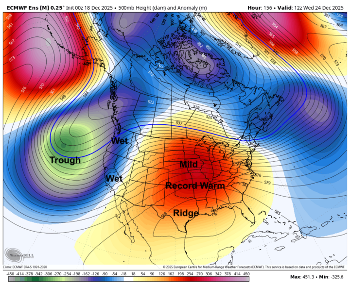
Looking at the larger scale of our atmosphere, the warm ridging pattern was very persistent with upper-level heights staying tight enough to keep Nebraska in that mild air mass for most of the week. Out west/central Nebraska, 850 mb temps surged into the mid 50s F midweek, and even low 60s, which was near-record warmth temperatures for December. Late week, subtle shortwaves and cloud/fog issues became an issue regarding road hazards (especially in the east), and by the weekend, the pattern finally broke as a cold trough made its way through the area. I will be using a graphic made by Eric Hunt to demonstrate the outlook from this past week. As you can see below, we had a massive ridging pattern that brought extremely warm temperatures for the state of Nebraska, and the Midwest in general.
We had a weak cold front Monday night into Tuesday, which brought more of a wind shift and modest cool-down than a true winter punch. We also had many fog issues due to the light winds, and higher low-level moisture which helped fog redevelop most of the state Christmas Eve night into Christmas morning, and dense fog became a real travel issue in eastern Nebraska (and nearby). The big front arrived Saturday night into Sunday with a strong cold front rapidly increasing northwest winds, precipitation changing phase (rain, and snow in spots), and deteriorating travel conditions as temperatures dropped behind the cold front.
For most of the week, Nebraska experienced dry air and the ridging pattern in the early to midweek part of this past week kept precipitation off the map. The exception arrived late Saturday into Sunday with rain developing ahead of the front mainly in the south/east, while colder air behind the boundary supported rain changing to snow farther north, with gusty winds raising concerns for visibility reductions and slick spots. Snow totals were generally light, but enough to matter with the wind northeast Nebraska, which had potential for a dusting to a couple inches, and blowing snow lingered as snow tapered Sunday.
Warmth/records: Several climate sites had breaking daily record highs during the midweek peak (especially Christmas Eve into Friday), with forecast highs well into the upper 60s to around 70 in parts of western/central Nebraska.
Cold snap: After the weekend front, temps fell back to reality fast with highs dropping into the teens/20s in some areas and wind chills went sub-zero, especially overnight into Monday of last week.
Nebraska went from late-December spring temperatures early and midweek, to foggy/low-cloud humidity and travel impacts around Christmas, and then finished with a sharp, windy, wintry reset late Saturday into Sunday. Looking ahead, this week, we will be experiencing colder air, which will linger into Monday night tonight, then a rebound begins Tuesday/Wednesday back into the 30s/40s (and eventually milder again), with overall dry conditions returning.


