Hello NSCO community, and happy Monday! This past week, we started experiencing a warmer weather transition for the state. Nebraska featured a change from near-seasonal winter conditions to noticeable warmer temperatures later into the week compared to late January. Precipitation early in the week was light and scattered, while late-week conditions turned predominantly dry statewide as upper-level ridging took control. I will be going into more detail below!
This past week began with weak shortwave troughs within northwesterly flow aloft impacting the central Plains. At 500 mb, these disturbances provided enough lift to convect some scattered light snow and occasional freezing drizzle across parts of Nebraska. At 850 mb, temperatures early in the week supported a small thermal profile, with values near or slightly below 0°C over eastern Nebraska, explaining the mixed precipitation types observed. By mid to late week, strong upper-level ridging expanded eastward from the west of Nebraska. This ridge promoted subsidence, warming temperatures at both 850 mb and the surface, which impacted precipitation amounts, decreasing the chances of heavier precipitation. The strengthening ridge and downslope flow off the Rockies allowed for warmer temperatures, especially across western and southwest Nebraska.
A few weak surface fronts moved through the state early in the week, including a weak cold front that produced light wintry precipitation near and north of Interstate 80. These frontal boundaries had few impacts on driving conditions. Surface winds also shifted westerly to northwesterly, enhancing downslope warming. Later in the week, a dry cold front passed through colder temperatures, and breezy conditions at times. Fog and low stratus were occasionally observed during the overnight and morning hours, especially across north-central Nebraska.
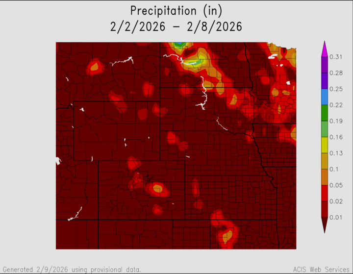
Precipitation totals for the week remained light across Nebraska. Early-week snowfall generally ranged from a trace to a few tenths of an inch, with localized areas in northeast Nebraska briefly approaching around one-half inch under some convective snow showers. Light freezing drizzle occurred, but ice accumulations remained minimal. Much of western and southwest Nebraska saw little to no measurable precipitation. Late in the week, dry conditions dominated statewide as temperatures climbed well above normal. While precipitation was limited, the combination of warm temperatures and remaining snow and ice cover increased concerns for river ice breakup, particularly along the Platte, Elkhorn, and Loup Rivers.
Temperature and precipitation extremes this week highlighted the sharp warming trend across the state. The coldest daytime highs occurred early in the week across northeast Nebraska, while the warmest conditions were observed late in the week across western and southwest Nebraska, where highs reached well into the 50s and low 60s. Overnight lows early in the period dipped into the low to mid-20s across much of the state, before moderating later in the week. Precipitation extremes were modest, with the highest totals associated with early-week light snow and mixed precipitation events, and many locations recording little to no measurable precipitation overall.
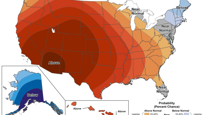
In summary, Nebraska experienced a week defined by a shift from weak winter disturbances to a dominant ridge-driven warm pattern. Early-week light wintry precipitation gave way to dry, unseasonably mild conditions by Thursday and beyond. Nebraska Mesonet and cooperative observing sites clearly reflected this transition, showing steady increases in temperature and a sharp decline in precipitation frequency as the ridge built overhead. A time-series plot of Mesonet stations would illustrate near-uniform warming across the state, with the strongest anomalies in western Nebraska. These conditions set the stage for continued warmth into the following week, along with hydrologic concerns tied to river ice movement.