
Hello NSCO community! This week across Nebraska we were dominated by an unusually warm air mass for early February, with temperatures running well above seasonal averages statewide. Many locations across central, eastern, and western Nebraska reached the upper 60s to mid-70s early in the week, with record highs observed at sites such as Lincoln, Omaha, Grand Island, and Hastings. These warm temperatures were accompanied by very dry air, particularly across western and north-central Nebraska, where afternoon relative humidity values dropped into the teens and low 20s. Humidity remained slightly higher across eastern Nebraska along with those higher temperatures. Precipitation was very little the first half of the week, as upper-level ridging and a generally zonal flow pattern limited moisture return across the region.
Looking at the various height levels, and their tendency over the week, we had 850 mb, warm air advection was evident ahead of a weak upper-level ridge, supporting surface temperatures far above normal, especially on Monday. 850-mb temperatures remained very warm even after the passage of a weak cold front, helping daytime highs stay in the 40s and 50s through midweek. At 500 mb, the flow was largely zonal with embedded shortwave disturbances passing north of the state, keeping Nebraska in a relatively quiet weather regime. The lack of a deep trough overhead limited large-scale ascent, which explains the minimal precipitation and mostly dry conditions observed statewide.
A dry cold front moved southward through Nebraska late Monday into early Tuesday, marking the end of the record-setting warmth. Behind the front, winds shifted to the north and northwest, with gusts exceeding 30 mph in parts of north-central and western Nebraska. Despite the frontal passage, temperatures remained above normal for mid-February. One notable impact of the prolonged warmth was ongoing ice movement along the Platte, Loup, and Elkhorn Rivers, prompting Flood Watches and continued monitoring for ice jam flooding, especially near Grand Island and downstream locations.
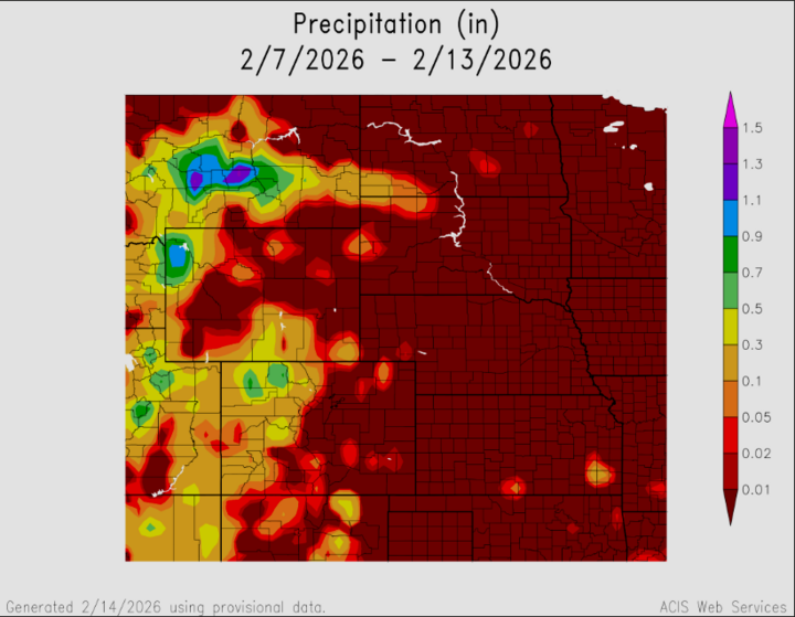
Precipitation through the week was sparse, with most of Nebraska remaining dry. Low-probability chances for light rain were introduced mid-week, mainly across northern and eastern portions of the state, but amounts remained minimal. Any precipitation that did occur was light, primarily rain during the daytime, with a rain-snow mix possible overnight as temperatures dipped closer to freezing. Overall, the lack of meaningful precipitation continued to support dry conditions and elevated fire weather concerns earlier in the week.
- Maximum High Temperature: Mid to upper 70s, central and south-central Nebraska
- Minimum High Temperature: Upper 40s to near 50°F, northern Nebraska
- Minimum Low Temperature: Low to mid-20s, central Nebraska
- Maximum Low Temperature: Upper 30s, eastern Nebraska
- Maximum Precipitation: Trace to a few hundredths of an inch, mainly northern Nebraska
Nebraska experienced an exceptionally warm and dry February week driven by persistent ridging and zonal flow aloft, with only brief cooling following a dry cold frontal passage. Fire weather and ice jam flooding were the primary concerns, while precipitation remained limited and light, reinforcing the overall dry and warm pattern observed this week.


