
Hello NSCO community! We are officially halfway through the week, and what an eventful week it has been. Nebraska started this past week unusually mild and pretty dry. Monday and Tuesday (Jan 12–13), and warmed into the mid-50s to around 60°F, especially west of the Missouri River, with low-50s more common to the east. This alone would be something seen in mid to late October, maybe early November, so seeing these temperatures in January is very unusual. We had low-level air stay dry enough so that most places only saw partly cloudy to overcast conditions with little to no rainfall recorded for most of the state. By Wednesday (Jan 14), cooler air had filtered in and highs fell back to the low–mid 30s with a brisk north wind. Thursday (Jan 15) brought a quick warm-up (many spots 40s to low 50s). Heading into Friday, we had stronger winds, and scattered snow showers in the north/east portion of the state. Over the weekend (Jan 17–18), we experienced highs between 20–30°F with bitter wind chills with the majority of the events laid out below in more detail.
Early-week warmth came from upper-level ridging and warm air advection near 850 mb, with slight westerly flow helping boost surface temperatures into the 50s and 60s. As the week progressed, a stronger system impacted most of the state, especially in the eastern half of Nebraska. By late Thursday into Friday, a 50–60 kt low-level jet on the backside of the 850-mb low, supporting widespread strong northwest gusts mentioned above, which impacted central and eastern Nebraska from the 16th-18th which created an increased risk for fire danger in the area.
Tuesday’s weak shortwave that impacted Nebraska tried to trend some light precipitation, but dry air close to the surface limited most places to nothing more than a few sprinkles in the southeast-central part of the state. But like I mentioned above, the bigger situation was wind. The tightening pressure gradient and deep mixing brought 20–25 mph northwest winds with gusts up to ~40 mph in parts of northeast Nebraska Tuesday, then again a much stronger push late Thursday into Friday with widespread 40+ mph gusts reported
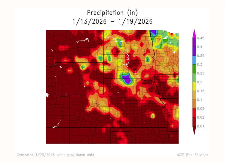
For most of Nebraska, this week was overall dry, with little to note for precipitation in any part of the state. Using the ACIS graphs, you can see this trend especially. However, the more meaningful precipitation window arrived late Thursday into Friday, with higher totals north of I-80 and especially far northeast Nebraska were seen. This is because of thick, and heavy snowfall that was experienced in the area.
To wrap things up, we had an interesting week with high winds, and colder and windier with scattered snow showers late week, followed by a cold weekend and gradual improvement after. Looking ahead, the longer-range forecast calls for a cool start to this week (20s/30s) and freezing temperatures in the eastern part of the state later in the week. Make sure to bundle up and stay warm everyone, and thank you for reading into Nebraska's weekly weather phenomena!


