
Hello NSCO community, and happy February! As you all may have heard, Punxsutawney Phil, the famous groundhog that determines whether we get an early spring, or six more weeks of winter, unfortunately went with the latter option due to a cloudy morning over in Pennsylvania. So, if we experience a snowstorm out in April, it's not on any meteorologists!
This week, we will be covering our last week of January and what was experienced here in Nebraska. This week across Nebraska featured a continuation in cold temperatures from an influx of Arctic air and multiple rounds of light snow across parts of the state. Early in the week, highs climbed into the upper 20s and low 30s across eastern Nebraska, while western areas, especially toward the Panhandle and southwest, experienced slightly warmer temperatures downslope of the flow, reaching up to the 40s to near 50°F in some western locations. Later in the week, colder air surged back in, dropping highs into the 10s and 20s and sending overnight lows below zero in north, central, and eastern Nebraska.
As the week progressed, Nebraska sat under a predominantly northwest flow aloft, downstream of a ridging pattern over the western United States and of periodic troughing over the central and eastern parts of the country. At 500 mb, shortwave disturbances were repeatedly noted. At 850 mb, weak warm-air advection ahead of these waves briefly supported warmer surface temperatures, especially midweek and again heading into the brief weekend warmup before cold advection followed behind the frontal passages. Periods of mid-level frontogenesis were noted, especially Thursday into Friday, supporting narrow bands of light snow for parts of the state. The lack of deep, sustained moisture kept snowfall amounts light but kept snow accumulation to a minimum.
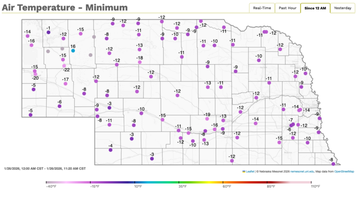
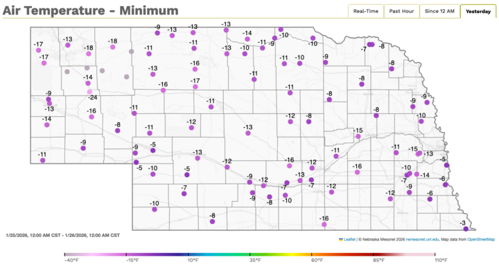
I would again like to cite and thank the extension educator and faculty member Eric Hunt for providing the images below from our Mesonet website.Both images are station‐plot maps of minimum temperatures (°F) across Nebraska, with each dot representing a Mesonet site. The numbers next to the dots are the lowest recorded air temperatures during the selected period. Purple shading corresponds to very cold values on the color scale at the bottom, which were experienced in the last 24 hours from 12pm last Monday on the 26th. The map shows that nearly the entire state is below 0°F, with most readings: –8°F to –17°F, which is extremely cold.
A series of weak surface lows and frontal boundaries came early to mid-week. A cold front that moved through the area brought sub-zero lows to most of the state. Later, a warm front brought in some light snow as it lifted through the region. Some areas also experienced brief transitions of mixed precipitation near the end of snow events during the week as warmer air intruded aloft, but the impacts remained minimal. Winds were generally light to moderate, though gustier southerly flow developed ahead of some systems, contributing to blowing snow concerns in localized areas, especially near Valentine, Nebraska.
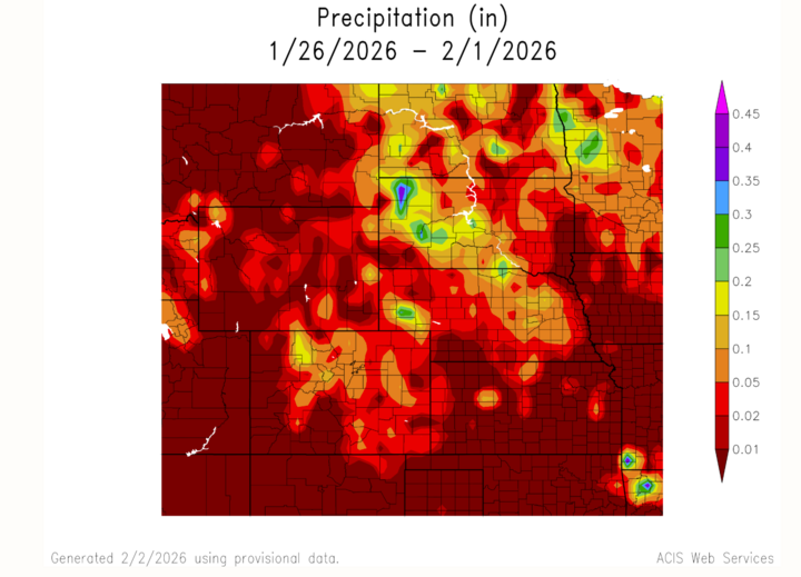
Precipitation totals were very light statewide. Many locations saw a few tenths of an inch up to around 1 inch of snow from isolated events. Southern and southwestern parts of the state often saw less, with some events producing only flurries or brief light snow. Despite the low totals, slick travel was possible at times due to cold surface temperatures and repeated light accumulations, especially over western Nebraska near I-80. Overall, this northwest-flow winter pattern created frequent but minor snow events for the state.
Temperature and Precipitation Extremes For Nebraska
Warmest conditions: Western and southwest Nebraska during downslope/warm advection periods, with highs pushing into the 40s and locally higher into the middle of the week.
Coldest conditions: Late week into the weekend, with subzero lows in north-central and eastern Nebraska and wind chills dropping well below zero.
Greatest snowfall potential: Northeast Nebraska, where banded snow produced up to one inch in some areas
Lightest precipitation: Farther south and southwest, where some systems produced only flurries or minimal accumulation.
In summary, Nebraska experienced a variable week for winter precipitation, and temperatures, marked by short-lived warmups, multiple weak light snow-producing systems, and a notable late-week Arctic push. Looking ahead to this week, the overall trend beyond this pattern points toward moderation as ridging builds east, but the week itself was a good example of how even modest disturbances can keep winter weather active. Have a wonderful week!


