
Hello, NSCO community! The state of Nebraska spent the first half of the week in a remarkably mild pattern for early January. For instance, eastern Nebraska started out with areas of dense fog early Tuesday which were associated with lower temperatures. That cleared west-to-east in the early afternoon, which warmed the atmosphere, and helped temperatures jump into the upper 40s to upper 50s Tuesday and 50s to low 60s Wednesday. Those warm afternoons came with very dry air (afternoon relative humidity at about 25–35% in eastern NE) which unfortunately bumped up fire danger concerns. Out west, highs commonly were in the 50s to near 60 Tuesday, then upper 50s to 60 again Wednesday, paired with very low humidity (teens to low 20s) and breezy west winds across the Sandhills and southwest. By late week, the ridge loosened its grip and a series of troughs/shortwaves began to nudge the state back toward more seasonable conditions.
The warmth midweek was supported by a strong warm-advection setup and unusually warm air aloft western Nebraska even had 850 mb temperatures above the 90th percentile climatology for Wednesday, which is a big reason surface highs were able to push the 50s and 60s. A shortwave trough moved out of the southern High Plains Thursday and another mid-level trough with closed circulation influenced the weather Friday into Saturday.
The main situation early last week was that fog/low stratus in the east that eroded quickly Tuesday morning. After that, it was more about wind shifts and pressure-gradient changes as the late-week system came into play, giving a precipitation setup with colder air filtering in behind the low, especially in southeast Nebraska. As the system moved through Thursday evening, colder air arriving from the north helped flip rain to a rain/snow mix and then light snow in parts of eastern Nebraska.
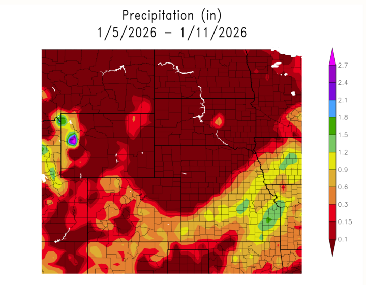
Precipitation chances ramped up Thursday into early Saturday, with the greatest totals focused in southeast Nebraska. In the Omaha area, rain overspread the region Thursday, supporting heavier showers across southeast NE, and storm-total liquid peaking around 0.75–1.00 inch in that corridor before tapering off northwestward. As colder air worked in, rain transitioned to light snow, with trace to ~1 inch most likely along/north of I-80 late Thursday night. West/central Nebraska saw more limited impacts overall.
This week’s “extremes” were all about the midweek warmth and the late-week wet corridor in the southeast:
Warmest daytime highs: typically upper 50s to low 60s (most favored south of I-80 and parts of central/western NE) during Tue–Wed.
Coldest mornings: after the system, lows dropped into the 20s in the east late Thu night with freezing concerns on wet surfaces.
Wettest zone: southeast Nebraska where storm totals peaked near 0.75–1.00" liquid.
Snow potential: generally trace to around 1 inch in parts of eastern Nebraska with the late Thu changeover.
Overall, Nebraska rode a midweek ridge into near-record-feeling warmth for January, paired with very low humidity and elevated fire weather concerns, then shifted into a late-week trough-driven event bringing rain, a brief rain-to-snow transition, and the highest precipitation totals in the southeast. Looking ahead, the broader forecast discussion points toward a rebound to 40s and 50s early this week (after the weekend cool-down), with another trough possibly bringing the next precip chance around late Tuesday into Wednesday.


