
Hello NSCO community! We have had a major week of weather and wildfire impacts across the state, which I will cover below for our weekly discussion. This past week, across Nebraska, a dangerous and historic fire weather pattern was experienced, driven by extreme heat, very low humidity, and strong winds. Temperatures surged well above normal, with highs in the 90s across much of the state, an exceptionally unusual occurrence for mid-March. At the same time, relative humidity dropped into the single digits, meaning the air was extremely dry, and vegetation became highly flammable. These conditions, combined with ongoing drought, created critical fire levels, which is where an environment in which fires can ignite easily and spread rapidly.
That setup led directly to multiple large wildfires across Nebraska, including the Morrill Fire and Cottonwood Fire, which together burned hundreds of thousands of acres and forced evacuations in several counties. Some fires became among the largest in state history, fueled by strong winds and dry grasses. While firefighters have made progress, reports indicate that the fires are only partially contained, and crews continue working under difficult conditions with ongoing weather concerns.
We can see how large-scale weather patterns can drive fire outbreaks. In this case, a strong ridge of high pressure over the western U.S. acted like a cap, keeping warm, dry air low to the surface and allowing temperatures to soar, suppressing cloud formation and precipitation. At the same time, sinking air under the ridge dried out the atmosphere, while deep boundary-layer mixing pulled even drier air from aloft down to the surface. This combination caused relative humidity to plummet, one of the most critical ingredients for wildfire development. According to fire weather guidance from the National Weather Service, these low humidity values, paired with strong winds, have met the criteria for Red Flag conditions, signaling extreme fire danger.
A major change arrived late Saturday into Sunday, when a strong cold front pushed through Nebraska. Behind it, winds shifted to the north and increased dramatically, with gusts reaching 35 to 50 mph. While temperatures dropped significantly, these strong winds made the wildfire situation more dangerous in the short term. Wind is one of the most important drivers of fire behavior, as it can push flames rapidly across grasslands, carry embers long distances, and make fires much harder to contain. This is why officials continued issuing fire weather warnings even after the temperatures dropped.
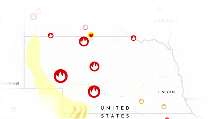
Beyond the flames themselves, wildfire impacts extended across the state. The figure above shows the areas most affected, including the southwest of North Platte (near the Cottonwood Fire, which has burned 128,289 acres so far) and up through Alliance in the west (the Morrill Fire, which has burned 642,029 acres so far). The yellow areas indicate heavy smoke in the region. Wildfire smoke can travel long distances and affect air quality in both rural and urban areas, posing health risks even far from the fires, which makes this situation very dangerous. In addition, these fires have had major impacts on agriculture, especially grazing lands, and have strained local emergency resources. The situation highlights how fire weather is not just a meteorological issue; it’s also a public safety and environmental concern.
Rainfall this week was very little for the state, and any chances for precipitation were slight and scattered, far too little to improve conditions. This is shown below in the ACIS precipitation map. This lack of moisture has allowed drought conditions to worsen and has kept fuels extremely dry. Even though some fires are becoming more contained, the overall pattern remains concerning, with continued dry conditions and another warming trend expected in the coming days.

This past week serves as a clear reminder of how quickly wildfire risk can develop on the Great Plains. When heat, low humidity, wind, and drought all align, Nebraska can experience fast-moving and dangerous wildfires, even outside of the traditional fire season. With conditions expected to remain dry and periodically windy, fire danger will likely stay elevated. Residents are strongly encouraged to follow burn bans, avoid activities that could spark fires, and stay aware of rapidly changing conditions.


