
Hello NSCO community, and happy Tuesday! This week across Nebraska began on a cooler and relatively quiet side, with widespread highs in the mid-50s under mostly cloudy skies on Monday last week. A weak shortwave moving through the region introduced some mid-level lift, and with persistent dry air being close to the surface, there was little chance for any impactful precipitation to occur, resulting in only isolated sprinkles across parts of central and eastern Nebraska. Humidity values remained low, especially across western Nebraska where dewpoints dropped into the teens and 20s, contributing to the ever-present elevated fire weather concerns. By Tuesday, a strong warming trend took hold as southerly flow returned, pushing highs into the upper 60s and 70s statewide under mostly dry conditions.
At the synoptic scale, the pattern was dominated early by a surface high pressure system centered over the northern Plains, which quickly shifted east and allowed for return flow to establish itself across Nebraska. Aloft, weak shortwave energy traversed the region Monday, followed by increasing ridging from the southwestern United States into the central Plains by Tuesday. This ridge amplified further into Wednesday, with 850 mb temperatures rising and contributing to widespread above-normal surface temperatures. By midweek, strong thickness advection and a tightening baroclinic zone supported highs soaring into the 80s and even low 90s in southern Nebraska.
Surface features played a major role in the evolving conditions throughout the week. Early on, weak disturbances brought limited cloud cover, but did not produce any organized precipitation. By Wednesday into Thursday, a strong cold front moved through the region, shifting winds from southerly to northerly and producing gusts between 30 and 40 mph. This frontal passage marked a sharp transition from unseasonably warm conditions to cooler air, particularly noticeable by Friday. Despite the frontal forcing, precipitation remained limited due to continued dry low-level profiles.
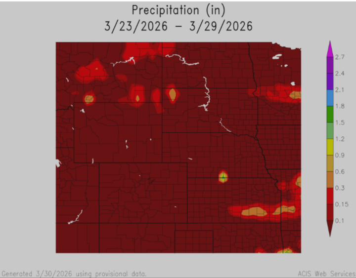
Precipitation across Nebraska this week was minimal overall. Most locations reported little to no measurable rainfall, with only isolated areas receiving trace amounts or up to a few hundredths of an inch from scattered showers early in the week . Even with the passage of the midweek cold front, ensemble guidance suggested only a 15–30% chance of light precipitation, with little accumulation expected. The persistent lack of moisture, combined with gusty winds and low relative humidity, contributed to ongoing near-critical to critical fire weather conditions across much of the state.
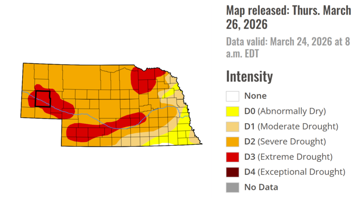
Looking at a similar figure, the U.S. Drought Monitor lists parts of Nebraska under extreme drought, with the majority of the state in severe drought. This is a dangerous time for any type of wildfire activity to occur, especially considering the recent Morrill (Morrill County is outlined in black) and Cottonwood fires that occurred in western Nebraska
Temperature and Precipitation Extremes (Observed/Estimated for the Week):
- Maximum High Temperature: ~90°F, southern Nebraska near Kansas border
- Minimum High Temperature: ~52°F, northern Nebraska
- Minimum Low Temperature: ~28–32°F, northern and northeastern Nebraska
- Maximum Low Temperature: ~45°F, central Nebraska
- Maximum Precipitation: ~0.05", isolated locations in central Nebraska
To wrap things up, this week featured a classic early-spring pattern across Nebraska, characterized by large temperature swings, limited precipitation, and heightened fire-weather concerns. A transition from cool, cloudy conditions early in the week to unseasonably warm and dry weather by midweek was driven by increasing ridging and strong southerly flow. The passage of a late-week cold front briefly cooled temperatures back into the 50s before another warming trend began heading into the weekend. Overall, the lack of meaningful precipitation and persistent dry conditions remain the main concerns moving forward, particularly regarding fire danger across the region.


