
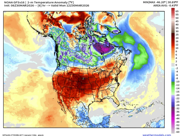
Hello NSCO community, and happy April! This week across Nebraska featured a sharp transition from warmer to much cooler temperatures. Early in the period, strong upper-level ridging over the Central Plains supported widespread above-normal temperatures, with highs soaring into the mid- to upper 80s statewide and even approaching 90°F in parts of southwest Nebraska and the Sandhills. These warm conditions were accompanied by very low relative humidity, especially across western and central Nebraska, where values dropped into the teens, creating elevated to critical fire weather concerns. As the ridge shifted east, a significant pattern change occurred with an incoming trough and associated cold front. This led to a rapid drop in temperatures by Tuesday, with highs falling into the 50s and 60s, representing a 20–30°F decrease from the previous day. Moisture also gradually increased through the latter half of the period as precipitation chances returned.
At the mid-levels, 850 mb temperatures were notably warm at the start of the period, ranging from approximately 68–75°F, supporting efficient boundary layer mixing and the unusually high surface temperatures observed Monday. At 500 mb, weak ridging transitioned to a more active pattern as shortwave troughs propagated through the Plains. This shift to southwesterly flow aloft by midweek enhanced large-scale ascent, allowing moisture to be transported into the region. The combination of these features helped initiate precipitation development, especially as cyclonic vorticity advection increased ahead of embedded disturbances. As colder air filtered in behind the front, thermal profiles became favorable for mixed precipitation across northern Nebraska.
A strong cold front was the dominant surface feature during this period, pushing southward across Nebraska late Monday into early Tuesday. This frontal passage resulted in a sharp wind shift to the north, with gusts frequently reaching 35–50 mph, particularly across eastern and central Nebraska . Ahead of the front, warm and dry conditions persisted, with elevated fire weather risk, especially across western Nebraska and the Sandhills, where Red Flag Warnings were in effect. Behind the front, cooler and more stable conditions developed, though lingering dry air initially limited precipitation reaching the surface. As the week progressed, additional shortwave troughs and a developing surface low contributed to increasing cloud cover and more widespread precipitation chances.
Precipitation across the state was initially limited, with only isolated showers or sprinkles occurring on Monday due to dry low-level air and high cloud bases. However, more meaningful precipitation developed from Tuesday night through Thursday as a series of disturbances moved through the region. Total precipitation amounts generally ranged from 0.25 to 0.75 inches across much of central and eastern Nebraska, with locally higher amounts possible. Northern Nebraska had the potential for light snow or a rain/snow mix, particularly overnight when temperatures approached freezing. Western Nebraska saw lower precipitation totals overall, though even modest moisture was beneficial given ongoing dry conditions and fire weather concerns.
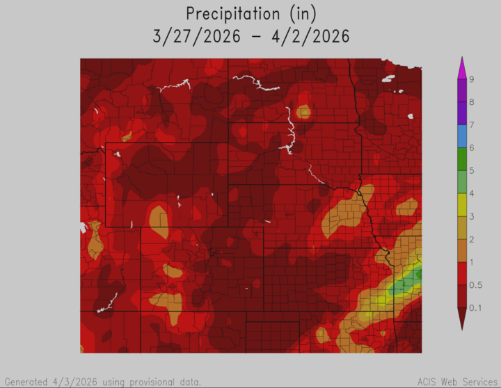
Temperature and precipitation extremes across the state highlighted the volatility of this pattern. Maximum high temperatures reached the upper 80s to near 90°F across southwest Nebraska and portions of the Sandhills early in the week, while minimum highs dropped into the 40s and 50s following the frontal passage. Overnight lows ranged from the upper 20s in northern Nebraska during colder periods to the 40s ahead of the front. The highest precipitation totals were generally observed across central and eastern Nebraska, where several tenths to nearly an inch of liquid equivalent fell during the midweek system. Northern areas experienced minor snow accumulations, generally a trace to a few tenths of an inch.
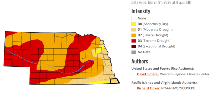
Overall, this week had a transition pattern across Nebraska, shifting from record or near-record warmth and fire weather concerns to a cooler, wetter regime. The initial ridge-driven warmth and dry conditions gave way to a decent storm track, bringing much-needed precipitation to portions of the state. While not a drought-ending event, the rainfall helped alleviate some dryness and temporarily reduced fire weather risks for the area. The outlook for this week may be more favorable for precipitation, specifically snow, in the eastern portion of the state from this Tuesday to Wednesday, so make sure to stay weather-aware going into this week!


