Hello NSCO community! This past week, we experienced some colder temperatures, and snow in some parts of the state. Temperatures across Nebraska this week were cooler overall behind a departing late-weekend system, with highs generally in the upper 30s to mid-40s north (Valentine, O’Neill) and low to mid-40s south (North Platte, McCook, Omaha/Lincoln), which were recorded from the National Weather Service. A chilly, windy Tuesday followed the passage of a cold front, accompanied by strong cold-air advection, which is the transport of cooler air into a surrounding environment. Northwest winds made it feel even colder despite the recorded afternoon readings being in the 40s. Patchy fog and pockets of drizzle and light rain were noted mainly near and east of the Missouri River from Omaha down toward Plattsmouth and into southwest Iowa early Tuesday, while the western Sandhills and panhandle stayed mainly dry. Midweek, a building ridge over the Rockies and a northwesterly flow aloft kept Nebraska on the cool side but mostly dry heading into Thanksgiving.
At 850 mb and 500 mb, the pattern was dominated by northwesterly flow over the central Plains, between a deep trough over the Great Lakes and a ridge building into the western U.S. Early in the period, a compact shortwave trough moved through the Dakotas into Minnesota and Wisconsin, driving the surface low and Tuesday’s strong gradient winds across Nebraska. Behind this, heights slowly rose midweek as ridging nudged eastward, reinforcing dry weather but keeping temperatures near to slightly below late-November normals. By late week, another shortwave dropping out of the Pacific Northwest began to carve out a broader trough over the Rockies, with strengthening 850-mb warm-advection and a ribbon of low- to mid-level frontogenesis setting up from the Dakotas into northeast Nebraska and western Iowa. This is the feature that was poised to focus on a band of snow from Friday into Friday night.
Surface-wise, a strong cold front swept northwest to southeast across Nebraska early Tuesday, switching winds to the northwest and bringing in much colder and drier air. High Wind Warnings were in effect across much of western and north-central Nebraska, including the Sandhills and the I-80 corridor near North Platte and Ogallala, where northwest winds of 30-40 mph with gusts up to 55-60 mph were observed. Farther east, from Norfolk through Omaha and Lincoln into southeast Nebraska, a Wind Advisory highlighted frequent gusts in the 35-50 mph range. Patchy dense fog developed ahead of the front in portions of eastern Nebraska and southwest Iowa, with visibilities occasionally dropping below 1/4 mile before rapidly improving as the front pushed through. The remainder of the week remained calm, but attention shifted to a developing surface low over eastern Colorado and Kansas late Friday into Saturday, which brought another cold front and a wintry mix into the region.
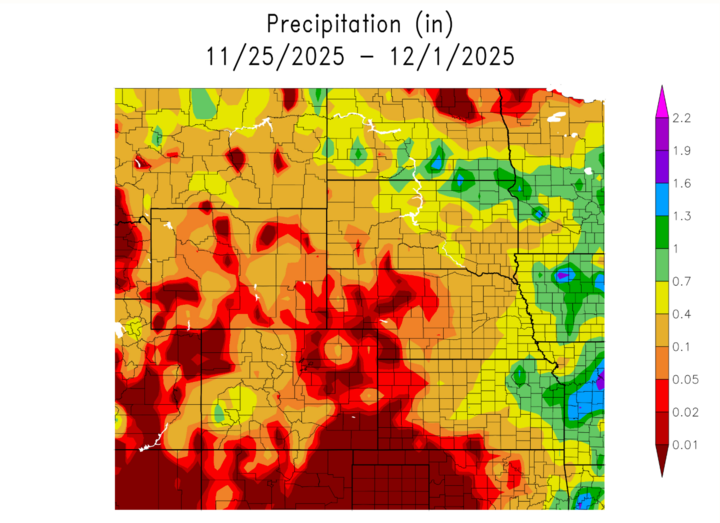
Precipitation this week began with lingering drizzle and light rain on Monday into early Tuesday over eastern Nebraska, quickly ending as the upper wave moved east and drier air moved in. The main focus for the latter half of the week was on the end of the week. A heavy band of snow was setting up from South Dakota into northeast Nebraska and western Iowa on Friday, with the best chance for accumulating snow (around 1 inch or more) in counties from near Norfolk and Wayne up toward the Knox/Cedar area and into west-central Iowa. As the Colorado low deepened and tracked east-southeast on Friday night into Saturday, precipitation became more widespread, starting as snow north of I-80 and transitioning to a mix of rain and snow, with a greater rain component toward the Kansas border, before finally becoming all snow as colder air wrapped in from the northwest. Below gives a good example of where Nebraska experienced the most precipitation, with the heaviest bands being in the southeast part of the state. I wanted to showcase the drought monitor for the state as well from the Nebraska Integrated Drought Information System (NIDIS) which shows that the state is still experiencing slight drought conditions in the central portion.

I also wanted to include some maximum and minimum temperatures, as well as any precipitation anomolies noted for the state this past week:
Temperature and Precipitation Extremes (example for this period)
(Based on data from the Applied Climate Information Services from November 23-29)
Maximum High Temperature: 68°F, Valentine Miller Field
Minimum High Temperature: 20°F , Valentine Miller Field
Minimum Low Temperature: -9°F , Chadron Municipal Airpott
Maximum Low Temperature: 48°F. York
Highest 24-hr Precipitation / Liquid Equivalent: 0.87", Falls City 4 NE
Highest Snowfall: 7.3", Gretna 2.9 NNE
In summary, Nebraska transitioned from a windy, sharply colder post-frontal regime early in the week to a quieter but cool midweek period, before turning active again on Friday into the weekend as a Colorado low brought accumulating snow, mixed precipitation, and another surge of Arctic air into the state. Looking ahead, ensemble guidance favors highs mainly in the teens and 20s, and lows in the single digits and teens, continuing into early this week. Wind chills are expected to occasionally dip below zero before gradually moderating back into the 30s by midweek.