
Hello from the NSCO community! This week in Nebraska, we experienced a ridge that brought quiet, mild conditions across much of the state, with highs ranging from the low to mid-60s on Monday and into the low 70s on Tuesday for much of eastern Nebraska. A gradual cooling trend then followed into the weekend. Low-level humidity was generally limited through midweek, so most days remained dry through Thursday. However, relative humidity levels did drop, and gusty winds on Thursday and Friday created an elevated fire-weather concern in parts of northeast Nebraska. By Saturday, a stronger, multi-wave pattern dug into the Northern Plains and advected cooler air southward, producing a notable temperature fall late Saturday into Sunday.
Mid-level flow evolved from a zonal weak ridging setup early in the week and amplified to a trough by the weekend. Several shortwaves coming from the Rockies produced lee cyclogenesis and a surface low track for the Nebraska, and South Dakota border through Saturday. Strong low-level warm-air advection ahead of the baroclinic zone on Tuesday led to the Tuesday warmup (upper 60s to low 70s), while later cold-air advection and tightening thicknesses with the Saturday system forced the rapid cool-down and mixed precipitation in the far north and east of Nebraska on Saturday.
Surface analysis indicated a cold front exiting to our east on Monday, followed by another stronger cold front and the development of a surface low approaching late Friday into Saturday. We will be expecting gusty northerly winds in the wake of frontal passages (gusts between 25–35 kt reported/forecast behind some fronts). The highest winter precipitation amounts did not fall in Nebraska; the northeastern portion of the state experienced upwards of 1-2 inches of snowfall, with the warm sector showing scattered showers along the front in eastern counties and limited forcing farther west. Overall, Precipitation coverage for the week was modest, with the highest chances focused across northeast Nebraska, with expected totals generally light
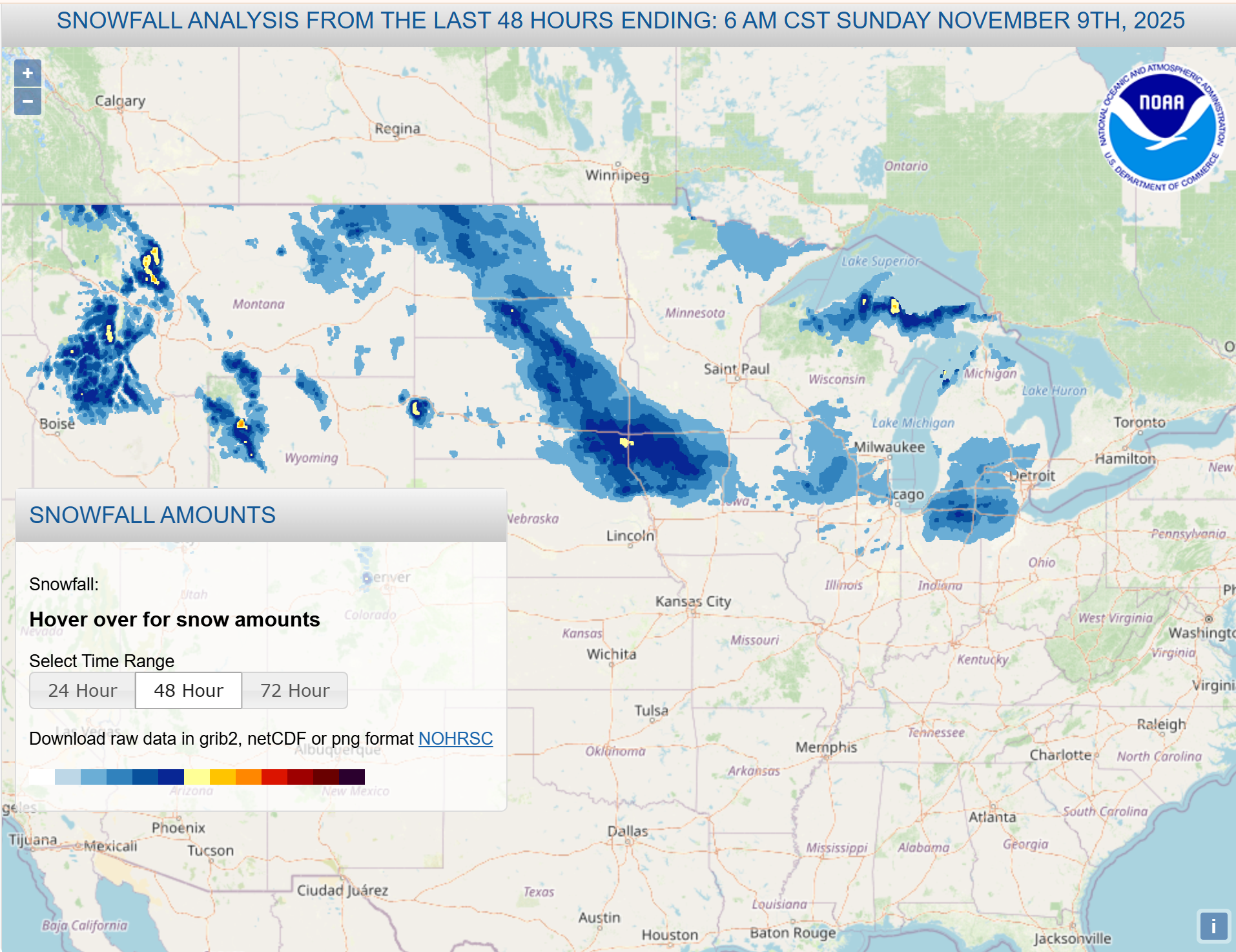
The warmest midweek readings for the state were near 70–72°F in southeast/eastern sites of Nebraska near the Kansas border. In contrast, the coolest post-front highs on Sunday were only in the 30s across most of the state, and the lowest overnight lows from Sunday through Monday were in the teens to low-20s in many locations. No significant impacts were expected from the accumulative snowfall amounts yesterday.
For this past week, it was quiet and mild early (low-mid 60s to low 70s, and dry air), breezy Thursday through Friday with elevated fire danger in parts of northeast Nebraska, then interesting weather day on Saturday with a surface low and cold front bringing rain chances (highest in northeast NE) and a rapid cooldown to much colder air Sunday through Monday and throughout the remainder of the week.
Temperature and Precipitation Roundup
Maximum Daily High Temperature: 85°F, Imperial Municipal AP
Minimum Daily High Temperature: 38°F, Tekamah Municipal AP
Minimum Daily Low Temperature: 13°F, Lodgepole 8 N
Maximum Daily Low Temperature: 46°F, Valley NWS
Maximum Weekly Precipitation: 0.50”, Hartington 0.5 NW
Maximum Snowfall: 2.5”, Concord
| Site | Type | Avg High | Avg Low | Average | MaxT | MinT | Precip | Snow | HDD | CDD |
| AINSWORTH | COOP | 63.3 | 20.0 | 48.7 | 80 | 20 | 0.06 | M | 112 | 0 |
| ALBION | COOP | 61.1 | 31.0 | 47.6 | 74 | 31 | 0 | 0 | 120 | 0 |
| ALLIANCE MUNICIPAL AIRPORT ASOS | WBAN | 64.3 | 17.0 | 44.4 | 80 | 17 | T | M | 141 | 0 |
| ARTHUR | COOP | 65.0 | 13.0 | 47.1 | 81 | 13 | 0.02 | M | 124 | 0 |
| AUBURN 5 ESE | COOP | 62.0 | 27.0 | 47.1 | 69 | 27 | 0 | 0 | 125 | 0 |
| AURORA MUNICIPAL AP | WBAN | 64.0 | 31.0 | 49.0 | 74 | 31 | 0.02 | M | 110 | 0 |
| BRADY | COOP | 68.3 | 29.0 | 50.4 | 82 | 29 | 0 | 0 | 100 | 0 |
| BROKEN BOW MUNICIPAL AP | WBAN | 64.7 | 26.0 | 47.6 | 82 | 26 | 0.02 | M | 120 | 0 |
| BUSHNELL 15S | COOP | 61.7 | 19.0 | 42.7 | 76 | 19 | T | 0 | 154 | 0 |
| CALLAWAY 8WSW | COOP | 65.9 | 24.0 | 50.5 | 82 | 24 | 0 | 0 | 100 | 0 |
| CAMBRIDGE | COOP | 64.4 | 23.0 | 46.1 | 82 | 23 | 0 | 0 | 130 | 0 |
| CANADAY STEAM PLANT | COOP | 65.0 | 26.0 | 49.4 | 80 | 26 | 0 | 0 | 108 | 0 |
| CHADRON 3SW | COOP | 67.7 | 16.0 | 44.6 | 80 | 16 | 0.09 | 0 | 141 | 0 |
| CHADRON MUNICIPAL AP | WBAN | 64.3 | 21.0 | 46.4 | 79 | 21 | 0.07 | M | 129 | 0 |
| CLAY CENTER | COOP | 63.1 | 29.0 | 47.9 | 71 | 29 | 0 | 0 | 117 | 0 |
| COLUMBUS | WBAN | 62.6 | 24.0 | 46.9 | 73 | 24 | 0.02 | M | 124 | 0 |
| COLUMBUS 3 NE | COOP | 60.7 | 29.0 | 48.1 | 71 | 29 | 0.01 | 0 | 118 | 0 |
| CONCORD | COOP | 61.6 | 26.0 | 48.1 | 69 | 26 | M | M | 117 | 0 |
| CRETE 4ESE | COOP | 63.3 | 30.0 | 50.6 | 71 | 30 | 0 | 0 | 98 | 0 |
| CULBERTSON | COOP | 64.7 | 22.0 | 47.6 | 82 | 22 | 0 | 0 | 120 | 0 |
| CURTIS | COOP | 73.1 | 22.0 | 52.1 | 83 | 22 | 0 | 0 | 90 | 0 |
| EDISON | COOP | 65.9 | 21.0 | 46.2 | 84 | 21 | 0 | 0 | 130 | 0 |
| ELGIN | COOP | 60.3 | 29.0 | 47.6 | 72 | 29 | 0 | 0 | 120 | 0 |
| ERICSON 8 WNW | COOP | 64.3 | 31.0 | 49.7 | 76 | 31 | 0.02 | M | 106 | 0 |
| EUSTIS 2 NW | COOP | 64.1 | 28.0 | 49.3 | 82 | 28 | 0 | 0 | 109 | 0 |
| FAIRBURY 7S | COOP | 62.1 | 26.0 | 49.6 | 69 | 26 | 0 | 0 | 106 | 0 |
| FALLS CITY 4NE | COOP | 62.4 | 22.0 | 48.5 | 69 | 22 | T | M | 114 | 0 |
| FALLS CITY BRENNER FIELD | WBAN | 62.7 | 27.0 | 49.1 | 69 | 27 | 0.02 | M | 110 | 0 |
| FREMONT | COOP | 62.1 | 30.0 | 49.1 | 71 | 30 | 0.09 | 0 | 109 | 0 |
| FRIEND 3E | COOP | 61.6 | 28.0 | 48.2 | 71 | 28 | T | 0 | 117 | 0 |
| GRAND ISLAND CENTRAL NE REGIONAL AP | WBAN | 63.7 | 29.0 | 49.1 | 75 | 29 | T | 0 | 109 | 0 |
| GREELEY | COOP | 62.0 | 29.0 | 48.1 | 75 | 29 | T | 0 | 116 | 0 |
| GRETNA | COOP | 59.9 | 30.0 | 48.3 | 69 | 30 | 0.07 | 0 | 115 | 0 |
| HARRISBURG 12WNW | COOP | 66.1 | 14.0 | 44.9 | 78 | 14 | 0 | M | 140 | 0 |
| HARRISON 20 SSE | WBAN | 63.3 | 14.0 | 42.3 | 77 | 14 | 0.04 | M | 158 | 0 |
| HASTINGS 4N | COOP | 62.6 | 29.0 | 48.6 | 72 | 29 | 0.01 | T | 113 | 0 |
| HASTINGS MUNICIPAL AIRPORT | WBAN | 63.1 | 30.0 | 49.6 | 73 | 30 | T | T | 106 | 0 |
| HAYES CENTER 1NW | WBAN | 66.3 | 23.0 | 49.4 | 83 | 23 | 0 | 0 | 108 | 0 |
| HEBRON | COOP | 62.0 | 28.0 | 48.6 | 68 | 28 | 0 | 0 | 113 | 0 |
| HEBRON MUNICIPAL AP | WBAN | 63.7 | 27.0 | 48.9 | 69 | 27 | T | M | 110 | 0 |
| HOLDREGE | COOP | 63.6 | 27.0 | 49.4 | 74 | 27 | 0 | 0 | 106 | 0 |
| HOLDREGE BREWSTER FIELD AP | WBAN | 63.9 | 32.0 | 49.2 | 75 | 32 | T | M | 108 | 0 |
| IMPERIAL | COOP | 67.9 | 19.0 | 49.1 | 84 | 19 | 0 | 0 | 110 | 0 |
| IMPERIAL MUNICIPAL AP | WBAN | 69.1 | 28.0 | 50.6 | 85 | 28 | 0 | M | 100 | 0 |
| KEARNEY 4 NE | COOP | 63.0 | 27.0 | 48.8 | 74 | 27 | M | 0 | 111 | 0 |
| KEARNEY MUNICIPAL AP | WBAN | 63.7 | 31.0 | 48.6 | 74 | 31 | T | M | 112 | 0 |
| KILGORE 1NE | COOP | 66.3 | 28.0 | 49.2 | 80 | 28 | 0.01 | 0 | 108 | 0 |
| KINGSLEY DAM | COOP | 63.9 | 29.0 | 49.9 | 77 | 29 | 0 | 0 | 104 | 0 |
| LEXINGTON JIM KELLY FIELD | WBAN | 67.0 | 29.0 | 49.7 | 82 | 29 | 0 | M | 105 | 0 |
| LINCOLN 11 SW | WBAN | 63.0 | 31.0 | 49.8 | 71 | 31 | 0.02 | M | 105 | 0 |
| LINCOLN 8 ENE | WBAN | 63.1 | 31.0 | 48.5 | 72 | 31 | 0.05 | M | 113 | 0 |
| LINCOLN AIRPORT | WBAN | 63.4 | 26.0 | 47.6 | 71 | 26 | 0.06 | 0 | 119 | 0 |
| LODGEPOLE 8N | COOP | 66.1 | 13.0 | 45.7 | 82 | 13 | T | 0 | 133 | 0 |
| MCCOOK MUNICIPAL AP | WBAN | 65.3 | 29.0 | 49.0 | 82 | 29 | T | M | 111 | 0 |
| MEAD 6S | COOP | 62.3 | 26.0 | 48.3 | 71 | 26 | 0.04 | 0 | 114 | 0 |
| NEBRASKA CITY 2NW | COOP | 61.7 | 31.0 | 48.7 | 68 | 31 | 0 | 0 | 112 | 0 |
| NORFOLK KARL STEFAN MEMORIAL AP | WBAN | 61.1 | 27.0 | 46.5 | 72 | 27 | 0.09 | T | 128 | 0 |
| NORTH LOUP | COOP | 62.1 | 32.0 | 47.9 | 75 | 32 | 0 | 0 | 119 | 0 |
| NORTH PLATTE 3ENE | COOP | 66.1 | 27.0 | 48.7 | 81 | 27 | T | 0 | 112 | 0 |
| NORTH PLATTE REGIONAL AP | WBAN | 67.3 | 24.0 | 48.4 | 82 | 24 | T | 0 | 114 | 0 |
| O'NEILL | COOP | 60.4 | 27.0 | 47.1 | 74 | 27 | 0.06 | M | 124 | 0 |
| OGALLALA | COOP | 68.4 | 18.0 | 48.9 | 82 | 18 | 0 | 0 | 111 | 0 |
| OMAHA EPPLEY AIRFIELD | WBAN | 59.9 | 32.0 | 47.5 | 69 | 32 | 0.14 | 0 | 122 | 0 |
| ORD EVELYN SHARP FIELD | WBAN | 63.1 | 28.0 | 47.4 | 76 | 28 | 0.03 | M | 122 | 0 |
| OSCEOLA | COOP | 61.7 | 33.0 | 49.9 | 73 | 33 | T | 0 | 102 | 0 |
| OXFORD 6NNW | COOP | 64.7 | 27.0 | 48.6 | 82 | 27 | 0 | 0 | 113 | 0 |
| PLAINSVIEW RANCH | COOP | 64.1 | 18.0 | 45.5 | 77 | 18 | T | M | 135 | 0 |
| RAVENNA | COOP | 63.0 | 29.0 | 47.7 | 77 | 29 | 0 | 0 | 119 | 0 |
| SCOTTSBLUFF 1E | COOP | 67.0 | 16.0 | 47.6 | 79 | 16 | T | M | 121 | 0 |
| SCOTTSBLUFF W B HEILIG FIELD AP | WBAN | 65.9 | 23.0 | 46.3 | 80 | 23 | T | M | 130 | 0 |
| SEWARD | COOP | 62.6 | 29.0 | 49.1 | 70 | 29 | 0.02 | 0 | 110 | 0 |
| SIDNEY MUNICIPAL AP | WBAN | 64.9 | 18.0 | 45.9 | 81 | 18 | 0 | M | 133 | 0 |
| SPRINGVIEW 2NW | COOP | 63.6 | 25.0 | 47.6 | 79 | 25 | 0.04 | T | 120 | 0 |
| STANTON 7NE | COOP | 60.6 | 25.0 | 47.0 | 70 | 25 | 0.15 | 0 | 124 | 0 |
| STAPLETON 5W | COOP | 65.4 | 29.0 | 48.6 | 81 | 29 | T | 0 | 113 | 0 |
| SUPERIOR | COOP | 64.4 | 23.0 | 48.4 | 71 | 23 | 0 | 0 | 114 | 0 |
| SYRACUSE | COOP | 62.9 | 25.0 | 47.9 | 71 | 25 | T | 0 | 117 | 0 |
| TABLE ROCK 4N | COOP | 62.3 | 28.0 | 49.1 | 69 | 28 | 0 | 0 | 109 | 0 |
| TEKAMAH MUNICIPAL AP | WBAN | 59.6 | 24.0 | 44.7 | 69 | 24 | 0.17 | M | 141 | 0 |
| TRENTON DAM 1N | COOP | 68.0 | 24.0 | 49.9 | 86 | 24 | 0 | M | 104 | 0 |
| VALENTINE MILLER FIELD AP | WBAN | 63.7 | 26.0 | 48.1 | 80 | 26 | 0.1 | T | 117 | 0 |
| VALENTINE NO. 1 | COOP | 62.3 | 22.0 | 47.1 | 78 | 22 | 0.09 | M | 124 | 0 |
| VALENTINE NWR | COOP | 71.7 | 34.0 | 54.9 | 82 | 34 | 0 | 0 | 68 | 0 |
| VALLEY NWS | COOP | 60.6 | 32.0 | 49.4 | 70 | 32 | 0.09 | 0 | 107 | 0 |
| WAKEFIELD 3NW | COOP | 61.0 | 25.0 | 46.4 | 71 | 25 | 0.45 | 0 | 128 | 0 |
| WEST POINT | COOP | 60.1 | 29.0 | 46.9 | 70 | 29 | 0.13 | 0 | 124 | 0 |
| WHITMAN 5 ENE | WBAN | 63.1 | 27.0 | 49.1 | 78 | 27 | 0 | M | 109 | 0 |
| YORK | WBAN | 62.7 | 28.0 | 48.6 | 72 | 28 | 0.03 | M | 113 | 0 |
| YORK 3N | COOP | 63.3 | 26.0 | 48.4 | 74 | 26 | 0.01 | 0 | 115 | 0 |


