
Hello NSCO community! We have had quite an eventful set of weather events this past week. Nebraska had a sharp transition to cooler, and wetter conditions as a deep trough moved through the Central Plains. Temperatures early in the week were in the mid to upper 50s before dropping into the upper 40s and low 50s behind a strong cold front. Widespread rainfall developed Monday night into Tuesday, bringing totals of 0.25 to 0.75 inches across much of eastern Nebraska, with heavier amounts near the Missouri River and western Iowa. Breezy northwesterly winds persisted through midweek, with gusts frequently between 30–40 mph. By late week, skies began to clear, allowing overnight lows to dip below freezing, marking the first widespread freeze of the season across much of the state. A gradual warming trend followed the weekend under a high-pressure system.
At the 500 mb level, a closed low developed early in the week over the southern Plains before lifting northeast into Missouri, enhancing upper-level divergence and widespread precipitation across Nebraska. By Tuesday, a strong trough axis and embedded shortwave pivoted across the region, deepening the cold front and producing robust northwesterly flow aloft. The 850 mb winds strengthened 40–50 knots behind the front, supporting strong surface gusts as the pressure gradient tightened. Later in the week, the flow became more northwesterly, promoting continued cold advection. By the weekend, a weak ridge began to build over the central Plains, signaling the start of a warming trend.
As mentioned before, and getting into more detail, a well-defined cold front crossed the state Monday night into Tuesday, bringing widespread rainfall and a significant temperature drop. Post-frontal air ushered in much cooler and drier conditions, with highs struggling to reach 50°F midweek. The front’s passage was followed by a surge of northwesterly winds, occasionally gusting above 35 mph. By Thursday morning, a surface high built in from the west, and calming winds produced widespread fog and localized freezing fog in eastern Nebraska and western Iowa. By Friday, another weak boundary pushed through northern Nebraska, bringing only isolated sprinkles or flurries near the South Dakota border.
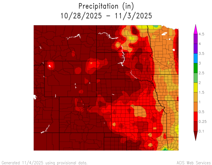
Rainfall totals for the week were generally light to moderate, averaging between 0.25 and 1 inch across the state. The heaviest amounts were observed in far eastern Nebraska into southwest Iowa, where showers lingered longest. Precipitation tapered off westward, with totals below 0.25 inches in the central portions of the state. Later in the week, drier air and rising surface pressure brought several clear and cold nights, allowing fog development but minimal new precipitation. I would like to tack on a ACIS map showcasing the slightly higher levels of rainfall seen in the eastern portion of the state, compared to the western portion with values between 0.25-1 inches
Below are the maximum and minimum temperatures recorded in the state for various regions of Nebraska:
Maximum High Temperature: 63°F, McCook
Minimum High Temperature: 47°F, Norfolk
Minimum Low Temperature: 25°F, Columbus
Maximum Low Temperature: 44°F, Omaha
The week of October 27th marked the arrival of late-fall conditions across Nebraska. A deep upper-level trough and associated cold front brought widespread rainfall, gusty winds, and a pronounced cooldown. By midweek, the first widespread freeze occurred across eastern and central Nebraska, followed by morning fog and patchy frost. High pressure and a weak ridge pattern will promote warming into the 60s by early next week, with mostly dry weather expected. Looking ahead, the next chance for precipitation appears late this week as another shortwave system approaches the central Plains.


