
Hello from the NSCO community, and happy late October! I don’t know if this has just been me, but this month really has flown by. Apologies for the late weekly posting; much of my time has been spent making the monthly summary for the month of September (if you haven’t checked it out, I would recommend reading through!). Anyways, looking back at this previous week across Nebraska, we saw a classic fall pattern transition, with temperatures trending cooler behind a strong cold front early in the week. Highs started out in the mid-50s to low-60s statewide, with cooler air filtering in from the northwest behind Monday’s frontal passage regarding the cold front. Humidity values dropped to 25–35%, particularly across eastern and southern portions of Nebraska, leading to elevated fire danger during ongoing harvest operations. The strongest winds were seen Monday and Tuesday, with gusts of 35–45 mph, especially in northeast and central Nebraska. As high pressure settled in midweek, calmer conditions and clear skies returned, allowing frost and even some localized freezes across the northeast and central parts of the state to occur.
At the 850mb level, the cold advection behind the front was evident early in the week, with temperatures dropping at least several degrees Celsius as a mid-level trough moved eastward. By Wednesday, an 850mb ridge developed overhead, supporting light winds and efficient radiational cooling overnight. Meanwhile, the 500mb pattern showcased a mid-level trough swinging through the north-central U.S. Monday into Tuesday, followed by a transient ridge midweek, and a weaker southern-stream trough approaching from the southern Plains late in the week. These upper-level features are tied to the temperature shift and precipitation chances later in the week.
A cold front swept across the state on Monday, marking the shift from mild and windy to cooler, drier air. Behind this front, strong northwest winds dominated through Tuesday before high pressure settled in midweek. The frontal boundary then stalled well to the south, with a southern low-pressure system moving into the Southern Plains. This feature brought rain to parts of south central, southeast Nebraska and southwest Iowa late Thursday into Friday, while most of the state remained dry. For the most part, though, precipitation was minimal statewide this week, with most areas recording only light showers or sprinkles early and late in the week. The highest totals were between Sutton and Red Cloud where some locations had over an inch. The rest of the state generally saw less than 0.05 inches of precipitation and many places saw no precipitation. Below is a figure depicting total rain for the state this past week.
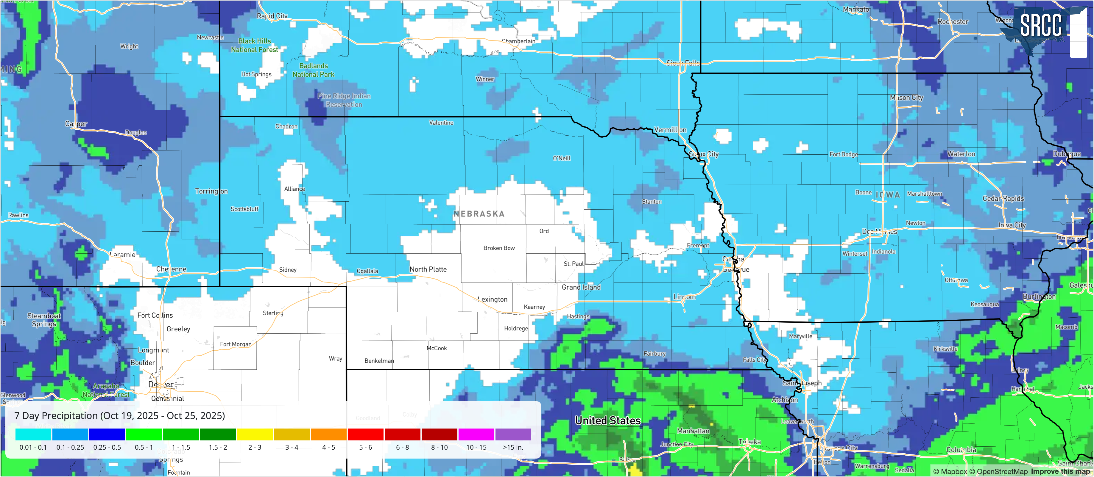
Figure 1. Total precipitation last week
Overall, the week of October 20th brought a seasonal shift across Nebraska with cooler days, nights that are bringing frost, and more limited rainfall. The state experienced a sharp temperature gradient early in the week under northwest flow, followed by tranquil conditions midweek and a brief return of light precipitation late in the week. Looking ahead, ensemble outlooks for the final week of October suggest continued seasonable temperatures, highs mostly in the 50s and 60s, with a renewed chance for showers early this week as another trough approaches from the west.
Temperature and Precipitation Roundup
Maximum High Temperature: 80°F, Harrisburg 12 WNW
Minimum High Temperature: 50°F, O'Neill
Minimum Low Temperature: 17°F, Harrison 20 SSE
Maximum Low Temperature: 51°F, Valley NWS
Maximum Precipitation: 1.70", Glenvil 2.3 WSW
| Location | Avg High | Avg Low | Average | Precip | Tmax | Tmin | HDD | CDD |
| AINSWORTH | 62.7 | 37.7 | 50.2 | 0.00 | 68 | 33 | 101 | 0 |
| ALBION | 61.0 | 35.1 | 48.1 | 0.00 | 66 | 28 | 116 | 0 |
| ALLIANCE MUNICIPAL AIRPORT ASOS | 68.4 | 23.6 | 46.0 | 0.00 | 78 | 18 | 131 | 0 |
| ARTHUR | 63.6 | 30.9 | 47.2 | 0.00 | 73 | 24 | 123 | 0 |
| AUBURN 5 ESE | 63.9 | 38.0 | 50.9 | 0.06 | 75 | 31 | 97 | 0 |
| AURORA MUNICIPAL AP | 62.7 | 37.9 | 50.3 | 0.05 | 68 | 31 | 101 | 0 |
| BROKEN BOW MUNICIPAL AP | 61.4 | M | M | 0.00 | 67 | M | M | M |
| BURWELL 2WSW | 60.0 | 31.4 | 45.7 | 0.00 | 65 | 27 | 133 | 0 |
| CAMBRIDGE | 64.9 | 31.4 | 48.1 | 0.00 | 71 | 28 | 116 | 0 |
| CANADAY STEAM PLANT | 63.9 | 32.4 | 48.1 | M | 70 | 28 | 117 | 0 |
| CHADRON MUNICIPAL AP | 67.7 | 27.9 | 47.8 | T | 77 | 23 | 118 | 0 |
| COLUMBUS | 61.6 | 36.0 | 48.8 | T | 66 | 28 | 112 | 0 |
| COLUMBUS 3 NE | 61.9 | 40.6 | 51.2 | 0.00 | 66 | 33 | 95 | 0 |
| CRETE 4ESE | 64.9 | 41.0 | 52.9 | 0.06 | 72 | 35 | 83 | 0 |
| CULBERTSON | 66.6 | 32.0 | 49.3 | 0.00 | 89 | 30 | 108 | 0 |
| EDISON | 66.0 | 28.4 | 47.2 | 0.01 | 71 | 23 | 122 | 0 |
| ELGIN | 61.3 | 38.0 | 49.6 | 0.00 | 65 | 33 | 107 | 0 |
| ERICSON 8 WNW | 63.4 | 35.0 | 49.2 | 0.00 | 67 | 28 | 109 | 0 |
| EUSTIS 2 NW | 63.0 | 34.9 | 48.9 | 0.00 | 69 | 29 | 111 | 0 |
| FALLS CITY BRENNER FIELD | 63.0 | 41.3 | 52.1 | 0.09 | 69 | 34 | 88 | 0 |
| FREMONT | 64.0 | 39.1 | 51.6 | 0.00 | 68 | 33 | 92 | 0 |
| FRIEND 3E | 63.3 | 37.4 | 50.4 | 0.06 | 67 | 34 | 100 | 0 |
| GRAND ISLAND CENTRAL NE REGIONAL AP | 62.7 | 37.9 | 50.3 | 0.02 | 68 | 28 | 101 | 0 |
| GREELEY | 61.9 | 34.0 | 47.9 | 0.07 | 67 | 25 | 117 | 0 |
| HARRISBURG 12WNW | 65.0 | 24.3 | 44.6 | 0.09 | 80 | 20 | 142 | 0 |
| HARRISON 20 SSE | 67.7 | 19.0 | 43.4 | 0.01 | 76 | 17 | 149 | 0 |
| HASTINGS 4N | 61.3 | 38.7 | 50.0 | 0.07 | 67 | 32 | 103 | 0 |
| HASTINGS MUNICIPAL AIRPORT | 62.1 | 38.9 | 50.5 | 0.01 | 67 | 32 | 100 | 0 |
| HAYES CENTER 1NW | 63.7 | 33.0 | 48.4 | 0.00 | 69 | 31 | 115 | 0 |
| HEBRON | 65.1 | 37.0 | 51.1 | 0.31 | 70 | 32 | 95 | 0 |
| HEBRON MUNICIPAL AP | 63.7 | 39.3 | 51.5 | 0.35 | 70 | 31 | 93 | 0 |
| HOLDREGE | 63.4 | 35.3 | 49.4 | 0.02 | 69 | 30 | 108 | 0 |
| HOLDREGE BREWSTER FIELD AP | 63.3 | 39.0 | 51.1 | 0.00 | 69 | 31 | 95 | 0 |
| IMPERIAL | 65.0 | 31.7 | 48.4 | 0.00 | 71 | 30 | 113 | 0 |
| IMPERIAL MUNICIPAL AP | 65.4 | 33.7 | 49.6 | 0.00 | 72 | 30 | 106 | 0 |
| KEARNEY MUNICIPAL AP | 62.6 | 37.6 | 50.1 | T | 68 | 30 | 103 | 0 |
| LEXINGTON JIM KELLY FIELD | 62.9 | 34.3 | 48.6 | 0.00 | 69 | 27 | 113 | 0 |
| LINCOLN 11 SW | 63.1 | 40.3 | 51.7 | 0.04 | 68 | 32 | 91 | 0 |
| LINCOLN 8 ENE | 63.7 | 38.4 | 51.1 | 0.04 | 68 | 29 | 97 | 0 |
| LINCOLN AIRPORT | 63.3 | 38.4 | 50.9 | 0.04 | 68 | 29 | 96 | 0 |
| MCCOOK MUNICIPAL AP | 63.7 | 36.4 | 50.1 | 0.00 | 70 | 30 | 102 | 0 |
| MINDEN | 64.0 | 33.6 | 48.8 | 0.05 | 69 | 30 | 111 | 0 |
| NEBRASKA CITY 2NW | 65.3 | 39.6 | 52.4 | 0.00 | 72 | 34 | 86 | 0 |
| NORFOLK KARL STEFAN MEMORIAL AP | 62.1 | 36.3 | 49.2 | 0.00 | 66 | 26 | 109 | 0 |
| NORTH LOUP | 62.0 | 32.7 | 47.4 | 0.00 | 66 | 26 | 123 | 0 |
| NORTH PLATTE REGIONAL AP | 64.4 | 32.1 | 48.3 | 0.01 | 69 | 26 | 115 | 0 |
| O'NEILL | 58.1 | 34.9 | 46.5 | 0.00 | 64 | 31 | 128 | 0 |
| OMAHA EPPLEY AIRFIELD | 63.7 | 42.0 | 52.9 | T | 67 | 35 | 83 | 0 |
| ORD EVELYN SHARP FIELD | 61.1 | 34.0 | 47.6 | 0.00 | 67 | 24 | 120 | 0 |
| RAVENNA | 63.6 | 32.7 | 48.1 | 0.00 | 68 | 27 | 117 | 0 |
| SCOTTSBLUFF W B HEILIG FIELD AP | 68.7 | 26.7 | 47.7 | T | 80 | 23 | 119 | 0 |
| SEWARD | 64.3 | 37.1 | 50.7 | 0.03 | 69 | 32 | 99 | 0 |
| SIDNEY MUNICIPAL AP | 67.3 | 25.6 | 46.4 | T | 73 | 24 | 128 | 0 |
| SPRINGVIEW 2NW | 62.3 | 32.3 | 47.3 | T | 68 | 29 | 122 | 0 |
| SUPERIOR | 66.9 | 34.3 | 50.6 | 0.22 | 72 | 29 | 100 | 0 |
| SYRACUSE | 64.9 | 37.4 | 51.1 | T | 72 | 30 | 95 | 0 |
| TABLE ROCK 4N | 66.0 | 37.3 | 51.6 | 0.01 | 75 | 32 | 92 | 0 |
| TEKAMAH MUNICIPAL AP | 63.4 | 36.9 | 50.1 | 0.00 | 66 | 28 | 103 | 0 |
| TRENTON DAM 1N | 65.7 | 33.4 | 49.6 | T | 71 | 30 | 107 | 0 |
| VALENTINE MILLER FIELD AP | 65.3 | 30.9 | 48.1 | T | 73 | 25 | 117 | 0 |
| VALENTINE NWR | 66.1 | 38.9 | 52.5 | 0.00 | 71 | 33 | 86 | 0 |
| WAKEFIELD 3NW | 63.3 | 34.7 | 49.0 | 0.00 | 66 | 28 | 110 | 0 |
| WALLACE 2W | 63.7 | 30.0 | 46.9 | T | 69 | 28 | 125 | 0 |
| WEST POINT | 64.3 | 36.6 | 50.4 | 0.01 | 74 | 30 | 100 | 0 |
| WHITMAN 5 ENE | 63.7 | 35.0 | 49.4 | 0.00 | 71 | 31 | 107 | 0 |
| YORK | 62.0 | 38.4 | 50.2 | 0.01 | 68 | 30 | 102 | 0 |


