Summary
This week in Nebraska we featured a notable change from cool, damp conditions early in the week to a brief warm-up midweek before multiple cold-front infiltrations late in the week. Early in the week (Oct 13–14), highs were generally in the 50s–60s across much of Nebraska with increasing cloud cover and spotty light rain developing from western into central and eastern parts of the state. Midweek (Oct 15–16) southerly low-level flow returned warm air advection, which produced 70s into the low-80s across much of eastern Nebraska before a cold front brought cooler air late in the week. Humidity followed that same story with higher relative humidity and low-stratus/fog north of the warm front early on, then lower dew points with gusty winds behind the late-week fronts. Dew points peaked on Wednesday when parts of eastern Nebraska had dew points around 70°F (Figure 1).

Figure 1. Maximum dew point temperatures at Nebraska Mesonet stations last Wednesday
Upper-air analysis from pivotal weather showed mid/upper troughing digging in over the Interior West with a progressive shortwave energy ejecting northeast into the Plains (Figure 2). At 850 mb, periods of southerly to south-southeasterly flow advected warmer, moister air northward ahead of the mid/upper troughs, aiding the mid-week warm sector. A mid/upper jet-streak and associated PVA (positive vorticity direction) provided midlevel lift at times, enough for light, elevated showers and a few embedded rumbles of thunder where MUCAPE (although limited) was present. When the troughs ejected and cold fronts crossed the state, 500 mb heights fell and the column mixed, producing 850mb cooler surface temperatures and gusty northwesterlies.
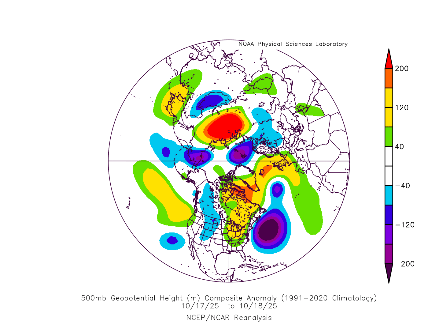
Figure 2. 500-mb height anomalies last Friday and Saturday
The period featured a warm front lifting through southern Nebraska early–midweek, producing low stratus and fog north of it, with light rain/drizzle along and north of that boundary. A primary cold front raced through late Thursday/Friday, producing a quick band of showers and isolated thunderstorms; that frontal band was fast-moving and produced only modest accumulations. A reinforcing cold front followed Saturday into Sunday, bringing gusty winds and dropping highs back into the 60s with pockets of patchy frost possible in northeastern Nebraska early Sunday morning.
Overall precipitation amounts this week were light and spatially limited, with most locations picking up only a few hundredths of an inch to a few tenths. Forecast text and model guidance cited widespread area totals on the order of ~0.05–0.15 inches in many places with much of the state seeing only a trace to a few hundredths from the quick frontal passings. I created an precipitation summary chart for Oct 13th to the 17th (separate time series for western, central, and eastern Nebraska). These are illustrative summaries derived from the AFD’s qualitative totals. The plots are shown below (generated with Python).
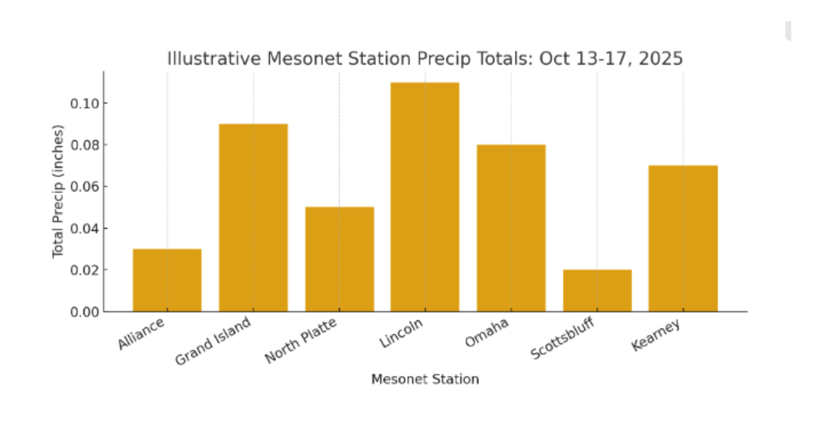
Figure 3. Precipitation totals last week at select stations
This week’s extremes leaned toward a moderate warm spike midweek and chilly lows with patchy frost later in the week. In short, light rain chances were given early and late in the week, due to a warm midweek surge from southerly 850 mb advection, then a quick-moving cold front knocked temperatures back down with gusty winds and resulted in frost for the northeast areas of the state. Looking ahead, the pattern favors additional fronts for the coming week.
Temperature and Precipitation Summary Table
| Site | Type | Avg Tmax | Avg Tmin | Avg Temp | Max Temp | Min Temp | Precipitation |
| AINSWORTH | COOP | 64.3 | 43.8 | 54.1 | 75 | 39 | 1.61 |
| ALLIANCE MUNICIPAL AIRPORT ASOS | WBAN | 64.7 | 36.3 | 50.5 | 67 | 26 | T |
| ARNOLD | COOP | 73.5 | 52.7 | 63.1 | 86 | 49 | 1.97 |
| ARTHUR | COOP | 70.2 | 48.0 | 59.1 | 83 | 39 | 0.25 |
| AUBURN 5 ESE | COOP | 79.3 | 56.3 | 67.8 | 91 | 48 | 0.07 |
| AURORA MUNICIPAL AP | WBAN | 75.2 | 53.7 | 64.4 | 87 | 47 | M |
| BRADY | COOP | 72.5 | 51.3 | 61.9 | 82 | 42 | 1.00 |
| BROKEN BOW MUNICIPAL AP | WBAN | 71.0 | 47.5 | 59.3 | 81 | 43 | 0.62 |
| BURWELL 2WSW | WBAN | 69.5 | 46.3 | 57.9 | 78 | 42 | 0.64 |
| BUSHNELL 15S | COOP | 64.7 | 36.8 | 50.8 | 74 | 30 | 0.11 |
| CALLAWAY 8WSW | COOP | 73.3 | 50.8 | 62.1 | 85 | 46 | 1.24 |
| CAMBRIDGE | COOP | 77.5 | 53.0 | 65.3 | 88 | 49 | 0.47 |
| CANADAY STEAM PLANT | COOP | 75.8 | 51.7 | 63.8 | 86 | 46 | 0.19 |
| CHADRON MUNICIPAL AP | WBAN | 63.3 | 36.8 | 50.1 | 70 | 26 | 0.01 |
| CLAY CENTER | COOP | 77.3 | 52.8 | 65.1 | 85 | 49 | 0.25 |
| COLUMBUS 3 NE | COOP | 72.7 | 53.0 | 62.8 | 84 | 47 | 0.20 |
| CONCORD | COOP | 74.5 | 51.8 | 63.2 | 82 | 40 | M |
| CRETE 4ESE | COOP | 78.0 | 53.2 | 65.6 | 85 | 49 | 0.11 |
| CULBERTSON | COOP | 74.2 | 51.0 | 62.6 | 87 | 45 | 2.06 |
| CURTIS | COOP | 74.3 | 50.7 | 62.5 | 83 | 42 | 1.31 |
| EDISON | COOP | 78.2 | 53.3 | 65.8 | 88 | 48 | 0.05 |
| ELGIN | COOP | 72.8 | 50.0 | 61.4 | 81 | 44 | 0.35 |
| EUSTIS 2 NW | COOP | 74.0 | 49.8 | 61.9 | 87 | 45 | 0.42 |
| FALLS CITY BRENNER FIELD | WBAN | 79.7 | 59.8 | 69.8 | 86 | 55 | 0.02 |
| FREMONT | COOP | 74.8 | 53.5 | 64.2 | 87 | 48 | 0.31 |
| FRIEND 3E | COOP | 76.0 | 54.0 | 65.0 | 85 | 48 | 0.16 |
| GRAND ISLAND CENTRAL NE REGIONAL AP | WBAN | 74.3 | 53.2 | 63.8 | 86 | 47 | 0.18 |
| GREELEY | COOP | 72.2 | 49.8 | 61.0 | 82 | 44 | 0.25 |
| GRETNA | COOP | 74.7 | 52.5 | 63.6 | 86 | 45 | 0.28 |
| HARRISBURG 12WNW | COOP | 65.8 | 38.7 | 52.3 | 75 | 29 | 0.03 |
| HARRISON 20 SSE | WBAN | 61.5 | 34.0 | 47.8 | 68 | 24 | 0.07 |
| HASTINGS 4N | COOP | 74.0 | 52.8 | 63.4 | 84 | 47 | 0.27 |
| HASTINGS MUNICIPAL AIRPORT | WBAN | 74.3 | 55.2 | 64.8 | 84 | 49 | 0.32 |
| HAYES CENTER 1NW | WBAN | 72.2 | 49.8 | 61.0 | 87 | 46 | 0.80 |
| HEBRON | COOP | 78.3 | 55.2 | 66.8 | 85 | 50 | 0.21 |
| HEBRON MUNICIPAL AP | WBAN | 78.7 | 56.7 | 67.7 | 88 | 47 | 0.15 |
| HERSHEY 5 SSE | COOP | 70.7 | 48.5 | 59.6 | 86 | 42 | 1.15 |
| HOLDREGE | COOP | 75.3 | 52.2 | 63.8 | 83 | 48 | 0.20 |
| HOLDREGE BREWSTER FIELD AP | WBAN | 75.3 | 54.3 | 64.8 | 84 | 49 | 0.20 |
| IMPERIAL MUNICIPAL AP | WBAN | 70.8 | 46.5 | 58.7 | 81 | 41 | 0.32 |
| KEARNEY 4 NE | COOP | 76.0 | 52.7 | 64.3 | 83 | 47 | 0.20 |
| KEARNEY MUNICIPAL AP | WBAN | 74.5 | 53.0 | 63.8 | 83 | 47 | 0.17 |
| KILGORE 1NE | COOP | 65.0 | 41.5 | 53.3 | 76 | 30 | 0.27 |
| KINGSLEY DAM | COOP | 66.7 | 48.7 | 57.7 | 79 | 45 | 0.01 |
| LEXINGTON JIM KELLY FIELD | WBAN | 72.0 | 50.5 | 61.3 | 82 | 44 | 0.11 |
| LINCOLN 11 SW | WBAN | 77.0 | 56.8 | 66.9 | 86 | 50 | 0.10 |
| LINCOLN 8 ENE | WBAN | 77.2 | 55.5 | 66.3 | 87 | 48 | 0.33 |
| LINCOLN AIRPORT | WBAN | 76.2 | 56.5 | 66.3 | 86 | 49 | 0.21 |
| LODGEPOLE 8N | COOP | 68.3 | 40.3 | 54.3 | 80 | 32 | 0.23 |
| LOUP CITY | COOP | 73.5 | 50.5 | 62.0 | 82 | 45 | 0.07 |
| MCCOOK MUNICIPAL AP | WBAN | 73.7 | 51.3 | 62.5 | 85 | 45 | 0.21 |
| MEAD 6S | COOP | 75.8 | 53.2 | 64.5 | 87 | 48 | 0.17 |
| MINDEN | COOP | 74.8 | 52.2 | 63.5 | 82 | 48 | 0.20 |
| NEBRASKA CITY 2NW | COOP | 76.3 | 55.7 | 66.0 | 86 | 50 | 0.05 |
| NORFOLK KARL STEFAN MEMORIAL AP | WBAN | 72.7 | 51.2 | 61.9 | 85 | 45 | 0.57 |
| NORTH PLATTE 3ENE | COOP | 68.7 | 48.0 | 58.3 | 80 | 40 | 1.05 |
| NORTH PLATTE REGIONAL AP | WBAN | 69.3 | 47.2 | 58.3 | 80 | 38 | 0.86 |
| OGALLALA | COOP | 71.3 | 47.8 | 59.6 | 85 | 42 | 0.03 |
| OMAHA EPPLEY AIRFIELD | WBAN | 76.3 | 56.5 | 66.4 | 87 | 47 | 0.07 |
| ORD EVELYN SHARP FIELD | WBAN | 70.5 | 48.8 | 59.7 | 81 | 42 | 0.23 |
| OSCEOLA | COOP | 75.8 | 53.5 | 64.7 | 86 | 48 | 0.16 |
| PLAINSVIEW RANCH | COOP | 61.5 | 39.3 | 50.4 | 68 | 31 | 0.05 |
| RAVENNA | COOP | 73.8 | 51.5 | 62.7 | 83 | 46 | 0.21 |
| SCOTTSBLUFF 1E | COOP | 66.3 | 44.0 | 55.2 | 73 | 35 | 0.09 |
| SCOTTSBLUFF W B HEILIG FIELD AP | WBAN | 65.7 | 40.8 | 53.3 | 72 | 33 | T |
| SIDNEY MUNICIPAL AP | WBAN | 66.8 | 39.8 | 53.3 | 81 | 31 | 0.10 |
| SPRINGVIEW 2NW | COOP | 63.3 | 43.0 | 53.2 | 76 | 34 | 1.09 |
| STANTON 7NE | COOP | 71.8 | 48.5 | 60.2 | 85 | 43 | 0.53 |
| STAPLETON 5W | COOP | 70.2 | 46.8 | 58.5 | 85 | 42 | 1.26 |
| SUPERIOR | COOP | 80.8 | 56.2 | 68.5 | 90 | 52 | 0.29 |
| SYRACUSE | COOP | 78.7 | 56.0 | 67.3 | 87 | 51 | 0.20 |
| TABLE ROCK 4N | COOP | 78.8 | 56.5 | 67.7 | 87 | 54 | 0.05 |
| TEKAMAH MUNICIPAL AP | WBAN | 75.3 | 52.0 | 63.7 | 88 | 45 | 0.04 |
| TRENTON DAM 1N | COOP | 74.3 | 49.5 | 61.9 | 87 | 43 | 1.83 |
| VALENTINE MILLER FIELD AP | WBAN | 63.0 | 42.8 | 52.9 | 72 | 32 | 0.01 |
| VALENTINE NO. 1 | COOP | 62.5 | 40.8 | 51.7 | 71 | 33 | 0.08 |
| VALLEY NWS | COOP | 75.0 | 56.7 | 65.8 | 86 | 49 | 0.18 |
| VERDEL 6SSE | COOP | 72.3 | 47.3 | 59.8 | 83 | 37 | 0.75 |
| WAKEFIELD 3NW | COOP | 73.3 | 48.7 | 61.0 | 87 | 41 | 0.75 |
| WALLACE 2W | COOP | 72.0 | 46.7 | 59.3 | 86 | 41 | 1.37 |
| WEST POINT | COOP | 72.0 | 50.7 | 61.3 | 85 | 44 | 0.20 |
| WHITMAN 5 ENE | WBAN | 63.2 | 43.2 | 53.2 | 72 | 37 | 0.02 |
| YORK | WBAN | 74.7 | 54.2 | 64.4 | 86 | 48 | 0.24 |
| YORK 3N | COOP | 76.8 | 52.5 | 64.7 | 87 | 47 | 0.37 |