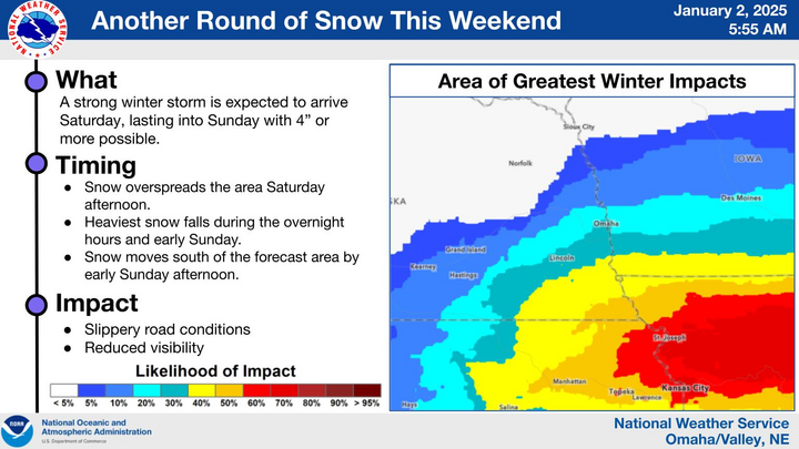
Winter Storm Potential
A sharp mid-level trough will be working its way into the Central Plains this weekend, temporarily slowing down on its journey from the Central Plains into the lower Midwest. A surface low will likely positioned a bit to the southeast of the upper-level low across the Oklahoma-Kansas border. This setup will allow strong moisture return well to the north and northwest of the main storm system on Saturday night into Sunday. Translation: Get ready for snow across most of the state.
An area of mid-level deformation will allow for a round of light snow on Saturday morning from central South Dakota into western Iowa, with an inch possible from O'Neill over to Macy. Isolated places may receive more but this looks to be nothing more than a nuisance at this point. The main event starts Saturday as the main storm system moves into the Central Plains. Snow will be likely in much of western Nebraska on Saturday night with accumulations of 1-2" likely, with 3" possible south of I-80 in the western section of the state. Lesser amounts likely in the northern Panhandle and the north central section of the state, where snowfall deficits and drought are most acute.
Snow should begin in south central and southeastern Nebraska a bit later on Saturday night and then should spread up to the I-80 corridor by morning. Snow is likely to fall for several hours across the south central, southeastern, and east central sections of Nebraska on Sunday. Snow may be heavy at times in southeast Nebraska as well, with 1"/hr snow rates possible from Lincoln to Nebraska City down to Beatrice and Falls City on Sunday morning. The technical definition of a blizzard is not likely to be met but there will be a decent breeze from the east-northeast, so travel may be hazardous. It also will be quite cold- mid teens during the snowfall. All areas of the state and region are running well below average on season-to-date snow and here in Lincoln, we have obliterated our record of most consecutive days without snow. So use extreme caution if driving on Sunday in areas where snow is falling since we haven't had much practice on it lately. Snow should taper off from northwest to southeast on Sunday afternoon and evening. Winds should also back off a bit on Sunday night. That should help with snow removal efforts before the Monday morning commute.
Models appear to be coming in line on storm track and totals. Both the GFS and ECMWF show a good chance of 6" plus across southeastern Nebraska and a broader area of south central and eastern Nebraska likely to get 3". The far southeastern corner has a shot at getting the whole foot, though that is certainly not the most likely outcome. There likely will be a relatively sharp cutoff in snow on Sunday between Highway 30 and Highway 20, with areas along and north of Highway 20 likely seeing an inch or less. There also is a chance precipitation could start as sleet or freezing rain across the Highway 136 corridor between Hebron and Falls City. Heavier ice accumulations are more likely in Kansas and Missouri (before they get snow) but a slightly more northward track will put the southern 50 miles of the state into the ice risk and push the heaviest snow axis up to the I-80 corridor. Recommend paying close attention to the forecast in the next two days.
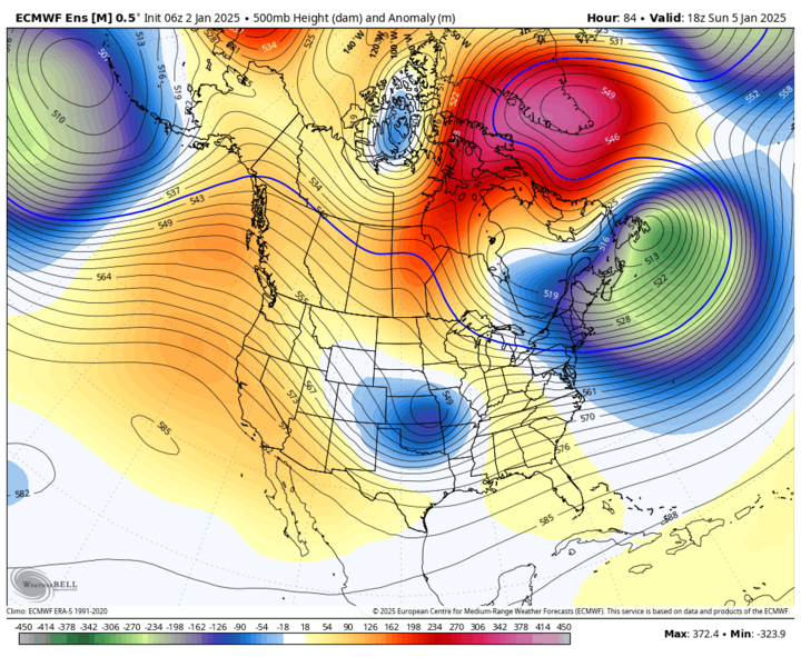
Cold week ahead
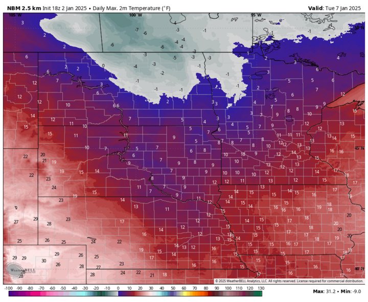
The atmosphere will be giving us a near Omega-block early next week with strong ridging over the western section of the continent, a sharp trough in the central and eastern sections, and ridging over Greenland. Translation: All aboard the Polar Express from the Arctic to the Northern Plains and Western Corn Belt! This will thankfully be a more seasonal outbreak of cold air across the state than last year around this time (i.e., not looking at highs of 5 to 10 below).
Nevertheless, this will be a multi-day stretch of temperatures staying well below freezing for the entire state. While no one will see subzero high temperatures, subzero temperatures are likely overnight the first half of next week across most of the state. Wind chills will be quite cold during this period too, with 15-20 below wind chills being common in eastern Nebraska on Monday and Wednesday mornings.
Temperatures should creep back into the 30's in western Nebraska on Friday and will probably get to 50 in far southwest Nebraska on Saturday as upper level ridging temporarily moves in from the west. The eastern side of the state is likely to stay locked in the deep freeze all next week and likely into the following week as well. Central Nebraska will see moderation than eastern Nebraska but not the same degree of warmth as the Panhandle and Southwest.
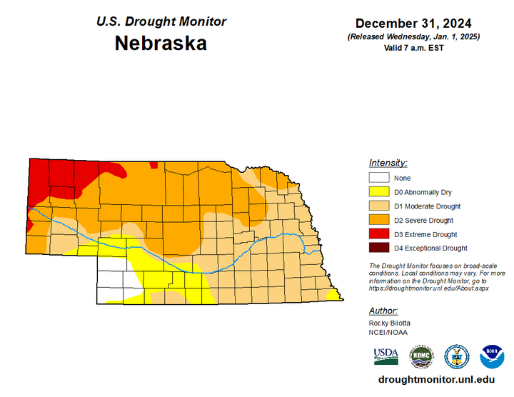
Drought update
Been a few weeks since I posted an update, so I did want to talk briefly about the U.S. Drought Monitor. Over the past few weeks, we have seen an expansion of severe drought (D2) into Kimball County, degradation in other areas of the southern Panhandle and southwestern Nebraska, and an expansion of extreme drought (D3) into more of Sheridan and Cherry County. These areas have a combination of significant short-term dryness, a prolonged abnormally warm signal, a complete lack of snow so far this season (more important in those areas), and some long-term dryness issues. Soil moisture percentiles remain below the 20th percentile in those areas and are below the 50th percentile statewide. Precipitation earlier this week across the eastern half of Nebraska and around Chadron in did help improve soil moisture a bit, since the ground was thawed after the unseasonably mild temperatures we had been having.