Severe weather and snow
The SPC has upgraded much of east central Nebraska to an Enhanced Risk for severe storms late this afternoon and this evening. Large hail remains the largest risk but tornadoes can't be ruled out. This is not likely to be a widespread outbreak or a prolonged event. Storms are likely to form along the cold front around 6:00 and move quickly to the east-northeast. How far southeast the front makes it will determine who gets the storms. Most indications right now are that the storms will initiate around Columbus and then head over toward Blair and Tekamah before paying Iowa a visit. It is possible David City, Seward, Lincoln, and Omaha could get a round of storms between 8:00 and 10:00 this evening. Suspect much of southeast Nebraska will remain dry tonight.
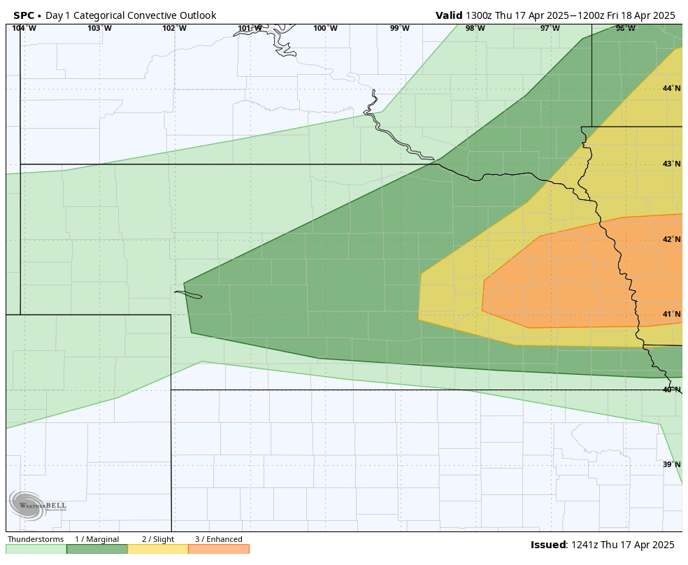
Figure 1. SPC severe storms outlook
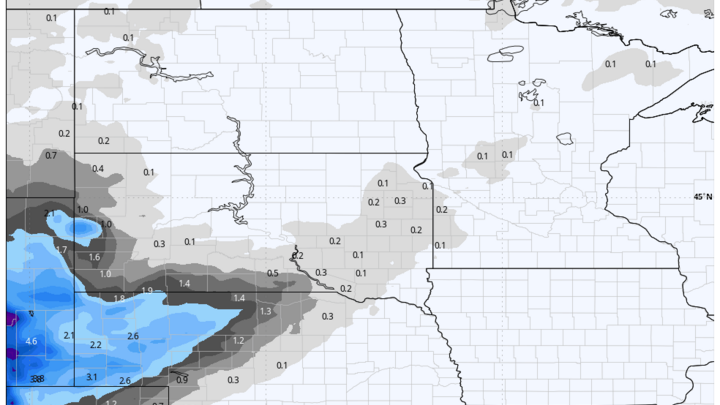
Out in the Panhandle, rain showers will become more likely later this afternoon and change over to snow overnight. Snow accumulations over 3" will be possible between Scottsbluff and Chadron. Total moisture won't be that significant but a quarter to third of an inch is possible and certainly better than nothing. Snow should melt quickly tomorrow, though it certainly will be on the cool side with highs around 40 in the Panhandle. Also will be much cooler tomorrow across southwest, central, and eastern Nebraska with temperatures holding in the mid 40's to low 50's with a stiff breeze from the north. Temperatures rebound on Saturday, albeit to levels that are still below seasonal normals. Scattered showers will be possible tomorrow morning in northeast Nebraska and early Saturday in southwest Nebraska.
Wet Easter
An upper level low will move into the Central Plains on Easter morning, which should bring a good chance of rain to the eastern half of the state. Current indicators show rain moving into southeast and south central Nebraska Sunday morning and spreading to the north through the early afternoon hours.
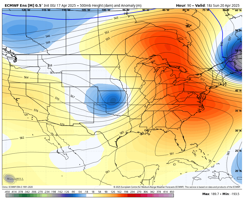
Figure 2. 500-mb height anomalies on Sunday
How much rain will fall is a bit uncertain but most signals points to it raining and being seasonally cool that afternoon in the eastern half of the state. An inch of moisture is rather likely in the southeast corner of the state and possible as far west as Grand Island and Albion. Much more significant moisture is likely to our southeast. Winds won't be super high on Sunday but there will be a breeze from the north-northwest.
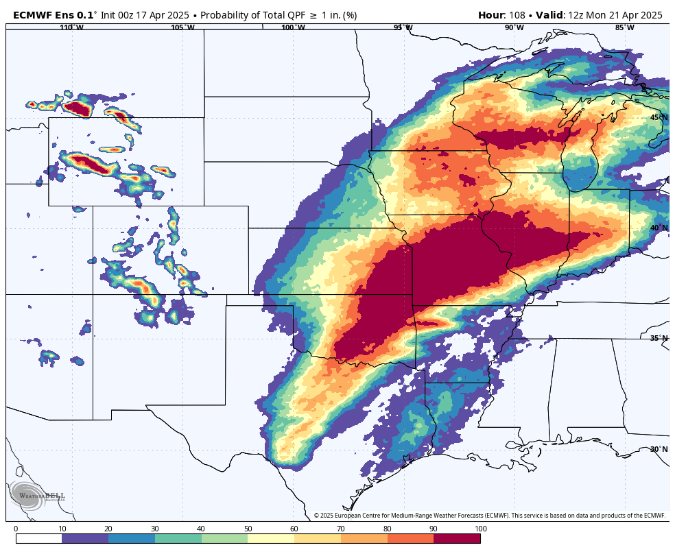
Figure 3. Probability of 1" of moisture through early Monday morning
Warmer temperatures return
Temperatures should rebound nicely on Monday as upper level ridging moves overhead with 70's likely statewide. A weaker cold front will move through the state on Tuesday, which will bring slightly cooler temperatures to the northwestern quadrant of the state. Highs elsewhere should be 75-80°F. Temperatures the remainder of the week look to remain a bit above seasonal normals in the upper 60's to mid 70's. Temperatures are likely to remain mostly above average into early May.
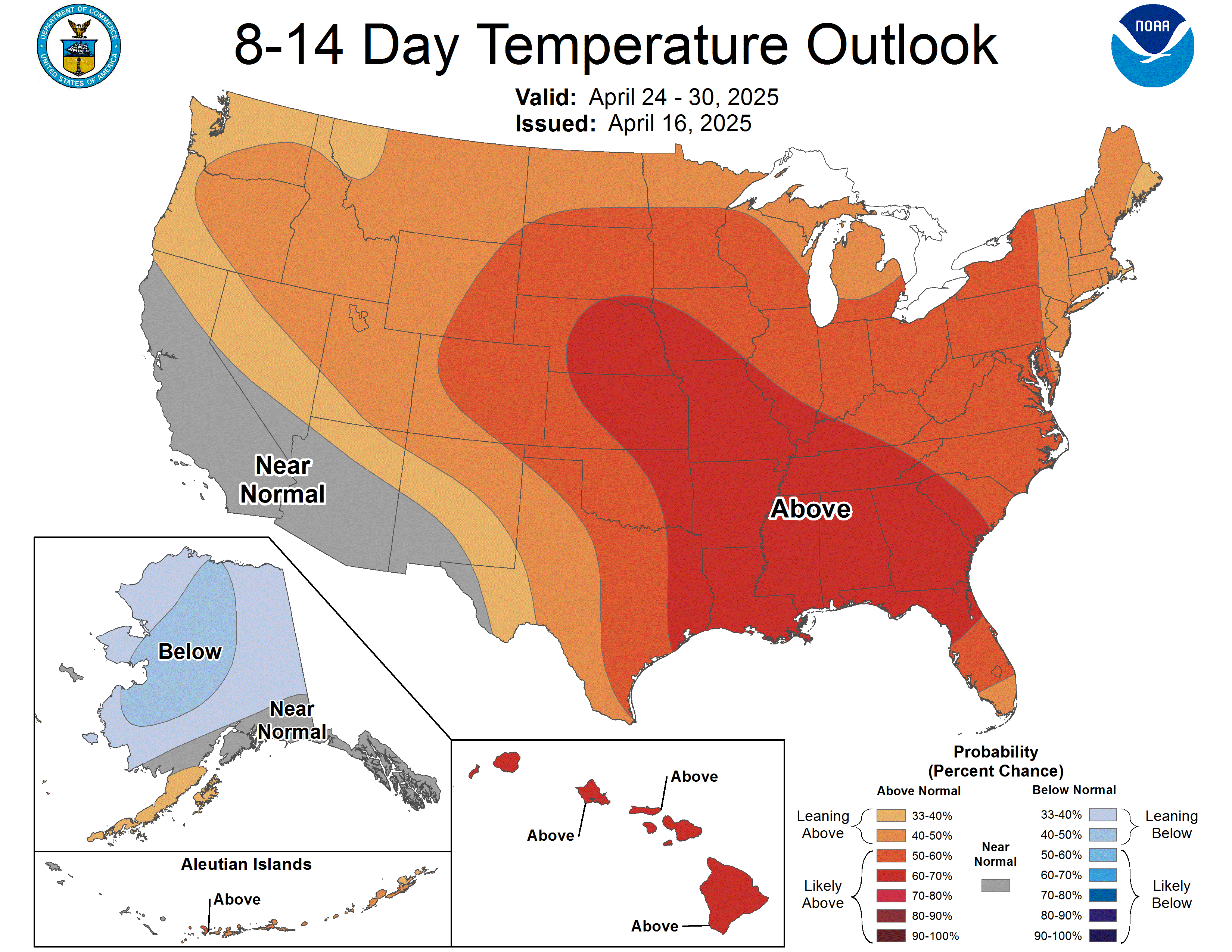
Figure 4. CPC's 8-14 day temperature outlook
Stormy end of week?
It does appear that most of the state will remain dry between Monday and Thursday morning, with the exception of a chance of showers in north central and eastern Nebraska on Tuesday afternoon with the cold frontal passage. Severe storms do not appear likely at the moment but will be worth watching as time gets closer.
Troughing is expected to be prominent off the west coast by the later portion of next week and may remain a prominent feature in southwestern U.S. through the first part of May. That would lead to southwest upper level flow, which combined with ridging to the east is favorable for the central U.S. to get moisture. This will lead to chances for showers and storms starting Thursday and it appears that there will be chances on a regular basis through the first few days of May. Evidence of this wet signal comes from the 8-14 day CPC outlook, which shows wetter than average favored for a large section of the U.S.
Additional evidence comes from the latest ECMWF weeklies, which shows precipitation being above average during the last part of the month. Severe weather risk will also be present, though it is too early to pinpoint exact times and types.
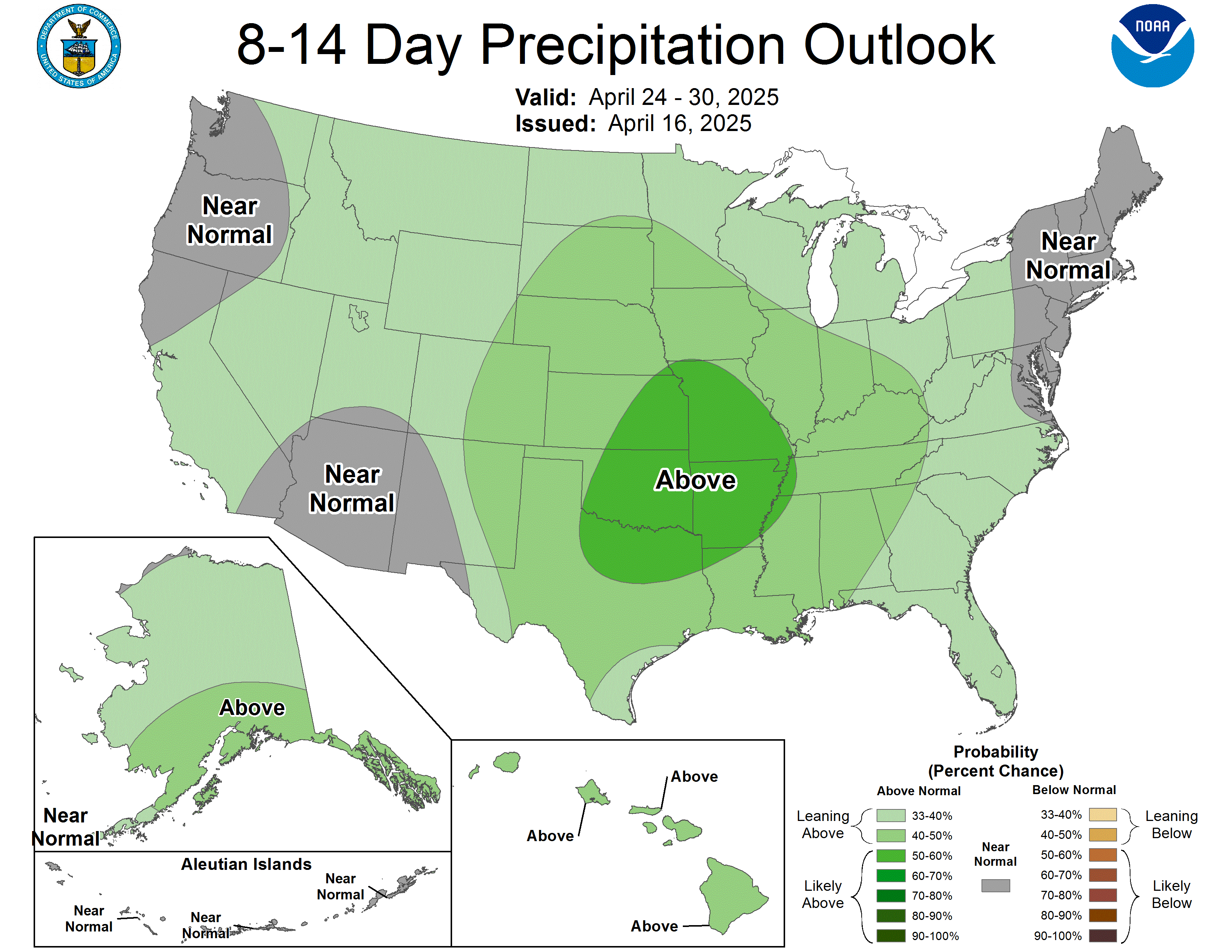
Figure 5. CPC's 8-14 day precipitation outlook
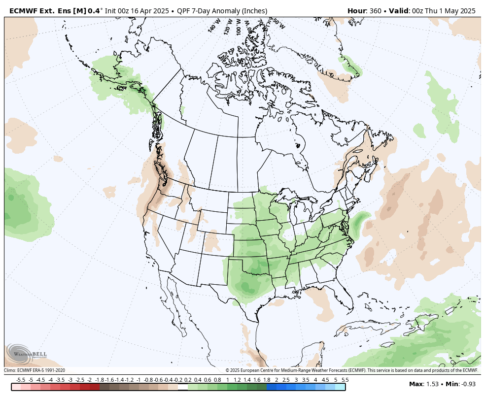
Figure 6. ECMWF weeklies for precipitation anomalies
Drought update
This moisture would be very welcome across the state and the broader Western Corn Belt and Great Plains region. It has been a very dry month so far across this area of the country with only pockets of the state receiving above average month to date precipitation. Driest spots run from Clay Center up through York and Stromsburg.

Figure 7. Percent of average precipitation so far in April
The lack of moisture since the blizzard and lower streamflow percentiles led to a broad 1-category decline on the U.S. Drought Monitor across the south central and eastern section of the state. The percent of state in drought shot from 75 to 90 percent from last week to this week.
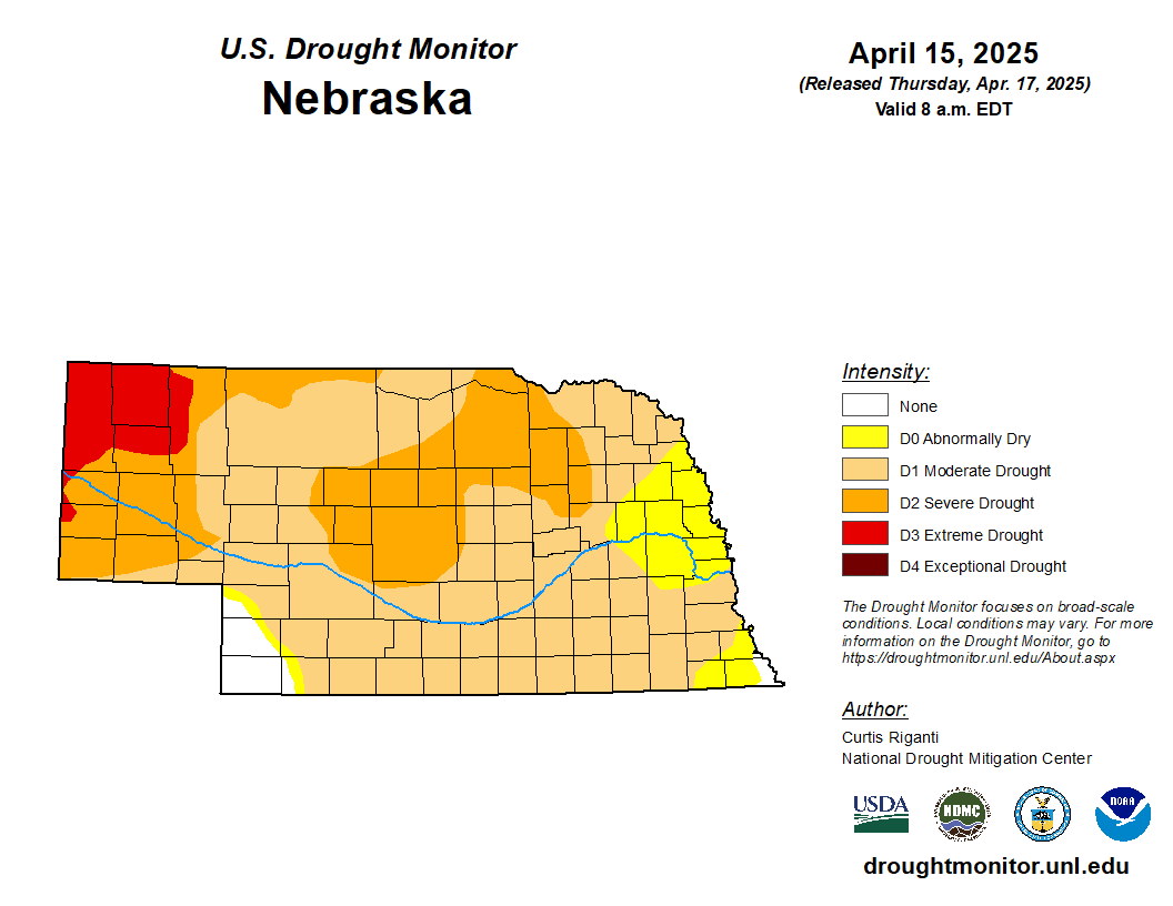
Figure 8. Latest U.S. Drought Monitor


