Shorter, Warmer Winters
Across Nebraska, warmer winter temperatures are increasingly likely. Freezing temperatures throughout the state are less stagnant due to more frequent, persistent warm spells. Snow cover is less persistent, and winter precipitation appears to be increasingly tied to rare, extreme events. How are these changes different from historical trends? How will these changes impact Nebraskans for winters to come?
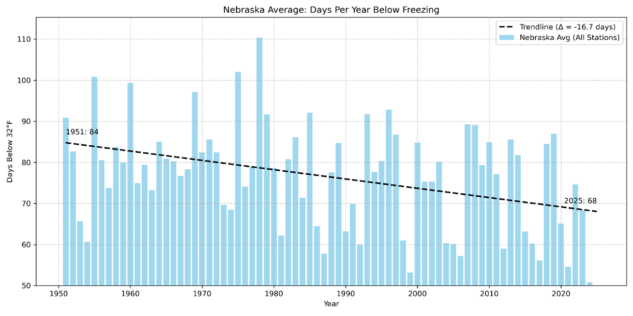
Figure 2: Freezing days per winter across Nebraska. Dates are limited from November to March, focusing on typical winter weather months. Averaged over 9 stations across Nebraska. Annually, 16 fewer days are below freezing in Nebraska. Extensively cold years, like 1979, have been far less common since the turn of the century.
A strong place to start is to consider how many days, per winter, are below freezing. In Nebraska, the average city has lost over two weeks of annual freezing days. This is significant, and reflects the ever-increasing presence of dormancy breaks, which will be further discussed below. It also shines a light on how Nebraska winters are starting later each year. Lakes and rivers freeze later, and organic life enters dormancy periods later. Historic averages have the first freeze in Nebraska on December 3; more recently, this same freeze occurs two days later.
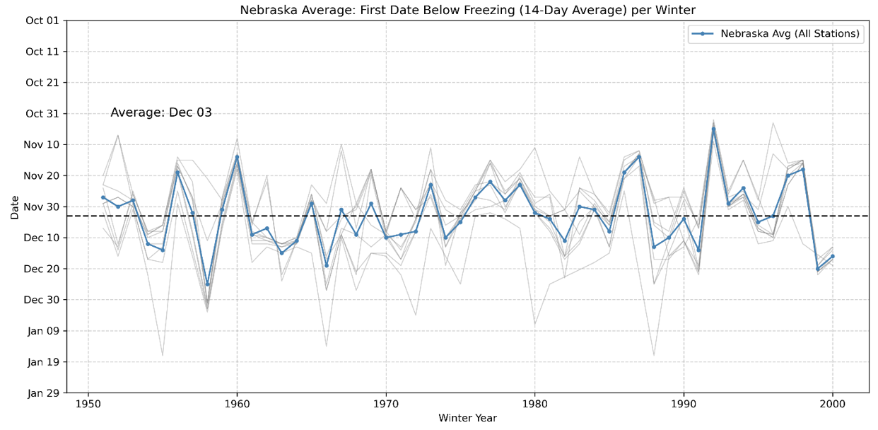
Figure 3: First day where the previous 14-day temperature average was below freezing, from 1951-2000. Averaged over 9 stations across Nebraska. The average freezing date across this range is December 3rd.

Figure 4: First day where the previous 14-day temperature average was below freezing from 2001-2025. The average freezing date across this range is December 5th, 2 days later than the previous timeframe.
Periodic Extreme Cold?
It could be easy to point out that while our winters are certainly shorter, they may be more extreme. This appears to be the case in cities in far western Nebraska, where extreme cold spells are becoming colder. The annual coldest day in Scottsbluff now has an average temperature of -6.0 degrees Fahrenheit, which is several degrees colder than the climatological average.
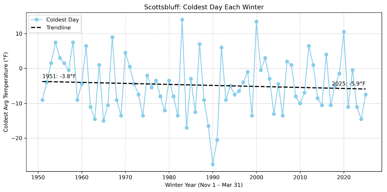
Figure 5: Coldest average day temperature each winter, from 1951 to 2025, in Scottsbluff, Nebraska. Average coldest day decreased by about 2.1 degrees Fahrenheit.
This trend, though, does not reflect the state as a whole. Averaging out the coldest day provides a clearer picture. The vast majority of Nebraskan cities are seeing less extreme cold spells. The coldest days are warmer each year by about 2 degrees.
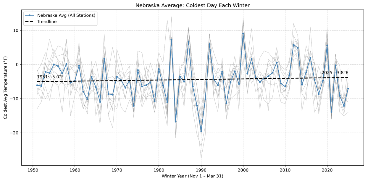
Figure 6: Coldest average day temperature each winter, from 1951 to 2025 across Nebraska. Average coldest day has increased by about 2.2 degrees Fahrenheit.
Why – Arctic Air?
While the mechanics behind these changes will not be discussed at length, it is critical to understand why these changes are happening. They reflect a wider, global trend where polar air patterns are more erratic. This behavior of the arctic air is called the polar vortex. As it becomes more irregular, larger cool air masses are drawn South through Canada and the United States. This pushes warm air masses to the space left behind, creating stark ridges where strong winds and precipitation are more common. For winter weather, this is a primary driver of Nebraska’s warming winters due to climate change.
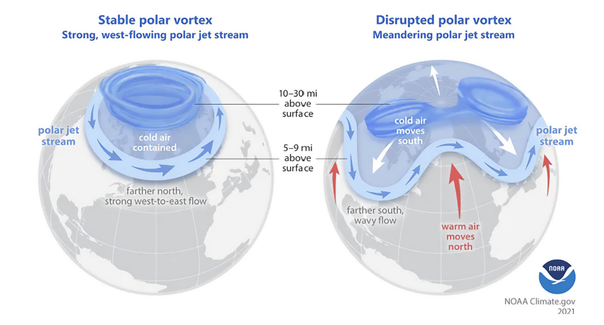
Figure 7: When the Arctic warms, the jet stream weakens and becomes more wavy, allowing cold Arctic air to move to the south and warm tropical air to move to the north. (Source: Lindsey, 2021)
Snow Cover – Deeper, Less Frequent
Keeping in mind how global change is causing more frequent disruptions to the polar vortex, a key aspect of winter to investigate is precipitation. Days with snow cover are decreasing across the state. This is likely from a combination of warming winters, causing quicker melting, as well as drier winter climate.
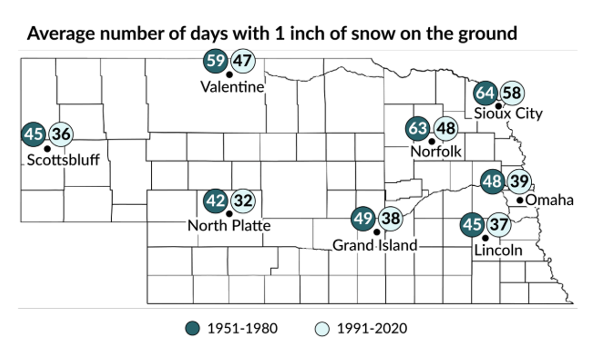
Figure 8: Historical snow cover differences across the state, obtained from Nebraska Climate Assessment. Visualizes the average number of days in a year with one inch or more of snow cover from 1961 to 1980 (darker circles) compared to 1991 to 2020 (light circles).
Snow cover is important because it protects soil and perennial crops from harsh winter freezes. By acting like a blanket, it insulates soil and cover crops from more extreme air temperatures. It also prevents excessive wind erosion, during months where topsoil is loose without active organic matter.
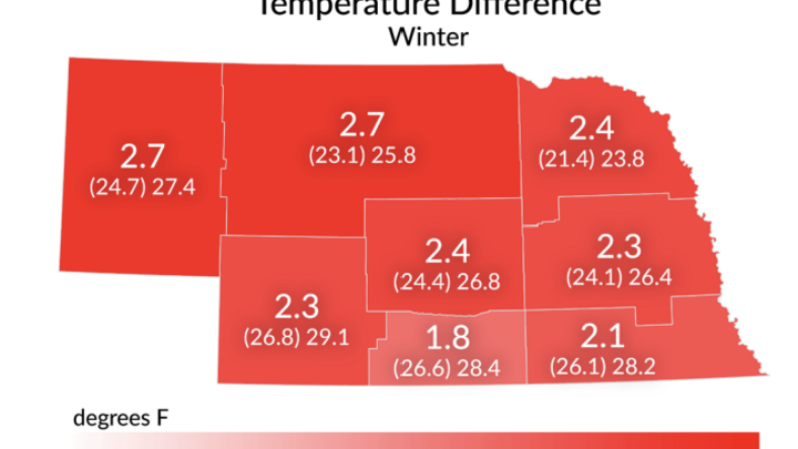
Similarly, winter precipitation is essential for spring-time agricultural operations. Below average precipitation during winter months delays planting, especially for water-intensive crops, and puts strain on irrigation systems. Historical trends visualize how these snow issues are most relevant across western counties. Cities like Scottsbluff will see the largest future impacts.
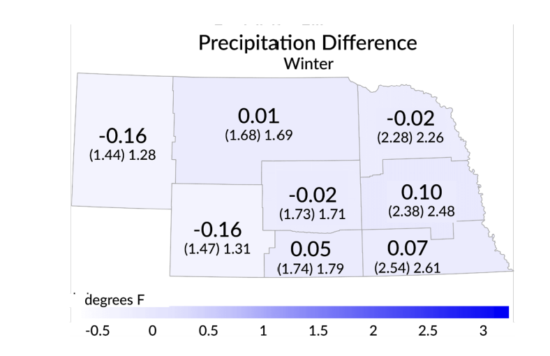
Figure 9: Changes in winter precipitation, obtained from Nebraska Climate Assessment. Difference is from 1994 to 2023 compared to 1895 to 1960. The number in parentheses in row 2 represents the average precipitation from 1865 to 1965, and the number outside of the parentheses represents the temperature from 1994 to 2023.
Fire danger is also an essential consideration. Lower precipitation, combined with a lack of persistent snow cover, expands the climatological days with high fire risks. The annual number of days with dry, dead biomass and warm, windy weather is only exacerbated when considering the shorter winter seasons.
Implications – Dormancy Breaks
It can be difficult to understand how these may affect an individual Nebraskan’s future. For many in agriculture, longer and more frequent dormancy breaks are a primary concern. Dormancy breaks, or consecutive days above freezing, are greatly damaging for perennial crops. Seedlings and crops can sprout early, which often stunts or prevents growth when a winter freeze arrives shortly after.
In Nebraska, this is most relevant for alfalfa farmers. These grasses are utilized as a feed crop for cattle but are one of the most widespread crops that is harmed by dormancy breaks. More frequent, longer warm spells will require future adaptations, such as selecting better adapted alfalfa varieties.
https://cropwatch.unl.edu/pasture-and-forage-minute-snow-cover-concerns-selecting-alfalfa-varieties/
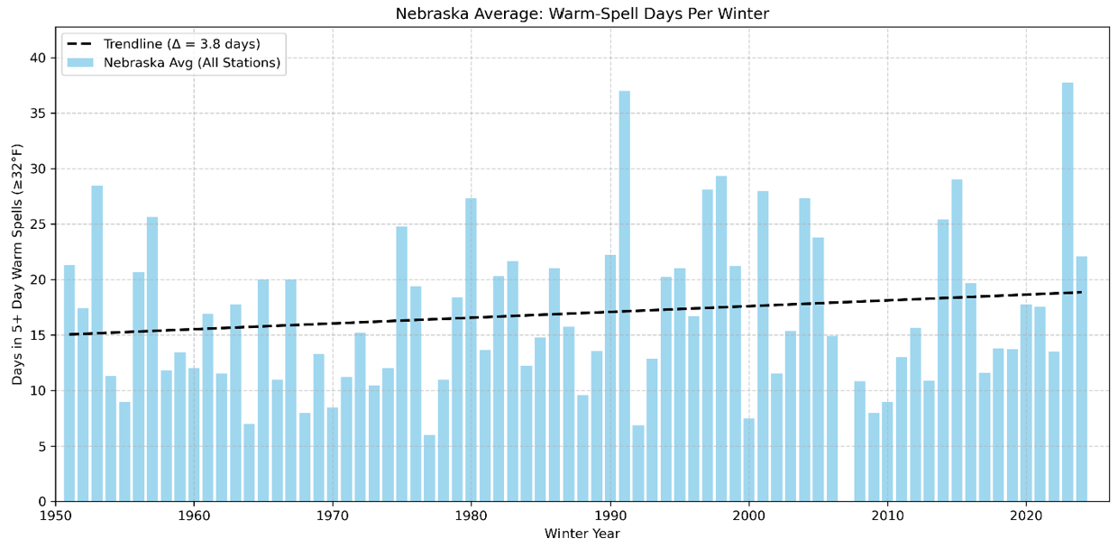
Figure 10: Average number of days spent in warm spells (5+ consecutive days ≥32°F) per winter, from 1951–2025. Averaged over 9 stations across Nebraska. The trendline shows an increase of 3.8 days over the period.
Preparing for a Warmer Future
Nebraska winters are unequivocally warming. It can be difficult to understand why this impacts Nebraskans, besides those who actively enjoy shoveling snow in record cold. These climatological variations, however, have applicable, real-world implications.
For farmers, these shorter winters increase their risks for erosion, fire danger, and perennial crop damage. Ecological considerations include ecosystem processes that require typical seasonality swings, like mammal hibernation or pest prevention.
Recognizing these fluctuations, and the wider climate trends they reflect, allows us to take steps to prevent and mitigate future issues. Only in doing so can Nebraskans continue to thrive in our warming world.


