Hello NSCO community! As we approach the end of 2025, I would like to explore an unusual month for the state this past November. This month, Nebraska transitioned from quiet and mild conditions, with warm temperatures, to a mid-month warm surge with fire-weather concerns, and then to a much more active, colder, and windier pattern late in the month.
November began with Nebraska situated between a ridge to the southwest and a trough to the north, keeping things mostly dry and comfortably mild, with highs commonly in the 60s and even the upper 60s to low 70s at times, before a cold front cooled things back down toward the mid-part of the month.
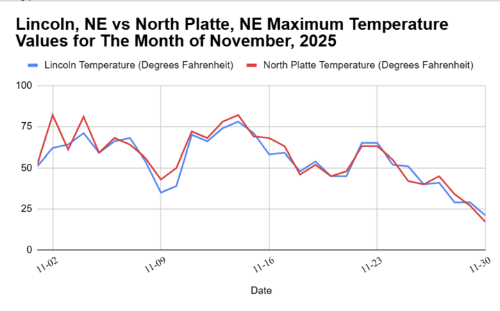
By the second week (November 10–13), a cold start with temperatures in the 10s and 20s gave way to a rapid warmup, with highs reaching the 60s and low 70s. This, paired with dry air and low relative humidity, elevated fire danger, especially in northeast Nebraska. By mid-month (Nov 17–18), there was more unstable air that produced precipitation, and even isolated thunder, with a return to mild/dry weather toward early Thanksgiving around the 24th-25th . This is illustrated below with a graph showing the average temperatures for the state of Nebraska. Based on 133 years of climatological data, our temperatures have been on a generally warmer trend, with the highest readings occurring in central Nebraska. I also went ahead, and created a graph showcasing the past month's highest recorded temperatures for North Platte, which is on the western side of the state, compared to Lincoln, which is more on the east side. Both temperature values showcase highs reaching the low 80s for early November in North Platte (in the red), and the upper 70s for Lincoln (in blue).
Later in the month (November 24–25) we had lingering drizzle/fog conditions, followed by a high-impact wind event and early winter travel issues heading into the holiday weekend after Thanksgiving day. At 500 mb early in the month, Nebraska was often in zonal to northwest flow on the edge of a ridge-trough couplet, enough to keep the storm track mostly displaced and moisture limited. Mid-level ridge building east and lee troughing deepened into a surface low that supported a strong low-level southerly component and a jump to upper-60s to mid-70s by Friday the 14th timeframe (warmest day called out as Friday with near-record potential). So you got lots of “clouds aloft, and “dry at the surface” type setups in the beginning and middle of the month.
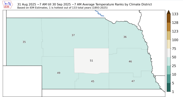
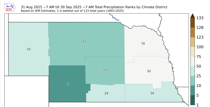
By November 17–18, the pattern transitioned toward more active troughing/closed-low influences, which is when rain chances increased (especially south of I-80 in some guidance) before ridging briefly returned. Then, later in the month, the discussion pivots sharply towards a northwesterly flow and cold air advection behind a strong system, setting the stage for both the wind event and increased late-month snow potential. Of course, by the latter half of November, we experienced more disturbances in that flow aloft that allowed convection to occur and bring us that precipitation. This is illustrated below using a similar scale of 133 years of climatological data. We experienced extremely wet conditions in southwestern Nebraska; however, areas of northeastern Nebraska had drier conditions.
The impact of frontal timing was most pronounced in early November, when cold fronts moved through with minimal moisture. The mid-month warm spell was accompanied by dry air and periods of low relative humidity, resulting in high to very high fire danger callouts in northeast Nebraska as warm sector air surged in ahead of the next front.
Specifically, on the date of November 17, we experienced a more classic setup with a warm front / low pressure, which brought showers, and even isolated thunderstorms along the boundary near the Missouri River north of Omaha, with a cold front overnight that brought a wind shift and seasonably cooler air later into the month.
There were also some featured fog/drizzle near and east of the Missouri River, with a strong cold front and deep mixing behind it, driving the big wind day and ushering in colder air. Overall, precipitation opportunities were limited early in the month, with multiple days experiencing mid-level lift. The more meaningful precipitation windows showed up November 17–18 (showers, a few storms; some places even saw hail per discussion) and then again around November 24–25 with drizzle/light rain before the wind and cold surge. At the end of the month, we experienced some snow bands and wintry impacts in parts of southeast Nebraska after Thanksgiving, especially on Friday into Friday night, although the exact placement/amounts were still a moving target in the discussions.
Some big extremes we experienced in the state:
Warmth peak: mid-month warm surge with highs in the upper 60s to mid 70s, near record territory in eastern Nebraska.
Cold shot: early-month mornings in the teens and 20s before the warmup.
Wind extreme: late-month event with gusts 35–50 mph widely, and 50–60 mph observed concern in northeast Nebraska.
Precipitation highlight: showers/thunder mid-month, drizzle late-month, with small trace amounts of snow for central to eastern Nebraska after Thanksgiving.
To summarize, this past month, November 2025 started with a lot of dry, ridge-influenced variability, ramped into a big mid-month warm spell with fire-weather signals, then ended with a sharp pattern change with fog/drizzle, a major wind day, and a much colder regime with snow chances increasing into the post-Thanksgiving period.