Summary
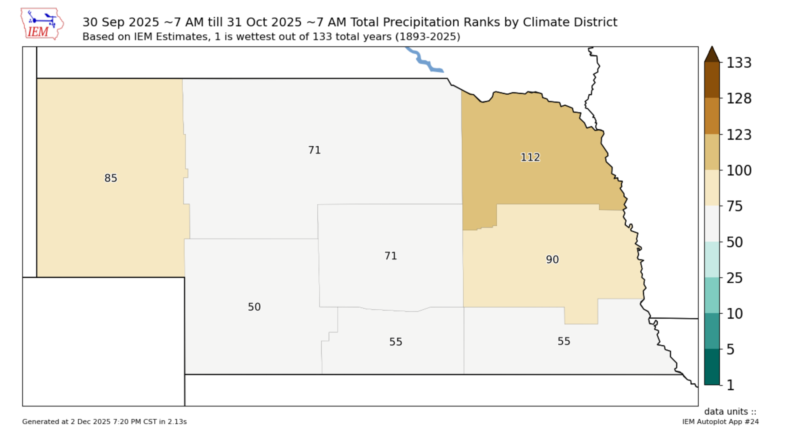
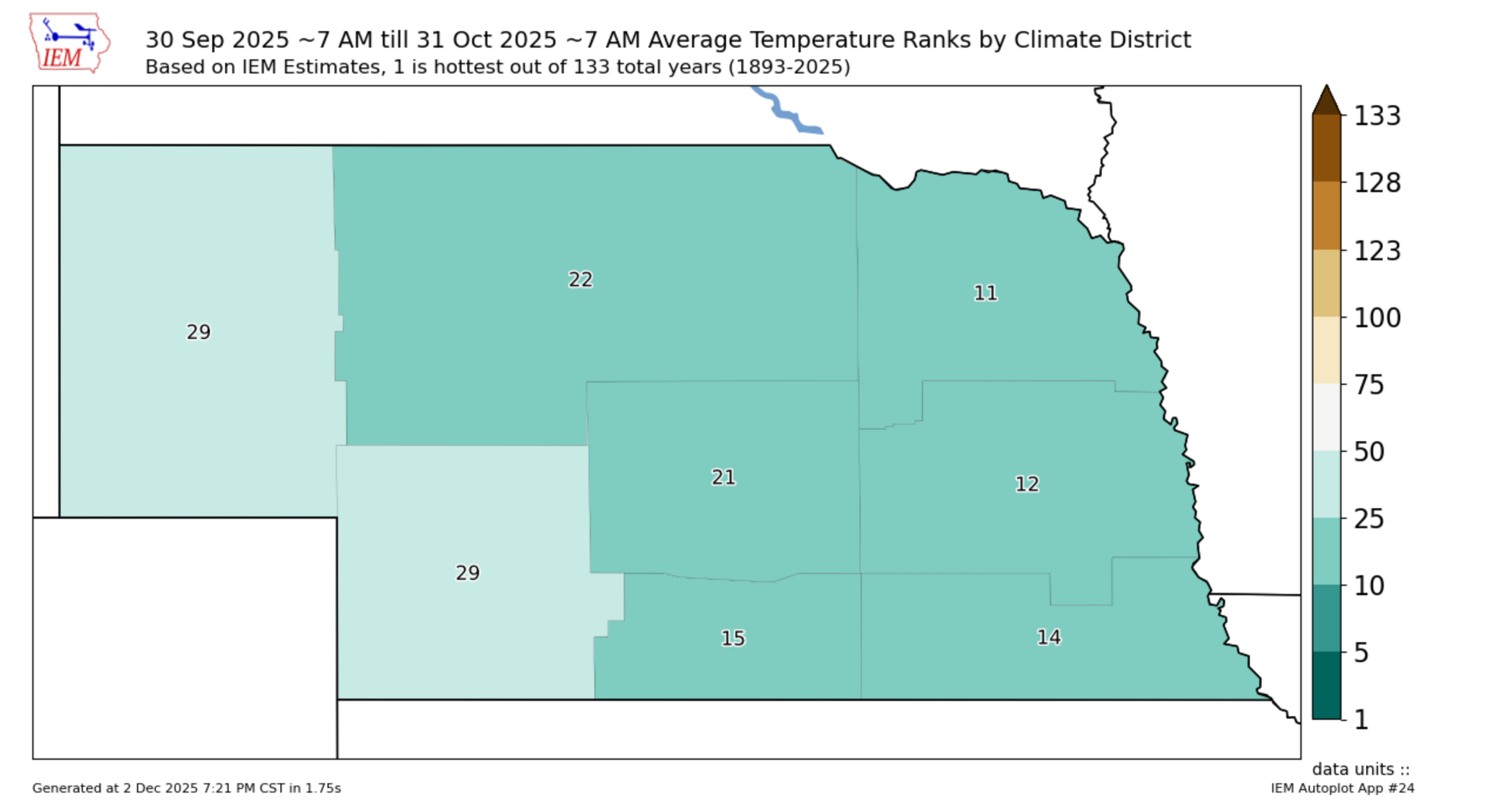
The NCEI put the statewide average temperature for Nebraska in October 2025 at 55.3°F, which was 4.5°F above average and ranked as the 9th warmest October on record. All climate divisions above average, with the largest deviations in eastern Nebraska. Looking at the NOAA NCEI U.S Climate Normals, the statewide average precipitation was 1.08 inches, which is 0.34 inches below the 20th-century average precipitation. Southeast Nebraska had above average precipitation but the other seven climate divisions were below average, with Northeast Nebraska having the biggest deficit (-0.87"). For the U.S. overall, October 2025 was the 8th warmest and 44th wettest.
Temperatures, Humidity & Precipitation Trends
October 2025 began with very warm conditions across the state with near-record temperatures in the upper 80's to lower 90's. Seasonably cool conditions returned briefly, with parts of southeast Nebraska getting significant moisture. The middle of the month brought repeated warmups into the 60s, 70s, and even low 80s, especially across central and southern Nebraska, as southerly flow returned and ridging built overhead. Humidity fluctuated considerably higher early and mid-month when low stratus, fog, and scattered showers were present, then fell sharply behind several cold frontal passages, especially during Oct 20–22 when RH dropped to 25–35%, aiding elevated fire danger during harvest operations. The final week turned decisively colder, with highs only in the upper 40s to 50s and widespread fog, frost, and subfreezing lows following a strong cold front that brought a broad swath of 0.25–0.75" rainfall to eastern Nebraska October 27–29. Below, I would like to include two graphics representing the October drought monitor, as well as the mean temperature trends for the month of October, which can help us better grasp the information stated above.
Upper Air Pattern Tie-Ins
Weak ridging at both 850 mb and 500 mb supported several warm periods, such as the mid-month surge into the 70s and 80s, when strong southerly low-level flow advected warm, dry air northward into Nebraska. Throughout the month, multiple western U.S. troughs dug into the central Plains, each reinforcing cold-air intrusions. Mid-month featured a deeper Pacific-side trough, with a jet streak aloft facilitating weak elevated convection and light rainfall. Later in the month, a closed 500-mb low near the southern Plains lifted northeast, enhancing upper-level divergence and widespread precipitation on October 27–28. Meanwhile, strong 850-mb northwesterly winds (40–50 kt) behind the front supported widespread surface wind gusts of 30–40 mph and sharp temperature drops.
Fronts & Localized Impacts
October saw several impactful frontal passages across the state. A stationary front early in the month led to cool, cloudy, and drizzly weather in the southeast before shifting southeastward on Oct 6–7, allowing skies to clear and cooler air to settle in. A warm front mid-month lifted through southern Nebraska, producing fog and low stratus north of it and light rain/drizzle along its northern edge. Multiple cold fronts followed, including a powerful surge from Oct 20 to 22 that produced 35–45 mph wind gusts and a sharp drop in humidity, elevating fire danger across eastern Nebraska. The strongest front of the month arrived on Oct 27–28, producing widespread rainfall, strong northwest winds, and widespread MVFR/IFR conditions, with extended fog and freezing fog impacts later in the week.
Precipitation Recap
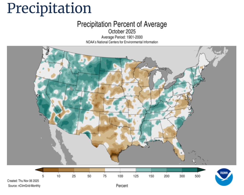
Monthly precipitation was highly variable, with most locations accumulating between 0.25 and 1 inch, although the largest single-event totals occurred on October 27–29. Early-month precipitation was light and patchy, mostly limited to drizzle and light showers south of I-80 during the Oct 6–7 event. Mid-month precipitation was sparse, with most locations picking up only a few hundredths to a tenth of an inch from weak shortwaves and shallow moisture profiles. The most widespread rainfall arrived late month: 0.25–0.75" across much of the state, with ~1" totals near the Missouri River and into western Iowa, where the precipitation shield lingered longer. Some western and central counties saw less than 0.25" during the final event as dry air undercut the system from the west. The graph below represents the average precipitation for the past month. Notably for October, there was a noticeable dip in precip with much less being seen in the state, compared to other parts of the United States.
Extremes & Notable Events
Notable events included pea-to nickel-size hail early in the month with elevated convection near the Oct 6 frontal zone. Several mornings mid-month featured dense fog and low stratus north of warm fronts, with visibility dropping to near zero at times in northeastern Nebraska. The strongest winds of the month occurred on October 20–22 (gusts 35–45 mph), producing an elevated fire danger during harvest operations. The coldest period arrived from October 29 to 31, when lows fell into the upper 20s, marking the first widespread freeze across eastern Nebraska, accompanied by freezing fog and patchy black ice development on bridges.
Temperature and Precipitation Roundup:
- Maximum High: 94°F, Verdel 6 SSE
- Minimum High: 41°F, Bushnell 15 S
- Minimum Low: 7°F, Harrison 20 SSE


