
Another wet week. Temperatures mostly above average
Most of the state saw additional rainfall last week, with areas along the Kansas border in south central and southeastern Nebraska receiving significant precipitation on the 21st. Most of the state saw precipitation Wednesday afternoon into Thursday morning, with some wind and hail damage around Kearney and in parts of northeast Nebraska. Additional rainfall fell in southeast Nebraska on Friday.
Temperatures were generally above average last week, especially at night. Many sites in eastern Nebraska remained over 70°F at night for several days in a row, even on Thursday and Friday when maximum temperatures were lower. Hottest temperatures for the week occurred in the Panhandle last Monday when multiple locations were over 100°F.
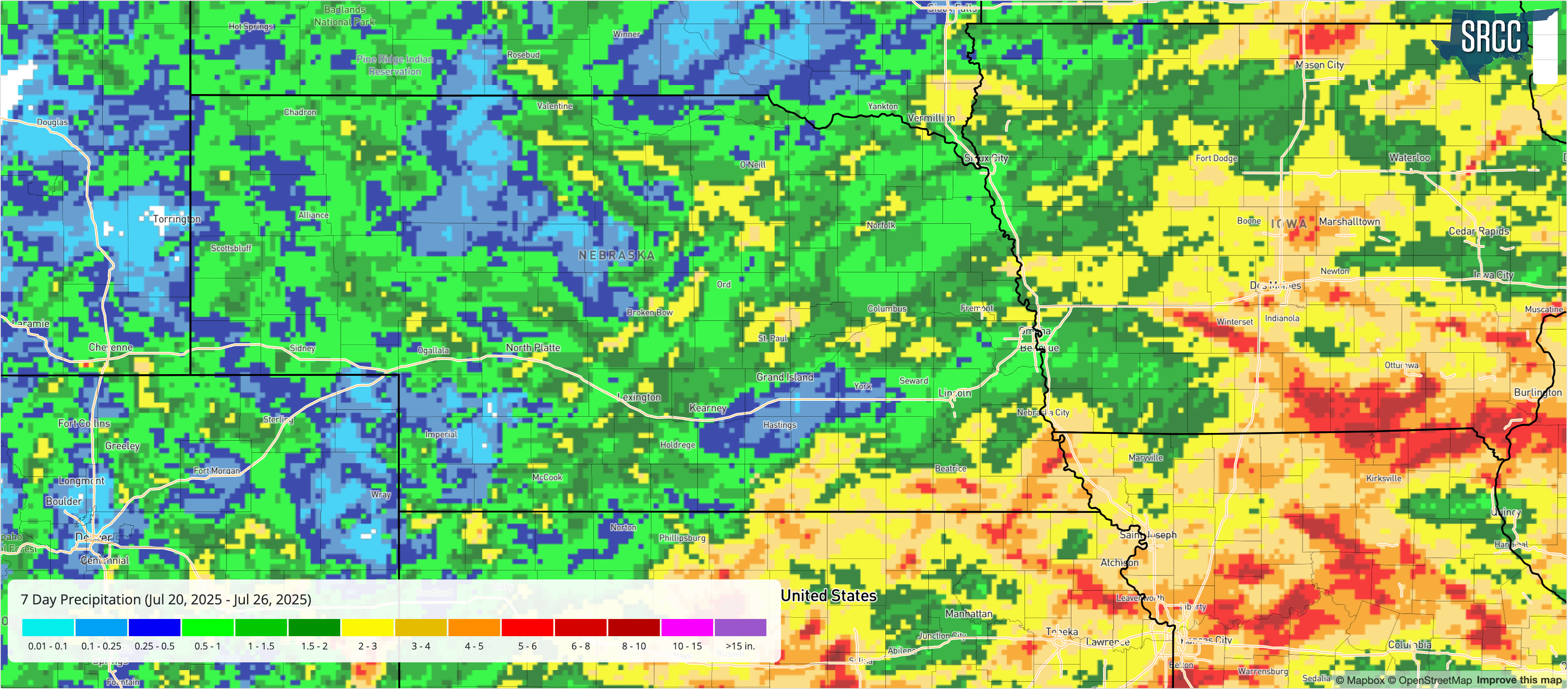
Figure 1. Total precipitation for the week ending July 26, 2025
The table below shows maximum temperature, minimum temperature, average temperature, the number of days with maximum temperatures ≥95°F, minimum temperatures ≥70°F, total precipitation, growing/heating/cooling degree days, and average daily potential ET for the Nebraska Mesonet stations. Here are the temperature and precipitation extremes from last week:
Maximum High Temperature: 104°F, Alliance Municipal Airport
Minimum High Temperature: 76°F, Elgin
Minimum Low Temperature: 49°F, Bushnell 15 S
Maximum Low Temperature: 75°F, Nebraska City 2 NW
Maximum Precipitation: 4.90", Pawnee City 8.1 SW
| station | MaxT | MinT | AvgT | >95F | >70F+ | Prcp | GDD | CDD | HDD | pET |
| Alda 5NW | 89 | 65 | 75.9 | 0 | 1 | 0.15 | 176 | 77 | 0 | 1.42 |
| Alliance 6NW | 100 | 52 | 75.7 | 4 | 0 | 1.03 | 156 | 75 | 0 | 2.56 |
| Arthur 8S | 94 | 59 | 75.2 | 0 | 0 | 0.44 | 163 | 71 | 0 | 2.23 |
| Axtell 5NE | 91 | 64 | 75.7 | 0 | 0 | 0.06 | 171 | 75 | 0 | 1.40 |
| Big Springs 6SE | 98 | 56 | 76.8 | 1 | 1 | 0.01 | 172 | 83 | 0 | 2.53 |
| Big Springs 8NE | 98 | 56 | 76.1 | 1 | 0 | 0.39 | 164 | 78 | 0 | 2.51 |
| Broadwater 7N | 99 | 54 | 76.1 | 3 | 0 | 0.00 | 155 | 78 | 0 | 2.69 |
| Bushnell 12SE | 94 | 54 | 73.8 | 0 | 0 | 0.11 | 152 | 61 | 0 | 2.59 |
| Central City 3W | 88 | 65 | 76.0 | 0 | 0 | 0.78 | 177 | 77 | 0 | 1.35 |
| Concord 2E | 87 | 66 | 75.6 | 0 | 1 | 0.57 | 175 | 74 | 0 | 1.24 |
| Cook 4SW | 90 | 69 | 77.8 | 0 | 5 | 1.09 | 187 | 90 | 0 | 1.16 |
| Decatur 7S | 89 | 69 | 77.4 | 0 | 3 | 1.94 | 188 | 87 | 0 | 1.27 |
| Dickens 1NE | 93 | 62 | 76.9 | 0 | 0 | 0.01 | 172 | 83 | 0 | 2.16 |
| Eagle 3NW Beta | 93 | 68 | 77.8 | 0 | 3 | 0.94 | 183 | 89 | 0 | 1.28 |
| Emmet 2E | 91 | 63 | 76.0 | 0 | 0 | 0.42 | 174 | 77 | 0 | 1.66 |
| Enders 10SW | 98 | 59 | 78.1 | 3 | 0 | 0.05 | 168 | 92 | 0 | 2.59 |
| Firth 3N | 90 | 68 | 76.4 | 0 | 2 | 2.65 | 178 | 80 | 0 | 1.11 |
| Fordyce 4N | 87 | 66 | 76.2 | 0 | 2 | 0.30 | 179 | 78 | 0 | 1.31 |
| Gothenburg 2NW | 91 | 64 | 76.8 | 0 | 1 | 0.68 | 178 | 83 | 0 | 1.75 |
| Guide Rock 3E | 92 | 66 | 77.8 | 0 | 3 | 0.98 | 183 | 89 | 0 | 1.56 |
| Harrisburg 1N | 99 | 52 | 77.2 | 2 | 4 | 0.93 | 169 | 85 | 0 | 2.79 |
| Harvard 4SW | 90 | 64 | 75.6 | 0 | 0 | 0.01 | 172 | 74 | 0 | 1.31 |
| Hayes Center 3N | 96 | 62 | 77.9 | 1 | 0 | 0.00 | 174 | 90 | 0 | 2.19 |
| Holdrege 5N | 92 | 63 | 75.9 | 0 | 0 | 0.07 | 172 | 77 | 0 | 1.57 |
| Indianola 8SW | 97 | 64 | 79.7 | 2 | 2 | 0.05 | 182 | 103 | 0 | 2.44 |
| Kearney 3E | 91 | 65 | 75.9 | 0 | 0 | 0.08 | 170 | 76 | 0 | 1.51 |
| Keystone 4W | 97 | 61 | 76.9 | 1 | 0 | 0.80 | 170 | 84 | 0 | 2.46 |
| Leigh 1W | 88 | 66 | 75.8 | 0 | 0 | 0.72 | 176 | 75 | 0 | 1.25 |
| Lexington 4S | 89 | 65 | 75.8 | 0 | 1 | 1.03 | 173 | 76 | 0 | 1.49 |
| Lincoln 1500 N 45th | 93 | 69 | 79.0 | 0 | 6 | 0.90 | 190 | 98 | 0 | 1.25 |
| Long Pine 20S | 90 | 64 | 75.3 | 0 | 0 | 0.59 | 171 | 72 | 0 | 1.78 |
| Memphis 4N | 91 | 68 | 77.8 | 0 | 4 | 0.76 | 185 | 89 | 0 | 1.26 |
| Memphis 5N | 91 | 68 | 77.8 | 0 | 4 | 0.82 | 186 | 89 | 0 | 1.25 |
| Merna 2SW | 90 | 64 | 75.5 | 0 | 1 | 1.01 | 171 | 74 | 0 | 1.45 |
| Naper 12SW | 92 | 64 | 75.8 | 0 | 1 | 0.00 | 173 | 76 | 0 | 1.94 |
| Nebraska City 3W | 90 | 69 | 78.1 | 0 | 6 | 1.15 | 191 | 92 | 0 | 1.16 |
| North Platte 3SW Beta | 94 | 63 | 77.6 | 0 | 1 | 0.59 | 177 | 88 | 0 | 1.90 |
| Oakland 4W | 89 | 67 | 76.3 | 0 | 0 | 2.49 | 181 | 79 | 0 | 1.13 |
| Ord 2N | 89 | 64 | 75.6 | 0 | 1 | 0.46 | 173 | 74 | 0 | 1.54 |
| Oshkosh 6N | 95 | 55 | 75.3 | 2 | 0 | 0.85 | 159 | 72 | 0 | 2.65 |
| Overton 6SE | 89 | 64 | 75.4 | 0 | 0 | 0.86 | 171 | 73 | 0 | 1.42 |
| Pierce 2SW | 87 | 66 | 75.8 | 0 | 0 | 1.14 | 177 | 76 | 0 | 1.39 |
| Plattsmouth 2SE | 90 | 68 | 77.5 | 0 | 6 | 1.56 | 185 | 87 | 0 | 1.18 |
| Rulo 5SW | 90 | 70 | 78.1 | 0 | 5 | 2.87 | 187 | 91 | 0 | 1.10 |
| Scottsbluff 2NW | 97 | 55 | 76.8 | 3 | 0 | 0.69 | 161 | 83 | 0 | 2.21 |
| Scottsbluff 6NW | 95 | 55 | 75.5 | 1 | 0 | 0.79 | 158 | 74 | 0 | 2.10 |
| Shelton 2SW | 89 | 64 | 75.0 | 0 | 0 | 0.27 | 168 | 70 | 0 | 1.31 |
| Sidney 2NW | 97 | 52 | 76.1 | 1 | 1 | 0.99 | 161 | 78 | 0 | 2.56 |
| Smithfield 2E | 89 | 65 | 75.4 | 0 | 0 | 0.55 | 171 | 73 | 0 | 1.45 |
| Valparaiso 6NW | 88 | 67 | 76.9 | 0 | 2 | 0.14 | 184 | 83 | 0 | 1.19 |
| Walton 5NW | 94 | 70 | 79.1 | 0 | 5 | 0.62 | 193 | 99 | 0 | 1.33 |
| Whitman 5NE | 93 | 54 | 75.0 | 0 | 0 | 0.02 | 165 | 70 | 0 | 2.20 |
| Winslow 6E | 90 | 68 | 77.5 | 0 | 2 | 0.77 | 186 | 88 | 0 | 2.05 |
| Wood River 5SE | 89 | 64 | 74.7 | 0 | 0 | 0.08 | 167 | 68 | 0 | 1.35 |
| York 2W | 89 | 67 | 76.7 | 0 | 1 | 0.02 | 181 | 82 | 0 | 1.19 |


