Good day, NSCO community! This past week in Nebraska, we started with a brief warmup from Monday to Tuesday, with many spots climbing from the 30s to the 40s, and some areas of Southeast Nebraska reaching the 50s. Meanwhile, low clouds early Monday gave way to more breaks of sun, especially south of I-80. Then we had a drastic cool down Tuesday night into Wednesday as a strong frontal system dragged cooler temperatures through, switching winds to the northwest and gusts into the 50-65 mph range in parts of eastern Nebraska (especially along/north of I-80). On-and-off light wintry precipitation chances were experienced midweek (mainly in northeast Nebraska), followed by a larger cold push later in the week that brought snow to the northeast on Friday night into Saturday, setting up a very cold weekend with single digits, with some areas dropping below zero in spots.
Observing the upper atmosphere can provide clues as to how it affects the weather at the surface. At 500 mb, halfway up the atmosphere and situated around 5500m, we were in a northwest flow aloft with a parade of shortwaves, areas of small disturbances in the upper atmosphere that can trigger weather phenomena, dropping through the northern Plains. Early in the week, warm air advection and downslope components helped boost surface temperatures, with Tuesday’s warmth being tied to that stronger warm advection and mixing into the other layers of the atmosphere. These shortwaves reinforced troughing and cold air advection behind frontal passages. At 850 mb, which is near or at the surface, the warm air aloft in western Nebraska had very mild low-level temperatures midweek (these temperatures got around 50-57°F in the west/central parts of the state), which is why places like North Platte, and Imperial were experienced near-record warmth before the colder air mass moved back in later in the week.
The main boundary experienced in the state was the cold front on Tuesday night, immediately followed by strong pressure rises and intense mixing, which gave the high-end wind gusts experienced, especially on Wednesday morning. A wavering/stalled frontal boundary midweek helped keep the wintry precip probabilities focused more toward northeast Nebraska, where shallow cold air and warm air aloft, as mentioned in the previous paragraph, raised the risk for mixed precipitation types (snow/freezing drizzle/freezing rain). Later in the week, another frontal setup focused snowfall bands near the South Dakota border and into far northeast Nebraska.
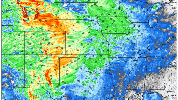
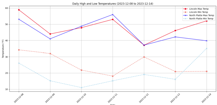
Precipitation was generally light for much of the state early-mid week, but northeast Nebraska had the best odds for wintry precip impacts, especially late Friday night into Saturday. The biggest impact I would like to mention was the near-record warmth in the southwest/central corridor midweek, especially near North Platte, with weekend lows dipping to around -10°F in far northeast Nebraska. I wanted to create a graphic highlighting the temperature contrast between North Platte in the west and Lincoln in the east, two distinct parts of the state with drastically different high and low temperature values. I also wanted to include our average precipitation for the state, which shows that we experienced below-normal precipitation values for the southern half of the state, while northeast Nebraska had some noteworthy precipitation values from the band of snow that moved southeast from the Dakotas.

After this weekend cold plunge, the atmospheric pattern for the 500mb level supports a warmer week ahead with highs returning to the 30s/40s Monday and 40s/50s Tuesday–Wednesday, and another windy day Thursday with a system brushing the region for central and eastern portions of the state, and especially in the west, with highs reaching as high as the upper 60s in the North Platte area.