Rain chances
Chances for a wet 4th of July are increasing, especially for west central and central sections of the state during the afternoon hours and in the eastern part of the state during the late evening and overnight hours. Recommend checking on the forecast over the next few days to see what is most likely to occur. But for now here are my thoughts.
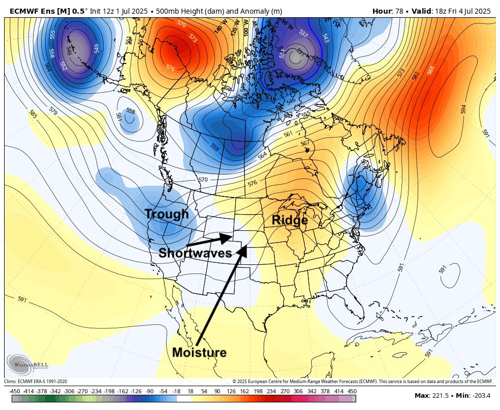
Figure 1. 500-mb height anomalies midday Friday
By Friday afternoon, a modest shortwave will have come from the base of the trough in the western U.S. into the High Plains region. The shortwaves will help induce the needed lift to produce rain/storms and access to some tropical Pacific moisture appears to be in place. This will help lead to a good chance of showers and thunderstorms in the eastern Panhandle and west central section of the state by midday on the 4th, perhaps even starting by mid-morning.
Showers and storms likely will work their way slowly to the east into central sections during the afternoon hours with the possibility for development ahead of the main line in eastern Nebraska if there is enough instability present. An outbreak of severe weather doesn't appear likely but this will need to be monitored. By later in the evening the main area rain/storms should be into eastern Nebraska with firework shows possibly being affected.
It won't be an all-day rain for anyone but certainly could send activities indoors for a few hours. Evening activities look good to go west of North Platte and perhaps could be good to go west of Highway 281. Evening activities may be cut short or need to be moved inside in eastern Nebraska. Except the fireworks. Unless you are trying to recreate the scene from the first Home Alone.
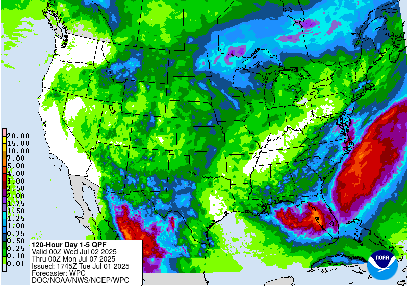
Figure 2. Projected precipitation amounts later this week
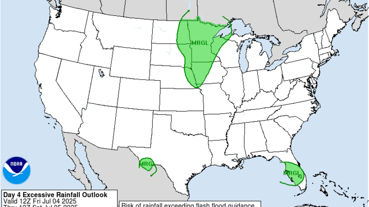
Rainfall amounts are forecast to be in the 0.25-0.50" for most of the state with better chances for an inch in southeast Nebraska where low-level moisture access may be maximized. The WPC does have the eastern sixth of the state in the marginal risk for excessive rainfall on Friday night. Western sections of the Panhandle may pick up some moisture on the morning of the 4th but may come out with nothing, which is unfortunate as they missed out on the rainfall feast that most of Nebraska had last week.
Tricky temperature forecast
The National Blend of Models projects high temperatures to be around 90°F statewide on the 4th. But I have low confidence in this forecast given the potential for a large portion of the state to be in rain and cloud cover for large stretches of the day. Temperatures in the upper 80's to low 90's may be more likely in eastern Nebraska if skies remain mostly sunny into the middle of the afternoon. That may be possible and if that is the case, it will be a muggy heat as dewpoints climb into the 70's. Heat index values certainly could exceed 100°F in that scenario in the eastern metro areas.
Areas stuck in rain and clouds likely will be held in the 70's to low 80's during the afternoon hours. But that is contingent on the timing of the system- a delay and these temperatures will be more achievable for all. A hot and steamy 4th of July will be closer to a guarantee to our east where ridging will be more prominent.
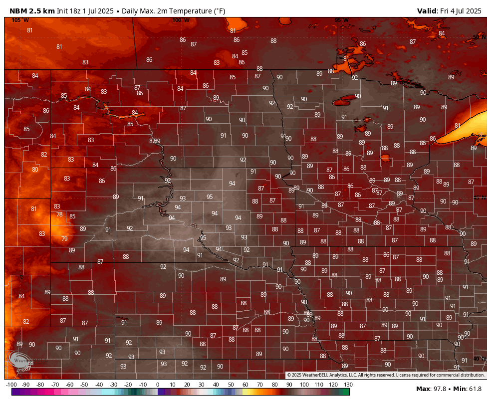
Figure 3. NBM projected high temperatures on Friday


