
Storm chances
The upper level ridge over the southwestern U.S. will temporarily flatten and retrograde, which will allow the ridge riding storms and cooler air to move south into the state starting tomorrow afternoon.

Figure 1. Projected 500-mb height anomalies on Thursday morning
Storms may fire along the cold front in northern sections of the state by mid-afternoon but the main complex will most likely develop in the late afternoon in western Nebraska and work its way east through the evening and overnight hours. Storms could be severe in western and central Nebraska and some areas could see brief periods of flash flooding. Another complex of storms will likely develop later Thursday in western Nebraska before sliding east-southeast. This may happen again Friday night into Saturday as well. Everyone in the state has a chance to pick up some moisture before the weekend but the best chance of over an inch is in south central and southeast Nebraska. Temperatures Thursday-Saturday will generally be in the 80's.
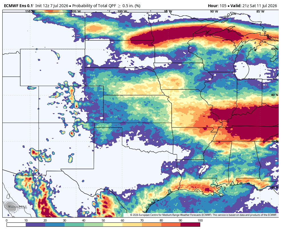
Figure 2. Probability of over a half inch of rain according to the ECMWF ensemble.
Heat wave
The rain that falls through Saturday will be the last rain most of us get until at least the following weekend. Models are in excellent agreement that a massive, possibly record setting, ridge will be building from the southwestern U.S. into the Dakotas early next week. The center of the ridge will be to our north, so it is not in the right spot to give us the worst possible scenario for a heat wave. Nevertheless, Mother Nature is getting ready to turn on the furnace for the whole region next week. Areas east of Lexington, NE can also count on uncomfortable levels of humidity too.

Figure 3. Projected 500-mb heights next Monday afternoon
Highs will be in the 90's statewide every day next week with 100-105°F probable in western and north central sections of the state during the first half of the work week. Temperatures could possibly exceed 110°F in parts of western South Dakota on Monday and Tuesday. Temperatures may also crack 100°F from eastern Nebraska into western Illinois later in the week if enough drier air can be mixed down. Winds look to be breezy from the south for most of next week as well and overnight temperatures will remain well over 70°F for central and eastern sections. The western part of the state will cool off more but will see minimum temperatures that are well above average.
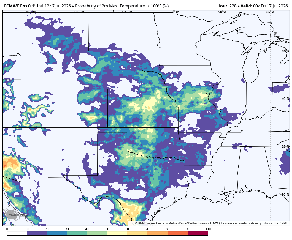
Figure 4. Probability of temperatures exceeding 100°F next Thursday
With corn ET at near-peak levels and most of the Central Plains and Western Corn Belt not dealing with major water stress, it is possible temperatures generally stay under 100°F in the eastern side of the state. But if it does, it will come expense of higher humidity and higher heat index values. A heat advisory or excessive heat warning will likely be in place for all of central and eastern sections of the state from Sunday through at least Friday. This will likely not set records but will be the warmest mid-July temperatures we have had in several years. It also is not good timing for corn going through pollination.
Mostly dry week next week
Rain will most likely be taking a hiatus next week as well with the ridge in place to our north. The Panhandle could start seeing better chances for showers and thunderstorms in the afternoon and early evening hours later in the week as the monsoonal moisture makes its way north. The lack of rain next week combined with the heat will likely start putting pressure on any fields that have been dry of late and don't get decent moisture the rest of this week. This dryness looks to extend throughout the Corn Belt as well.
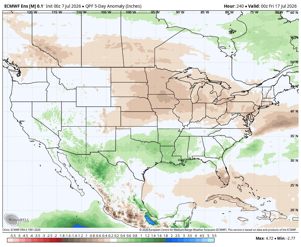
Figure 5. Projected precipitation anomalies next week
It does appear that the ridge will start to weaken later next week and move back to the southwest. This would open up better chances for showers and storms statewide around July 20th and temperatures cool back to closer to seasonal levels. In other words, this looks like a week of misery and not 20 straight days of misery. Nevertheless, next week will be dangerous for livestock and anyone that doesn't have access to air conditioning. It also could possibly start chipping away at yield potential in some areas in Nebraska and points east if the highest temperatures next week are realized.


