La Nina
We are currently in a weak La Nina and that is expected to stick around for the winter. We also are still in a negative phase of the Pacific Decadal Oscillation (PDO). The analogs are based largely on this combination, though other factors and teleconnections may play an even bigger role for our sensible weather this coming winter. Siberian snow cover in the fall can have a big impact on the strength of the polar vortex, as one example. Recommend following Dr. Judah Cohen's Arctic Oscillation blog for weekly updates if you are interested in the polar vortex. The phase of the North Atlantic Oscillation is a big wild card for our winter weather too but its predictability is not great at the seasonal time scale.
Warm November favored
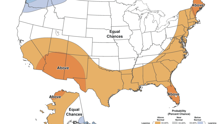
It has been a very warm October for this region of the country. For some parts of the Midwest it has been a record warm start to October. Some cooler temperatures are likely to pay us a visit next week but the month looks to finish out warm. Most indications are that November will also be a mild month for the state of Nebraska and most places east of the Rockies (Figure 1). Indeed, the seasonal outlooks from the ECMWF and historical analogs (2024, 2022, 2021, 2020, 2010) suggest that the month of November will be mild compared to historical averages. Of the five analogs, only 2022 brought colder than average temperatures to our region and that was after a warm start.
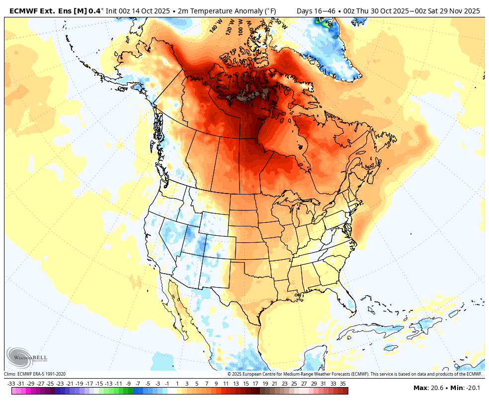
Figure 1. Projected temperature anomaly for the month of November
The ECMWF favors average to slightly above average precipitation across the state (Figure 2). The analogs also suggest that November may be wetter than average for the eastern section of the state with near-average elsewhere. November is not historically a wet month, so above average doesn't necessarily equate to several inches of moisture coming. But if troughing is more persistent in the western U.S., as is suggested in some global models and by analogs, the southwest flow would favor more moisture than average. This is especially true east of Highway 81 where access to Gulf moisture will be easier.
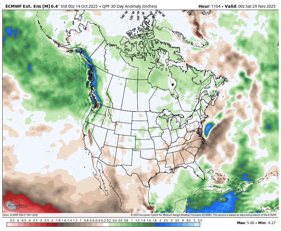
Figure 2. ECMWF projected precipitation anomalies
Colder winter temperatures?
There is less agreement on what is likely to transpire this winter. The CPC shows equal chances for above and below, which is a technical way of saying there is no signal. The ECMWF shows a mild start to winter followed by colder temperatures in the back half of winter. Most global models tend to overestimate winter temperature anomalies in the north central U.S. when we are not influenced by a strong El Nino, so I always take the outlooks with a little grain of salt. Nevertheless, it would be keeping with recent trends that we have a very mild start to winter before getting more cold in the second half of winter.
The analogs suggest that winter as a whole will be colder (Figure 3) for Nebraska and the entire north central region with warmer temperatures in the southeast. This is a pretty classic La Nina signature with a stronger temperature gradient between north and south.
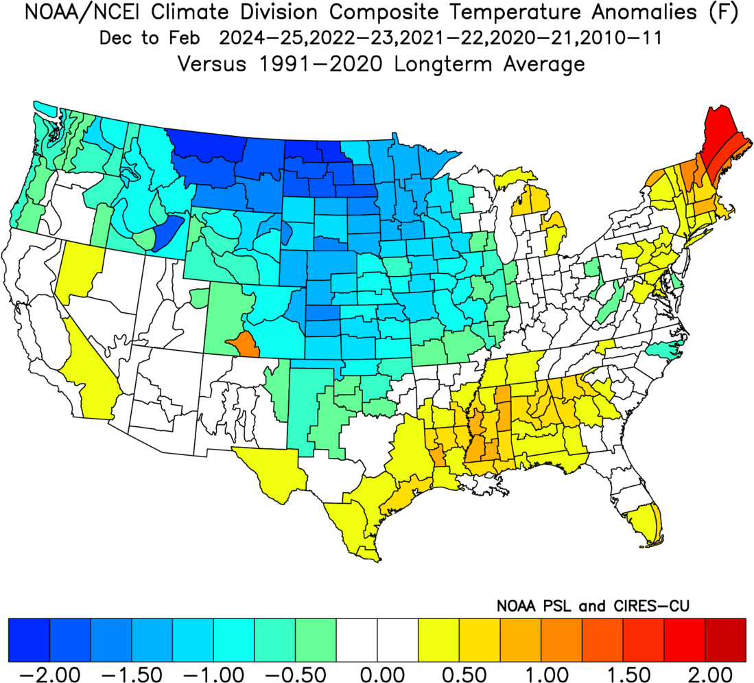
Figure 3. Composite anomalies from the analog years
Achieving these colder temperatures however would require a big pattern shift from what we have seen the last several weeks and what is projected into November. Figure 4 shows a composite of the 500-mb height anomalies, which reveals ridging in the North Pacific and over Greenland with troughing into the central U.S. The area to watch will be Greenland. If ridging is prominent there, that implies a negative NAO and more meridional (north-south) and less zonal (east-west) flow across North America and easier access to polar air. If there is also ridging set up in the North Pacific toward Alaska, the odds of colder temperatures for areas east of the Rockies goes up substantially. A pattern like this does seem to be suggested by the temperature anomalies in the ECMWF as we get into the back half of winter. If however, we maintain more troughing between the western U.S. and the Gulf of Alaska, the odds of cold will be reduced substantially.
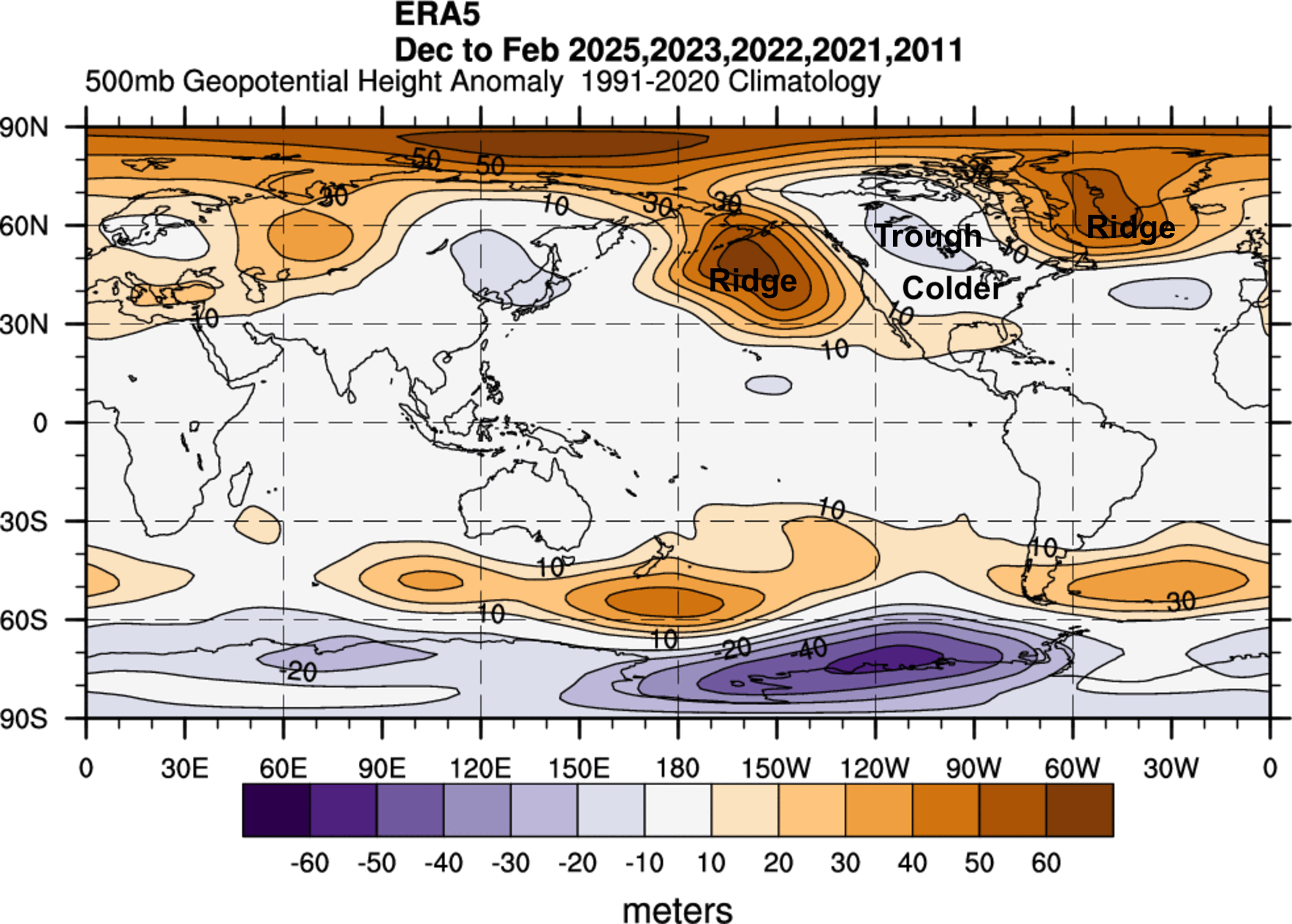
Figure 4. A composite of 500-mb height anomalies for the analog winters from the ERA5 reanalysis dataset.
How much snow are we going to get?
The answer to that question is more than 0 inches for everyone in Nebraska. All joking aside the amount of snow is fairly hard to project this far out (more so than temperatures) as one or two storms can have an outsized impact on overall snowfall totals. The analogs would suggest that overall precipitation would be around average for most of the state, with below average more likely in eastern sections of the state. It is, of course, possible to still have average snowfall in a winter season but below average precipitation overall, especially in southeast Nebraska.
But this also is a reflection that, on average, when we are under prevailing northwesterly flow in the winter, we may be fairly cold but not necessarily getting big snows with high moisture contents. In other words, 30 inches of snow may only yield an inch and a half of liquid water. Think of the typical 2-3" dry snow that blows around. To get the big snows, we really need deeper troughing in the West to give us southwest flow. That can help produce the more powerful surface lows that can give us the big snowstorms in our region. What we had in the first part of January 2024 is an example of that.

Figure 4. Precipitation anomalies based composite of the analog years
Drought outlook
The good news is that for the first time in several years many areas of the state are free of drought conditions and no one is in really bad shape. Thus, the prospects of a drier winter isn't as bad of news as it would have been a year ago at this time. Nevertheless, it will be critical to get some snow this winter to help preserve moisture that we do have and to reduce our wildfire risk going into next spring. Since winter is our driest season in an absolute sense, it would have to be near historically dry to see severe drought encompassing much of the state by next spring.
That is not a likely scenario and the CPC's Drought Outlook (Figure 5, valid through the end of December) does not show any new drought development in the state. But it's worth pointing out that the winter of '21-22 (one of the analogs) was near-record dry and some pockets of central Nebraska saw a 3-category degradation on the U.S. Drought Monitor and almost everyone saw some degradation. Just something to keep in the back of your mind but not something to worry about.

Figure 5. CPC drought outlook through the end of December


