
Coriolis
The Earth's rotation varies from roughly 1040 mph at the Equator to 0 at the poles. This difference in rotational speed means that objects moving poleward will appear to curve instead of traveling in a straight line. We call this apparent force the Coriolis force. It makes moving objects—especially air and ocean currents—appear to curve rather than travel in a straight line. The coriolis force is zero at the Equator and maximized near the poles. The equation is below:
f=2Ωsinϕ, where Ω is Earth's angular rotation rate and ϕ is the latitude.
In the Northern Hemisphere, objects are deflected to the right.
In the Southern Hemisphere, objects are deflected to the left.
Therefore, in the Northern Hemisphere rotation around high pressure is clockwise. Rotation around low pressure is counterclockwise. It is the exact opposite in the Southern Hemisphere because of the coriolis focrce.
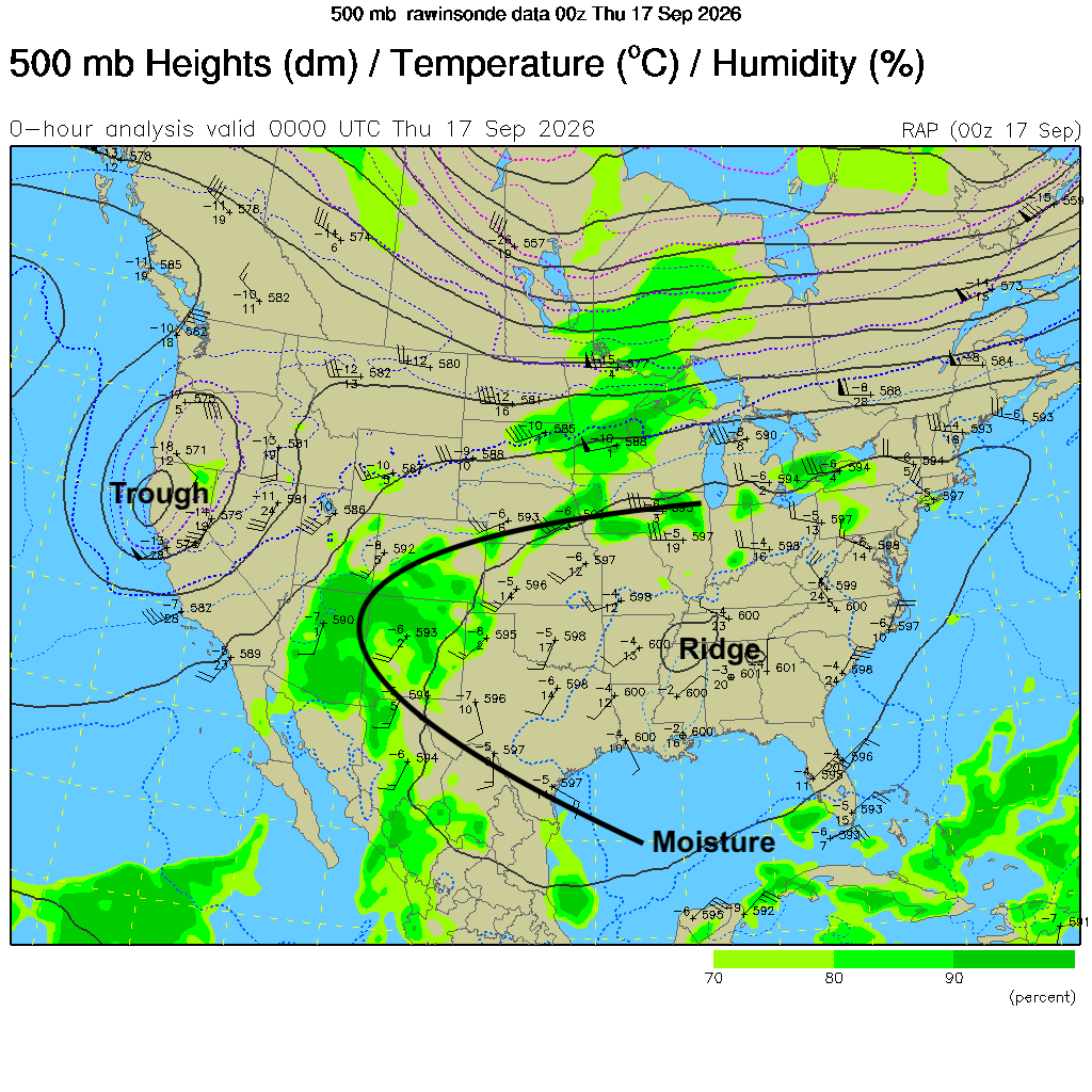
Figure 1. Upper air chart (500-mb) denoting ridges and troughs. Note the clockwise flow around the ridge of high pressure and the counterclockwise flow around the trough of low pressure.
Mother Nature redistributes heat
As we discussed earlier in the semester, areas poleward of 40° receive a deficit of sun while areas between 40° and the equator receive a surplus. The Earth wants to redistribute this surplus heat that builds up in lower latitudes to the higher latitudes, which have a deficit of solar radiation during the year.
The equator receives equal amounts of solar heating throughout the year. The surface and lower atmosphere are warm, which causes air to expand, become less dense, and rise.
As air rises, surface pressure decreases, creating the equatorial low-pressure belt, closely associated with the Intertropical Convergence Zone (ITCZ). The ITCZ shifts north and south with the changing of seasons, moving north during the Northern Hemisphere summer and south during the Southern Hemisphere summer.
In these areas, the rising air expands and cools, producing condensation, clouds, and rainfall. This is one reason many of the world's tropical rainforests occur near the equator.
So the basic relationship is:
0° → strong heating → rising air → LOW pressure → clouds and precipitation
30° deserts
The worlds deserts mostly are located around areas of 30° latitude. This is not an iron clad rule but many of the driest places are in this latitude belt (both northern and southern). Why is this?
The air that rises near the equator cannot continue upward indefinitely. Near the upper troposphere, it spreads poleward.
As this air moves toward higher latitudes, it eventually sinks. This descending branch of the Hadley cell produces the subtropical high-pressure belts.
Descending air is compressed and warms adiabatically, causing relative humidity to decrease. Consequently, these regions tend to have relatively clear skies and dry climates.
This helps explain why many of Earth's major deserts are located near 30° latitude—the Sahara, Arabian, Australian, and southwestern North American deserts.
30° → sinking air → HIGH pressure → generally dry conditions
At the surface, air leaving these subtropical highs flows both equatorward and poleward. The equatorward flow becomes the trade winds after being deflected by the Coriolis force.
It's wet and stormy at 60°
Some air leaving the subtropical highs travels poleward. At approximately 60° latitude, relatively mild midlatitude air encounters much colder polar air.
This region is associated with the polar front. Convergence and frequent weather disturbances encourage air to rise, creating the subpolar low-pressure belt.
Unlike the equator, the rising motion here isn't primarily caused by intense surface heating. It is strongly connected to large-scale weather systems, fronts, and atmospheric dynamics. This is why the mid-to-high latitudes around 50–60° frequently experience cyclones and rapidly changing weather. It is why our polar jet tends to live up here in the summer and goes south in the winter

60° → convergence and rising motion → LOW pressure → frequent storms
Santa's home
At the poles, there is very little incoming solar energy, particularly during winter. The atmosphere becomes extremely cold and dense. Cold, dense air tends to sink, producing the polar highs. At the surface, air flows away from the poles toward lower latitudes. The Coriolis force deflects this air, creating the polar easterlies.
90° → very cold, dense, sinking air → HIGH pressure
The three-cell model
Putting everything together gives an alternating pattern of rising and sinking motion:
| Latitude | Vertical motion | Surface pressure | Major feature |
|---|---|---|---|
| 0° | Rising | Low | ITCZ |
| 30° | Sinking | High | Subtropical highs |
| 60° | Rising | Low | Subpolar lows / polar front |
| 90° | Sinking | High | Polar highs |
These vertical motions define the three circulation cells:
Hadley cell: 0–30° — thermally direct circulation, with warm air rising near the equator and sinking in the subtropics.
Ferrel cell: 30–60° — an indirect circulation maintained largely by midlatitude weather systems and eddies. Surface flow is generally poleward, producing the prevailing westerlies.
Polar cell: 60–90° — cold air sinks over the poles, moves equatorward near the surface, and rises again near the polar front.
The result is the characteristic global sequence:
90° HIGH → 60° LOW → 30° HIGH → 0° LOW → 30° HIGH → 60° LOW → 90° HIGH


