
Day by Day
- Sunday, June 21st, severe storms and significant rainfall were seen in several parts of the state. More information about these storms can be found in our last article.
- On Monday, easterly upslope flow initiated more severe storms in the panhandle in the afternoon. These storms produced a max wind gust of 77 mph 4 miles northwest of Terrytown, 2.75-inch hail in Scottsbluff and 2 miles west of Gering, and two landspouts 4 miles southwest of Kimball. For the rest of the state, Monday was a few degrees cooler than previous years, and this trend will continue.
- Overnight and into the early afternoon on Tuesday, those storms moved eastward with below-average temperatures, with the majority of the state in the 70s. Roughly half the state received rainfall, with a station 1 mile NW of Hayes Center receiving 2.1 inches, the highest of the day.
- Although Wednesday had slightly higher maximum temperatures statewide, they were still below the average maximum temperatures of previous years. In the evening into overnight hours, thunderstorms, a few of which were severe and produced 77 mph winds 3 miles E of Grant and 2.75-inch hail 2 miles NNE of Wauneta, over southwestern Nebraska, moved east-southeast.
- By Thursday morning, 2.82 inches of rain had fallen over the last 24 hours, 4.9 miles NW of Benkelman, leading to flooding in the region. Thursday continued the trend of below-average temperatures and increased rainfall, with the panhandle receiving the largest amount.
- On Friday, the ridge centered over TX, NM, and the Mexico border weakened, and a trough began moving into NW CONUS during the day. Surface winds would start backing to the south, bringing up moisture from the Gulf.
- To finish the week, Saturday saw a statewide rise in temperature, with the largest increase occurring in the panhandle. Another round of storms would occur in the panhandle and move northeast throughout the night, resulting in 2.06 inches of rain 2.5 miles NE of Valentine.
Overall, the weather was mild and wet over the week, right before the start of a heat wave.
Weekly Charts
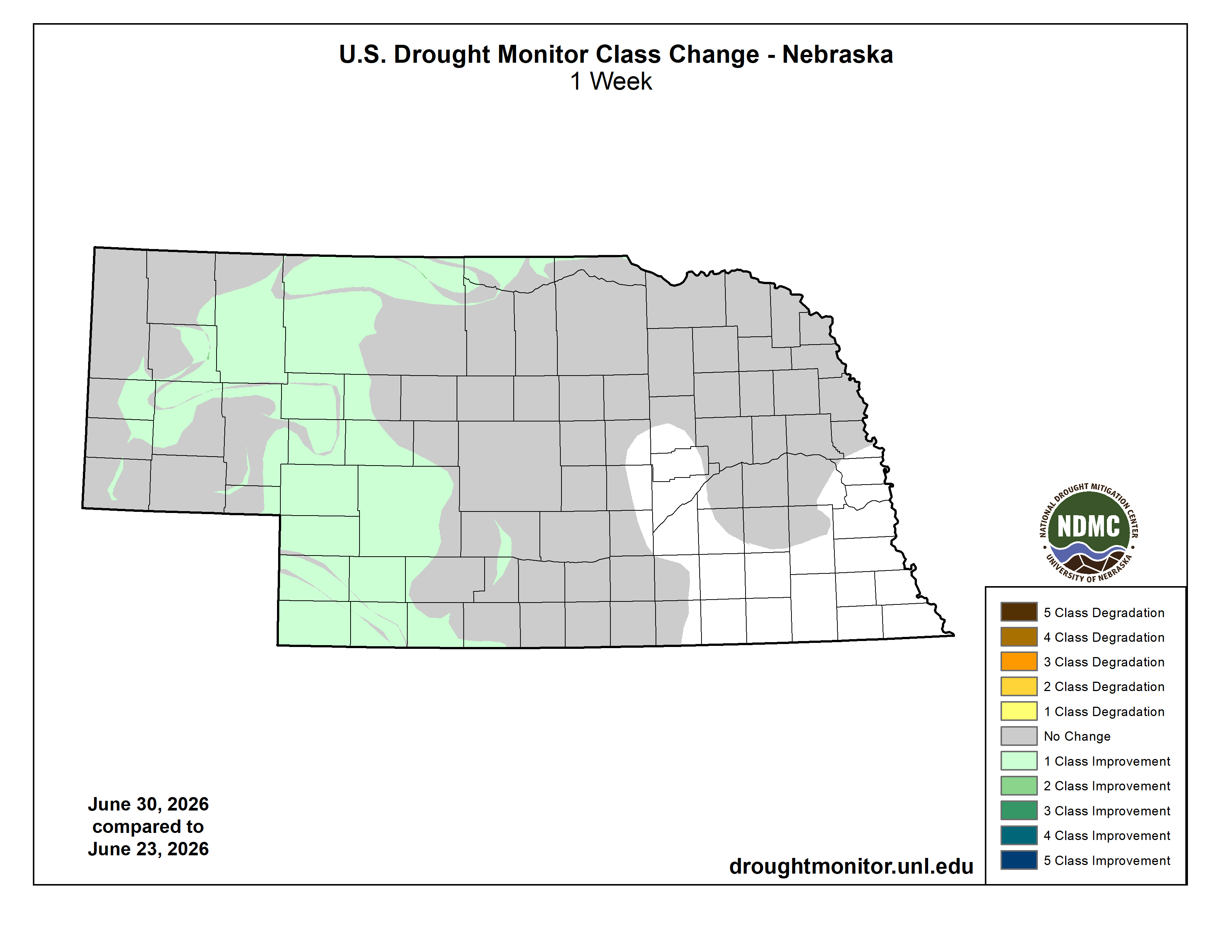
Figure 1. U.S. Drought Monitor class change for June 30th.
This large amount of rainfall and cooler temperatures allowed drought conditions to improve, with a one-class improvement stretching from southwest Nebraska to the northern border and parts of the panhandle.

Figure 2. Maximum observed temperature in Nebraska over the week.
The highest temperature observed in the state was 96°F at the Sidney Municipal Airport on the 27th.

Figure 3. Minimum observed temperature in Nebraska over the week.
The lowest temperature was 44°F 4 miles north of Table Rock on the 21st.

Figure 4. Total precipitation in Nebraska over the week.
The highest total precipitation was 5.59 inches 1 mile north of Trenton Dam.


