
Weekly Overview
Sunday, June 28th, marked the start of a heat wave, with temperatures rising into the 90s across most of the state. Southerly winds would continue to slowly transport moisture from the Gulf of Mexico into Nebraska, leading to unpleasant conditions.
This heatwave would continue for the rest of the week, with several stations breaking or matching previous maximum temperatures most days. The peak of the heat would be on the 29th and 30th, when most of the state was in the 90s and high 80s. The highest temperature recorded was 100 degrees on the 30th in Red Cloud.
These air temperatures were paired with dangerously high dew points, resulting in the issuance of heat advisories for most of eastern Nebraska. Extreme heat warnings were also issued for Sarpy and Douglas counties from the 28th through the 30th, and for Dakota County from the 29th through the 30th.
As eastern Nebraska was stuck with extreme temperatures, severe weather hit the rest of the state. In the early morning of Sunday, June 28th, severe thunderstorms moved through north-central Nebraska, bringing rainfall totals of 2.06 inches in Valentine and 79-mph winds in Mills.
Over the rest of the week, the pattern continued: consistent severe weather driven by abundant Gulf moisture, a strong ridge to the southwest, and multiple fronts and outflow boundaries that contributed to its development.
Hail and destructive winds caused widespread damage. The largest hailstone, measuring 2.75 inches, fell in Sheridan County in the early morning of June 29th, and another hailstone measuring 2.75 inches fell in Hitchcock County in the evening of July 2nd. In addition to the severe hail, there were several reports of extreme wind across the state, the most impactful in Madison County in the early morning of June 30th. This report was for 101 mph winds, which destroyed a well-anchored carport.
Tornadoes were also warned and reported from the 29th to the 2nd, with one on the ground in Stanton County in the early morning of the 30th and another in Thayer County in the evening on the 3rd. The tornado in Stanton County impacted a farm, destroying a barn, damaging several trees and a grain bin, and removing shingles from the roof of a home before lifting.
By the end of the week, repeated rounds of severe weather and rain shifted the primary threat to flooding. On the night of July 2nd into July 3rd, several flash flood warnings were issued for Dundy and Hitchcock Counties following reports of washed-out and impassable roads, backed by a rain gauge reading of 4.03 inches in Dundy County observed on the morning of the 3rd.
In addition, the opposite side of Nebraska received several flood advisories, followed by flash flood warnings, on June 30th and July 3rd. These events are confirmed by rain reports of 2.62 inches in Antelope County on the 30th and 4.14 inches in Cedar County on the 3rd.
The late-week weather pattern continued to disrupt Fourth of July festivities statewide. On the evening of July 3rd, widespread severe thunderstorms and torrential rain forced community organizers to delay scheduled fireworks shows.
By the 4th, a stagnant air mass trapped fine particulate smoke from holiday fireworks near the surface, pushing PM2.5 readings to 163 in both Lincoln and Omaha—levels considered "Unhealthy" for the general public. These were the worst air-quality readings across the country due to a lack of wind and an inversion just above the surface that trapped smoke.
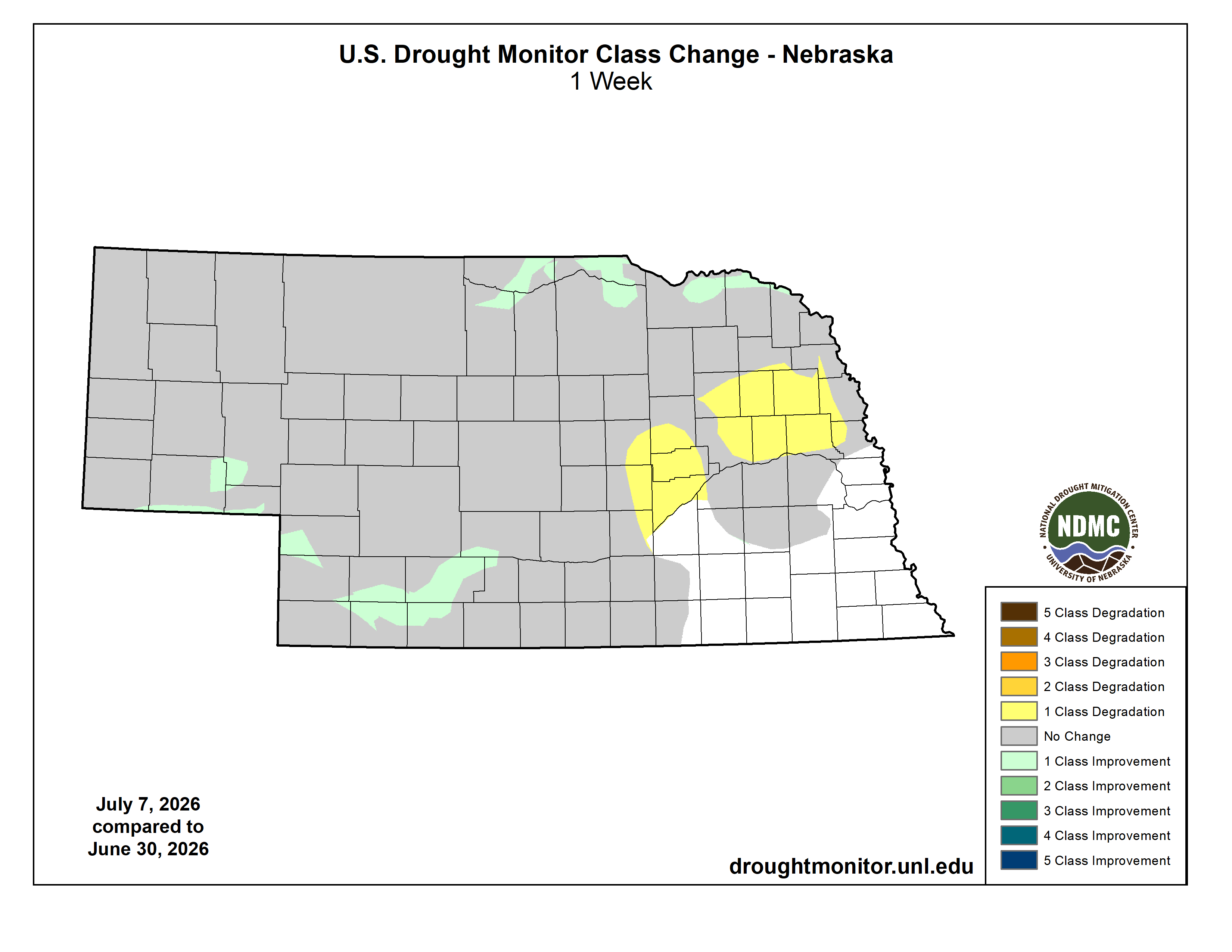
Figure 1. U.S. Drought Monitor class change map of Nebraska.
We saw some improvement in portions of extreme northern Nebraska for drought conditions and in southwestern Nebraska. However, the extreme heat and minimal rainfall in east-central Nebraska did lead to 2 areas with a one-class degradation. The more western area is now D0 abnormally dry, and the eastern class degradation area bumped the area to a D1 moderate drought.
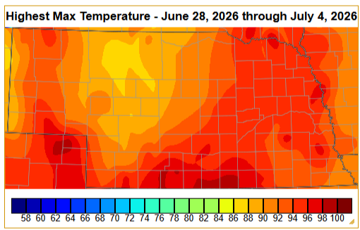
Figure 2. Maximum observed temperature in Nebraska over the week.
The highest temperature of the week and the heat wave was on July 30th, when Red Cloud, which is located in south-central Nebraska, reached 100°F.
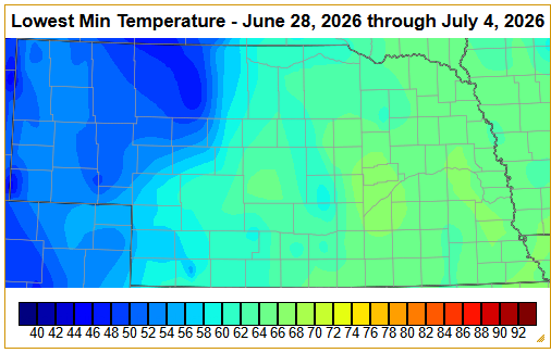
Figure 3. Minimum observed temperature in Nebraska over the week.
Interestingly, the lowest temperature was also observed on the 30th, where a station 20 miles south-southeast of Harrison measured 36°F.
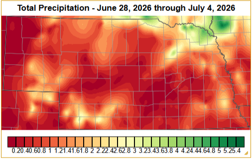
Figure 4. Total precipitation in Nebraska over the week.
5.2 inches of rain fell 4.1 miles southwest of St. Helena, located in extreme northeastern Nebraska.


