
Chances for showers and storms
A quick look at surface analysis shows high pressure sitting over eastern Nebraska. Skies are mostly clear and it is a very pleasant day overall across the Central Plains and Western Corn Belt. It is a bit warmer with winds turning southerly in the Panhandle. But the ridge across the southwestern U.S. is starting to build back toward the east. With a series of atmospheric shortwaves coming in from the northwest and moisture coming up with the low-level jet overnight, this will help open up chances for showers and storms across central and eastern Nebraska later tonight and tomorrow morning. A more potent shortwave rolls in later on Friday but right now the best chance for widespread showers and storms will be across northeast Nebraska into western Iowa.
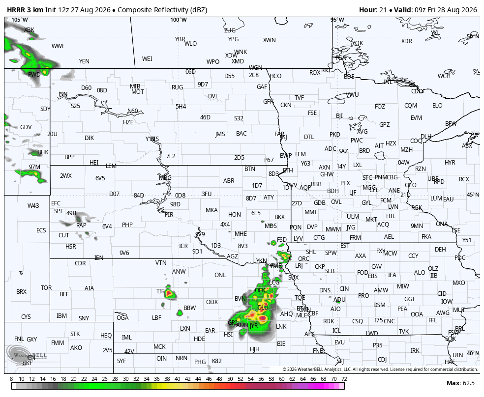
Figure 1. The 12Z's HRRR forecast for precipitation at 4:00 CDT on Friday morning.
The heat is on
With that ridge building back to the east into the southern Rockies this weekend, this will help expand the heat back to the north and east.

Figure 2. Projected 500-mb height anomalies on Saturday
High temperatures on Saturday are going to be in the 90's statewide with highs over 100°F probable in southwestern Nebraska. It will also be breezy from the southwest by Saturday afternoon as well, especially in areas east of Highway 83.
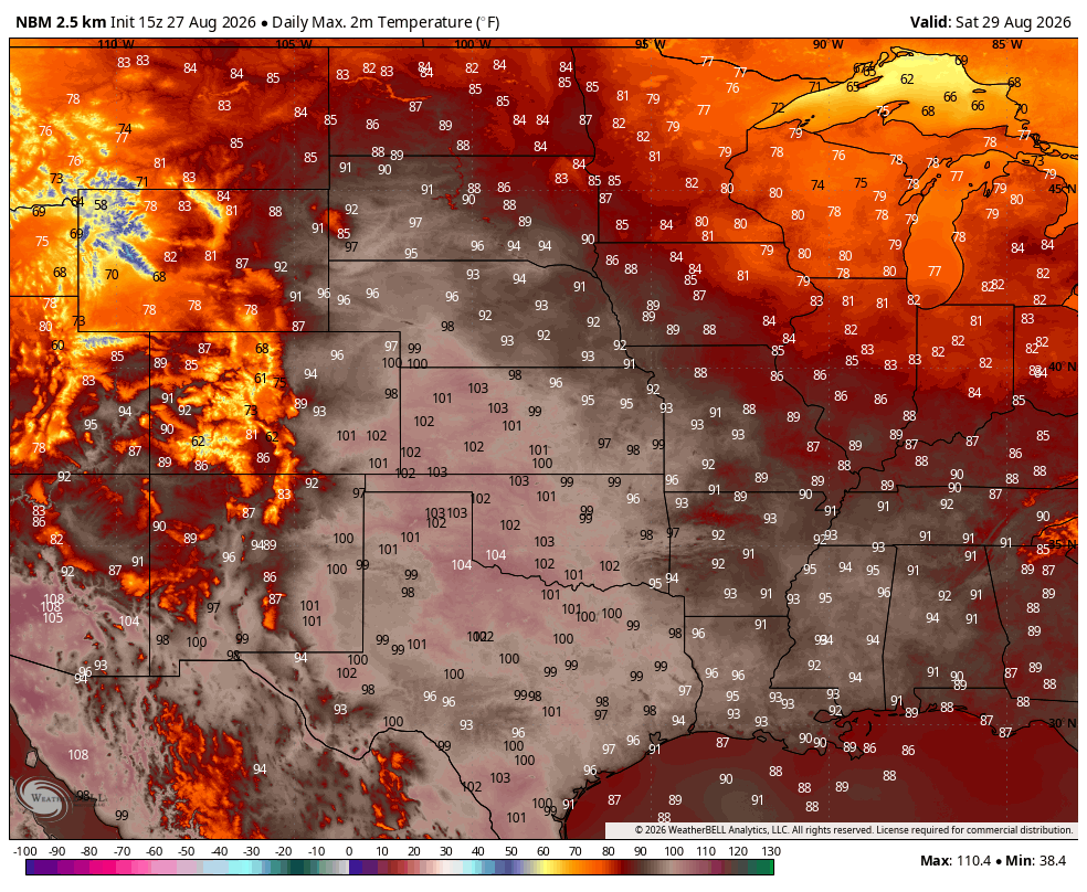
Figure 3. Projected highs on Saturday
Temperatures remain hot on Sunday with temperatures in the 90's statewide. Some model runs show temperatures flirting with the upper 90's between Omaha and Des Moines on Sunday afternoon. Lows will be well above average statewide on Sunday morning and may not drop out of the upper 70's in southeast Nebraska. This would be pushing record warm territory for minimum temperatures in late August should those temperatures come to fruition. Winds will remain breezy from the southwest on Sunday in eastern Nebraska, which means lower atmospheric mixing will be optimized. Rainfall has been plentiful over that area over the last 3-4 weeks and crops are still transpiring, so that plus shortening days will help limit temperatures somewhat. But it may well be the hottest day so far this month for much of eastern Nebraska.
Relief?
By Monday a weaker upper-level trough is likely to move into Manitoba and a surface cold front will extend out ahead of it down into Nebraska. Most of the northern and western sections of the state should be noticeably cooler on Monday afternoon with temperatures in the lower to mid 80's.
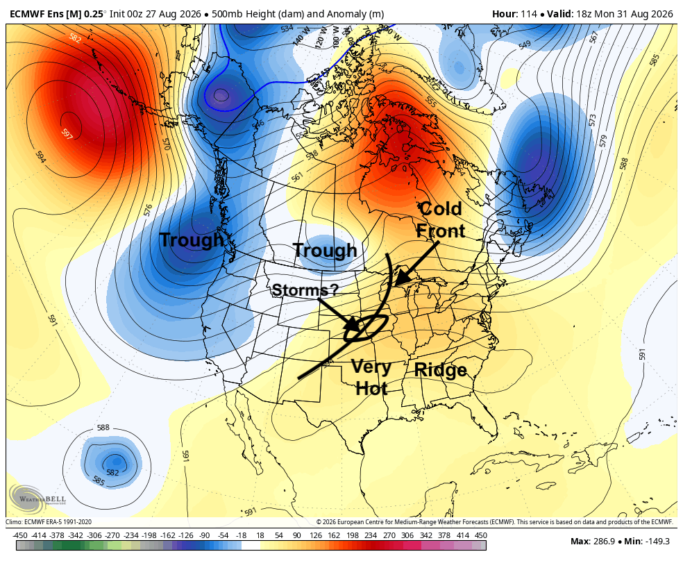
Figure 4. Projected 500-mb height anomalies on Monday
How far southeast the front makes it by late Monday into early Tuesday is still in question. If it is a faster moving front, then even southeast Nebraska could see some relief on Monday afternoon. It is probable storms develop along and behind the front later Monday into early Tuesday. Current indications are that the storms would form between Highways 30 and 136 and move east-northeast. The WPC is not currently bullish on significant moisture between Monday afternoon and Tuesday. But the models performance with projections of precipitation totals this summer has not been stellar. So, don't be too shocked if pockets in the Central Plains and Western Corn Belt pick up over half an inch of rain.
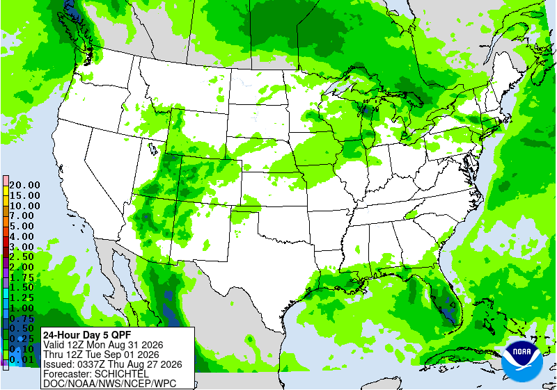
Figure 5. WPC's projected precipitation totals between Monday morning and Tuesday morning
Warm with chances of storms
Temperatures on Tuesday and Wednesday will be contingent on how where the front is and how much lingering cloud cover and rain there is during the morning hours. But highs in the 80's and lows in the 60's would seem a good bet for most of us those days. The upper level ridge likely will build back to the north again and the aforementioned cold front will come back through the state as a warm front during the middle of the week. This would put most, if not all, of the state in the warm sector by Thursday with highs in the upper 80's to 90's being likely.

Figure 6. Projected 500-mb height anomalies on Thursday
The big question for Labor Day weekend will be what happens with the trough in the Pacific Northwest and how entrenched the southern ridge remains. If it is able to make it into the Northern Plains this weekend as suggested by recent ECMWF AI runs, that would drive a cold front into the state and would help open up chances for showers and storms along of it and bring some cooler air in temporarily after its passage. Western Nebraska would get a nice taste of fall if that happens. Ahead of the front the heat will be on with temperatures likely being in the 88-95°F range.
The calendar will say September but it can still be very summer-like in the first part of the month and in the last 20 years, it's been common for summer to stick around well into September. The CPC's outlook suggests that is likely to be the case again this year as the ridging over the south-central U.S. will be stubborn. While not every day in the first half of September will be above average (some cooler weather is probable around Labor Day), we are not going to be done with summer's heat until probably closer to the equinox.
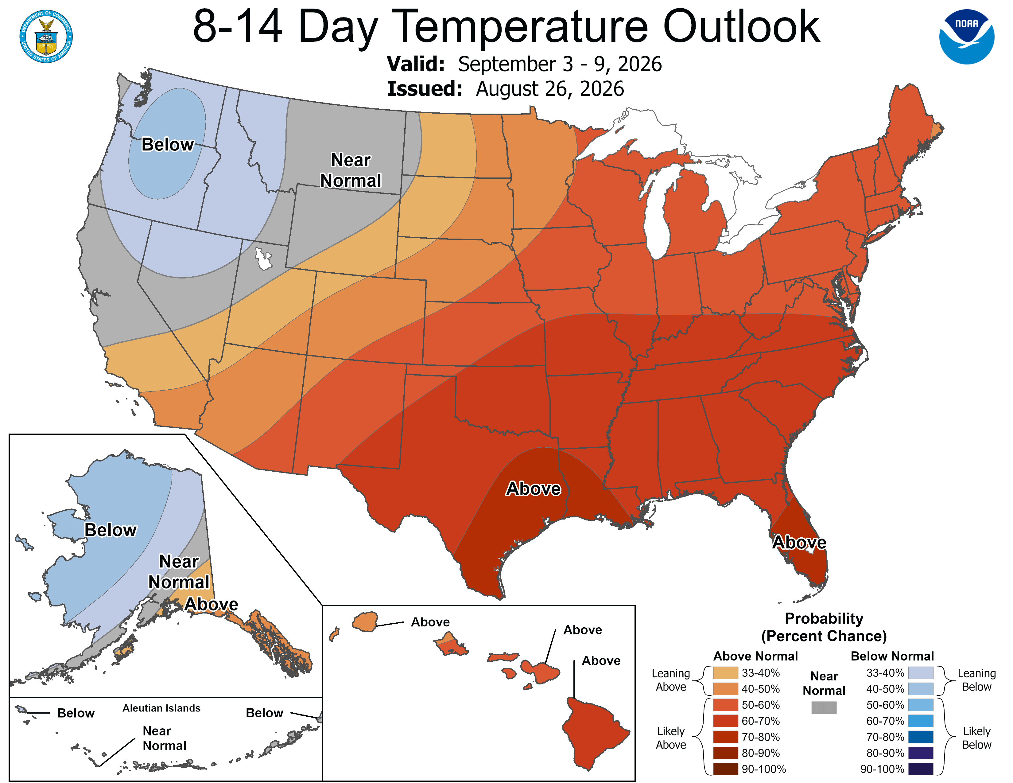
Figure 7. CPC's 8-14 day outlook


