
Well above average temperatures
Temperatures have been quite warm for early October in recent days and that warmth will continue as upper level ridging remains dominant over our region. Highs tomorrow may exceed 90°F in parts of western Nebraska and should be well into the 80's almost everywhere. Winds will also pick up from the south tomorrow morning and likely will be in the sustained 10-15 mph range by tomorrow afternoon statewide. It will be breezy overnight Friday, especially east of Highway 83.

Figure 1. Projected high temperatures on Saturday
Highs on Saturday will remain well above average (quite possibly 4-6°F above the projected values in south central and eastern NE) across the region and winds will be quite gusty on Saturday afternoon as a tight pressure gradient will exist between low pressure in eastern WY and high pressure to the east. Wind gusts from the south could exceed 40 mph at time in central and eastern Nebraska, which could make the kicking game more on Saturday interesting.
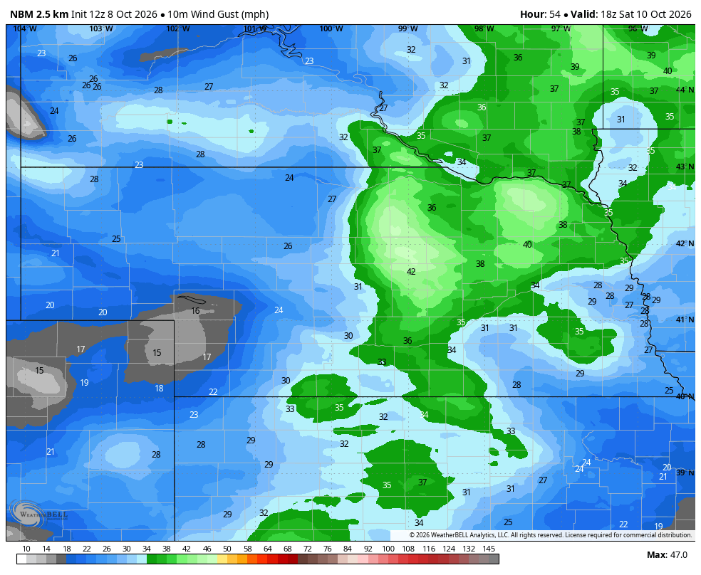
Figure 2. Projected wind gusts early Saturday afternoon
Cold front
One more warm breezy day is on tap for most of the state on Sunday with highs mostly in the upper 70's to mid 80's. By late in the day a cold front will start moving through the northwestern part of Nebraska and should clear the entire state by late Monday. Temperatures behind the front on Monday will be considerably cooler (50's and 60's) and ahead of it, another day in the 70's to lower 80's is likely. Some areas in central and eastern Nebraska could see a big dropoff between the early and late afternoon hours. The front should come through mostly dry and temperatures Tuesday will be mostly in the 50's and lower 60's. For central and eastern sections, this will be the coolest air so far this fall.
Rain chances
A trough in the west will start to move toward the central U.S. by the middle of the week. Rising motion ahead out of the trough will open up chances for moisture by later Tuesday. The period between Wednesday and Thursday morning could be rather wet, especially for the eastern half of the state. WPC shows a quarter inch being probable in the northern Panhandle but most of western Nebraska could miss out on the best moisture yet again. A half inch of moisture is a better bet in eastern Nebraska with higher probabilities of 1-2" across southeast Nebraska.
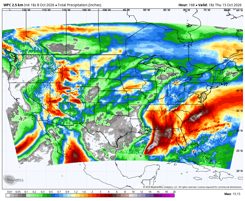
Figure 3. Total precipitation expected through next Thursday afternoon according to the WPC
First freeze?
Models are not in great agreement about the amount of amplification in the upper air pattern later next week. Nevertheless, there is potential for a large ridge to develop off the west coast with a downstream trough somewhere in the central Rockies. If the storm takes a more southerly and slow track, there will be chances for rain statewide and possibly even snow in the western half of the state next weekend. It would also be much colder. If it's north of us and faster, we may see chances for severe storms in eastern Nebraska late in the week and a powerful cold front swinging through next weekend.

Figure 4. Potential 500-mb anomaly map next Friday
In other words, the forecast for late next week is rather uncertain. But I would say with some degree of confidence that at least 1-2 days of cooler, perhaps much cooler, temperatures is likely by the end of next weekend. A freeze seems probable for western and northern sections and may be possible elsewhere. This would be one of the latest first freezes on record for some areas of western Nebraska but would be seasonal if we did see a freeze in say Crete or Auburn. Regardless, our nights are getting longer quickly and the death certificate for this growing season isn't too far off.


