
Stormy times ahead
The latest upper level water vapor analysis shows clusters of storms along the Gulf Coast, storms in the southern Plains around a stalled out front, ridging off the Pacific Northwest, and a couple of troughs in the Pacific. The trough currently closest to California will be making its way east over the next 48 hours and a surface low is expected to develop in eastern Colorado by Saturday. By then high surface pressure will be over the southeast, which will pump moisture up from the Gulf back into the Plains.
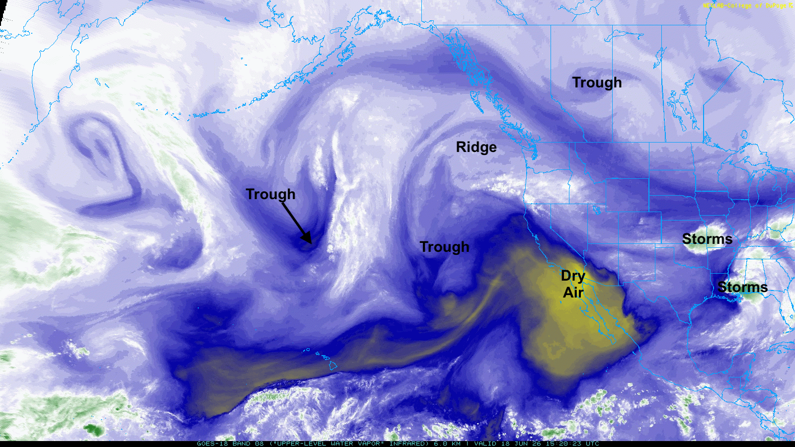
Figure 1. Upper level water vapor analysis
Winds should be out of the southeast across the state by Saturday afternoon, which means moisture should be getting at least into the eastern Panhandle and western Sand Hills in time for convective initiation on Saturday afternoon. Right now it appears storms should form in the afternoon hours between Highways 385 and 83 and start working their way east through the state on Saturday evening into Sunday morning.
Severe weather and flash flood potential
The Storm Prediction Center has much of the southwest and south central sections in the slight risk category for severe weather on Saturday afternoon/night with a marginal risk elsewhere. Reasonable chance that more area is included in that slight risk category and the area around North Platte may get upgraded to an enhanced risk. Large hail will be the biggest threat but tornadoes and damaging winds would also be possible. Wind shear will be present and with the upper level trough coming into the area (with colder air aloft), the lapse rates will be steep. The deep low-level moisture will also lead to very effective rainfall producing storms.
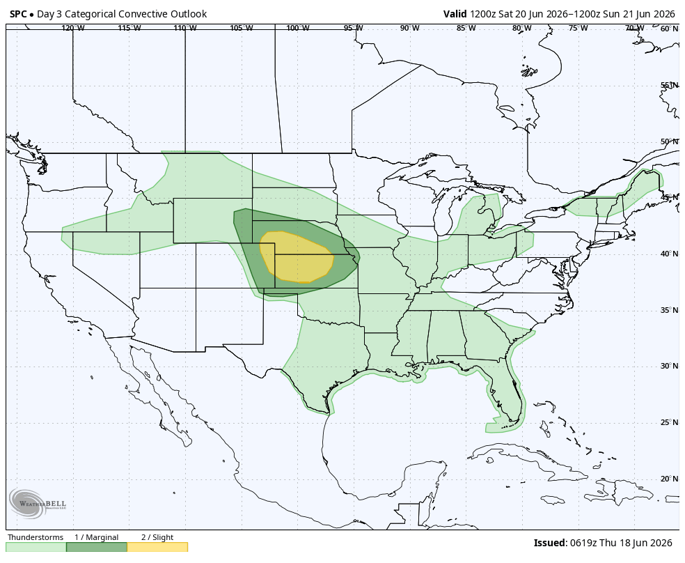
Figure 2. Storm Prediction Center's severe weather risk on Saturday into early Sunday
The biggest risk for the eastern half of the state could be the possibility of flash flooding. Heavy rainfall is rather likely and rainfall rates of over 2" per hour may be possible in the I-80/Highway 34 corridor. The WPC paints a broad area of 2" plus across the eastern 2/3 of the state with an area of 4" plus around Grand Island. Rain rates likely will be more than can be infiltrated in a few hours, so flood watches are likely going to be issued for much of central and eastern sections. The good news is this area has not had much moisture in the last several days and thirsty crops are using previous moisture up, so the ground still has capacity to hold a good rain. But the rain rates should be taken seriously and it wouldn't shock me if someone in central or eastern Nebraska got 6".
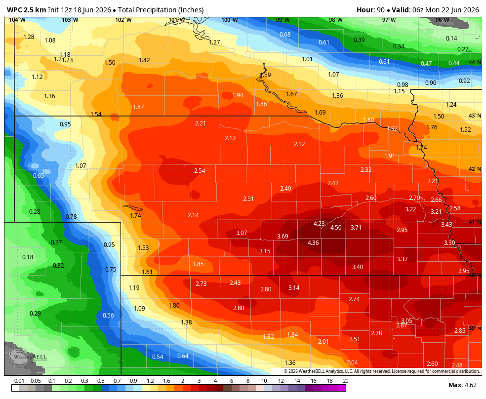
Figure 3. WPC's precipitation projections through early Monday morning.
Cooler weather
A cold front will push through on Sunday night and will bring in seasonally cool temperatures with lower humidity statewide on Monday. The eastern half of the state looks to be dry and pleasant on Tuesday but upslope flow will lead to good chances for showers and thunderstorms in western Nebraska. WPC isn't bullish on significant precipitation but any moisture in this part of the state is welcome.
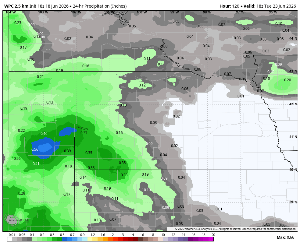
Figure 4. Projected precipitation on Tuesday (June 23rd)
The remainder of the week will feature below average temperatures with highs from the mid 70's to low 80's and low temperatures generally in the 50's. Wednesday may be the warmest day of the week (low to mid 80's) before a cold front comes through. Showers and thunderstorms would be probable for much of the state late Wednesday into Thursday. Additional storm chances will be possible on Friday afternoon/night.
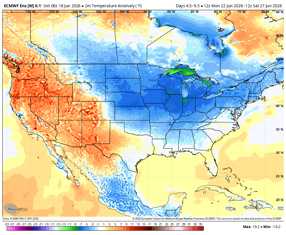
Figure 5. Projected temperature anomalies between next Monday and Saturday
Upper level ridging looks to make a return to the eastern U.S. toward the end of the month with troughing coming back into the western U.S. This would bring back the warmer weather and humidity in about 10 days and it would also keep the faucet on. Recent ECMWF AI runs have been showing significant rainfall across the western and central Corn Belt along a slow moving front around the 1st of July. The CPC's 8-14 day precipitation outlook is also showing above average precipitation, which would be great news for the western half of the state where drought is still a major issue.
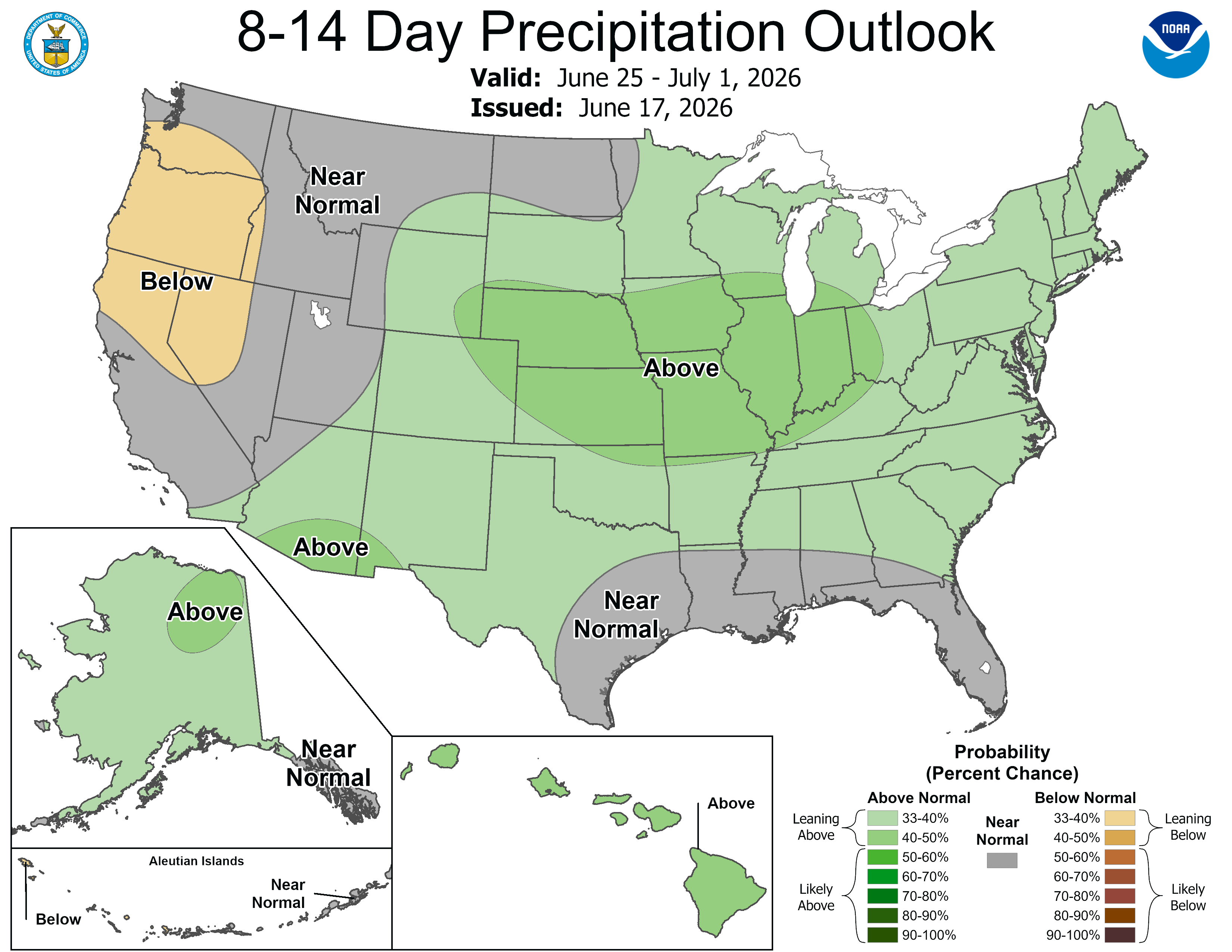
Figure 6. CPC's 8-14 day precipitation outlook


