
Hot and chances of severe storms tomorrow
Temperatures will shoot back up into the upper 80's and lower 90's across most of the state tomorrow ahead of a cold front. Winds will breezy out of the south-southwest in central and eastern Nebraska ahead of it and westerly in western Nebraska behind it. By early evening, storms may develop across central and northeast Nebraska and slide east-southeast into southeast Nebraska and Iowa. How widespread the storm coverage will be is a little unclear but the SPC does have northeast Nebraska in the slight risk area for severe storms.
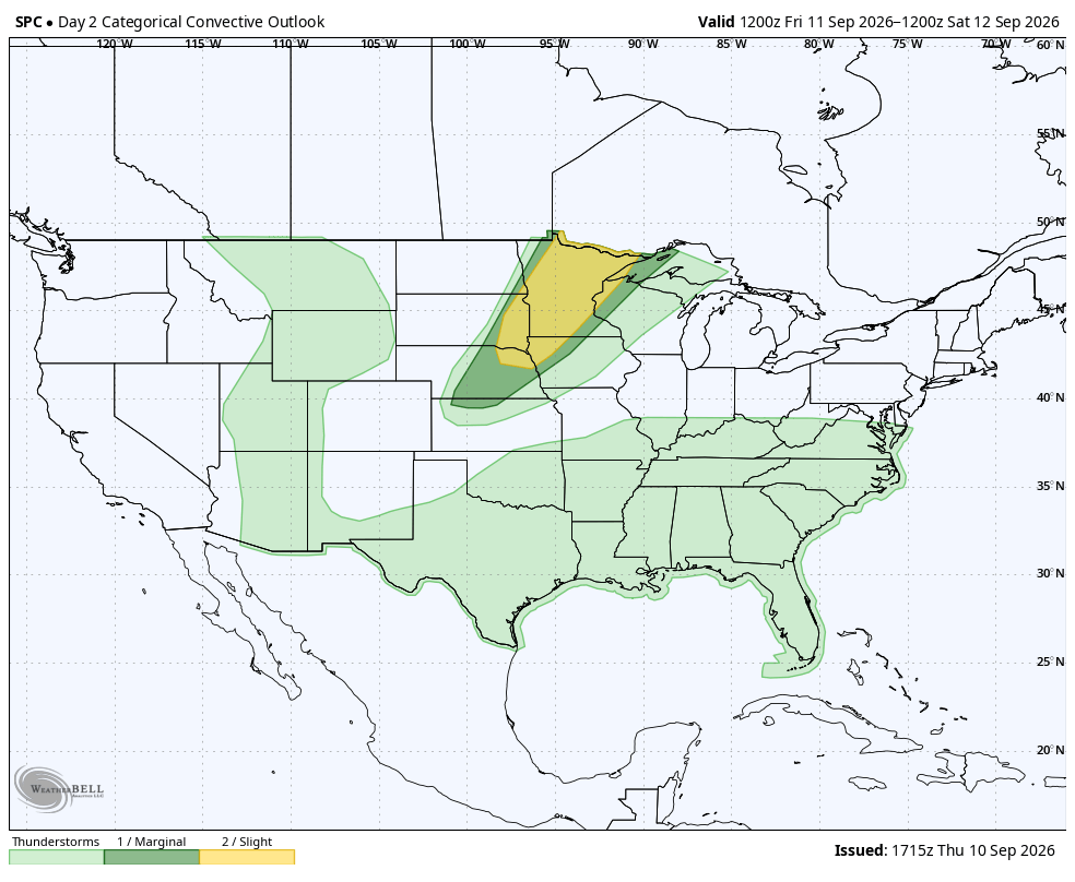
Figure 1. SPC's severe storm risk for tomorrow night
Pleasant conditions for the football game
A week ago it looked like another warm start to the Nebraska game but with the front passing through the state by Saturday morning, temperatures on Saturday evening should be reasonably pleasant with temperatures in the lower 70's, dew points in the low 60's, and a gentle breeze from the northeast.
Rain/storms Sunday east
The pleasant weather Saturday evening will give way to a good chance for showers and thunderstorms across the eastern half of the state as a shortwave moves in from the northwest. Over half an inch is probable in southeast Nebraska. The rain and clouds will keep the eastern section of the state cooler. Western areas of the state are likely to see breezy winds from the south and temperatures shooting back into the 80's.
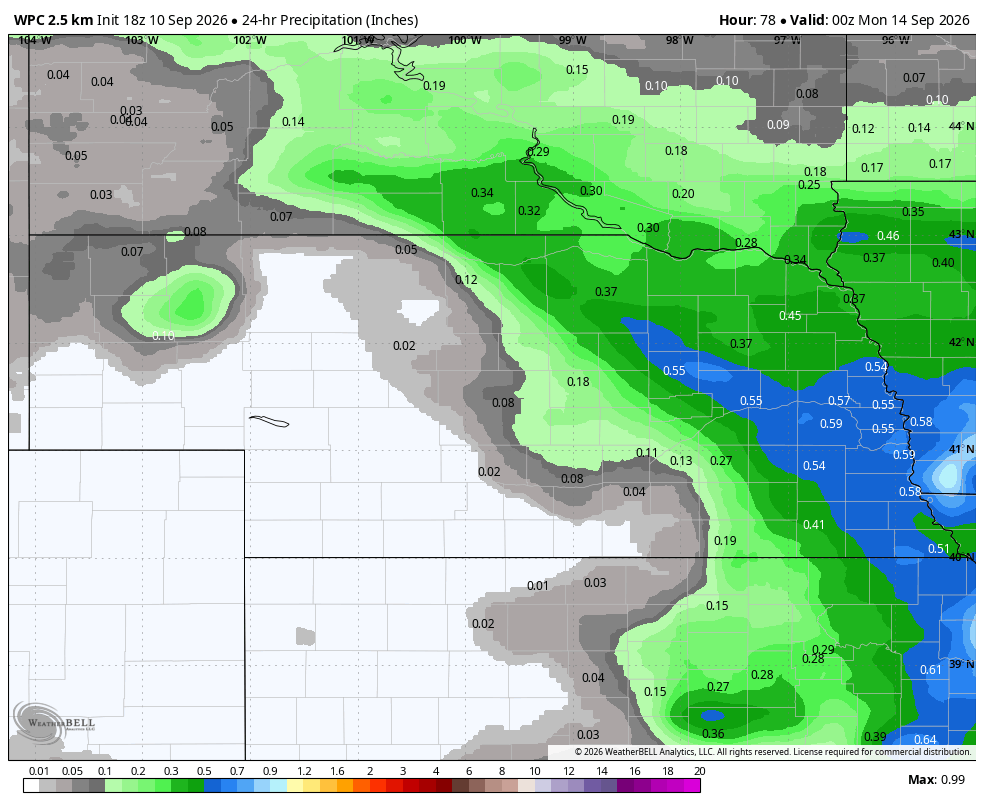
Figure 2. Expected rainfall on Sunday
Another cold front
An upper-level trough will move into the northern Plains on Monday and at the surface a cold front will start to move into the state. Temperatures in western Nebraska behind the front should be in the mid 70's to lower 80's. Ahead of the front much warmer conditions will prevail with highs at least in the 80's if not in the 90's for much of central and eastern Nebraska.

Figure 3. Projected 500-mb anomalies on Monday afternoon
Showers and thunderstorms will likely develop along and behind the front on Monday night in southern and eastern sections of the state. Heavier precipitation may fall across the southeastern portion of the state. It's also possible for some heavier rainfall across portions of central Nebraska, which could make Husker Harvest Days interesting. Temperatures will likely be cooler statewide on Tuesday and may be 20°F cooler in south central and eastern Nebraska.
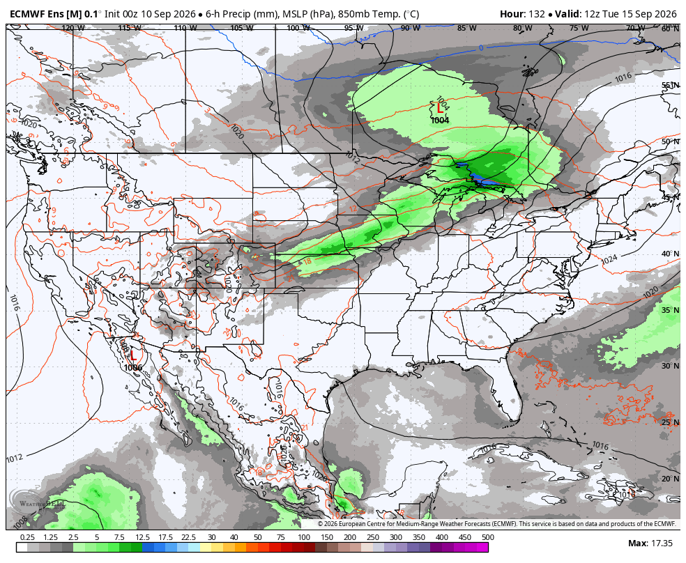
Figure 4. Projected precipitation totals between midnight and 6 AM on Tuesday.
Wet last half of week in eastern Nebraska
Upper-level ridging is likely to be in place over the southeastern U.S. in the middle and latter portions of next week. This will keep that region hot and dry and it will be putting the eastern side of the state in a favorable area for ridge riders. Multiple shortwaves will be coming in from the northwest, which will lead to regular chances for showers and storms in the central Plains and western Corn Belt between Wednesday and Saturday.

Figure 5. Projected 500-mb anomalies on Wednesday
Rainfall rates may be excessive at times and there is a growing probability of 2" of rain falling between Sunday and Saturday. ECMWF ensemble probabilities show a reasonable chance of 4"+ of rain in the southeast part of the state between David City and Rulo. Wouldn't shock me if parts if southeast Nebraska, northeast Kansas, northwest Missouri, and western Iowa got over 6" of rain next week. Flash flooding may be an increasing risk later in the week in the southeast quadrant of the state.

Figure 6. ECMWF ensemble probability of 2"+ of rain next week
There will likely be a fairly sharp cutoff in totals next week in central or west central Nebraska, with areas to the west likely not getting much rain after Tuesday. Temperatures next week will be cooler than they have been of late, especially in the eastern half of the state during the afternoons. No truly chilly nights are likely next week outside of the highest elevations in the Panhandle. The CPC's 8-14 day outlook shows warmer than average favored in the western and southern U.S. There is some indication that troughing in the eastern U.S. may be more prominent by the Equinox, which would possibly keep eastern Nebraska a bit cooler than average.
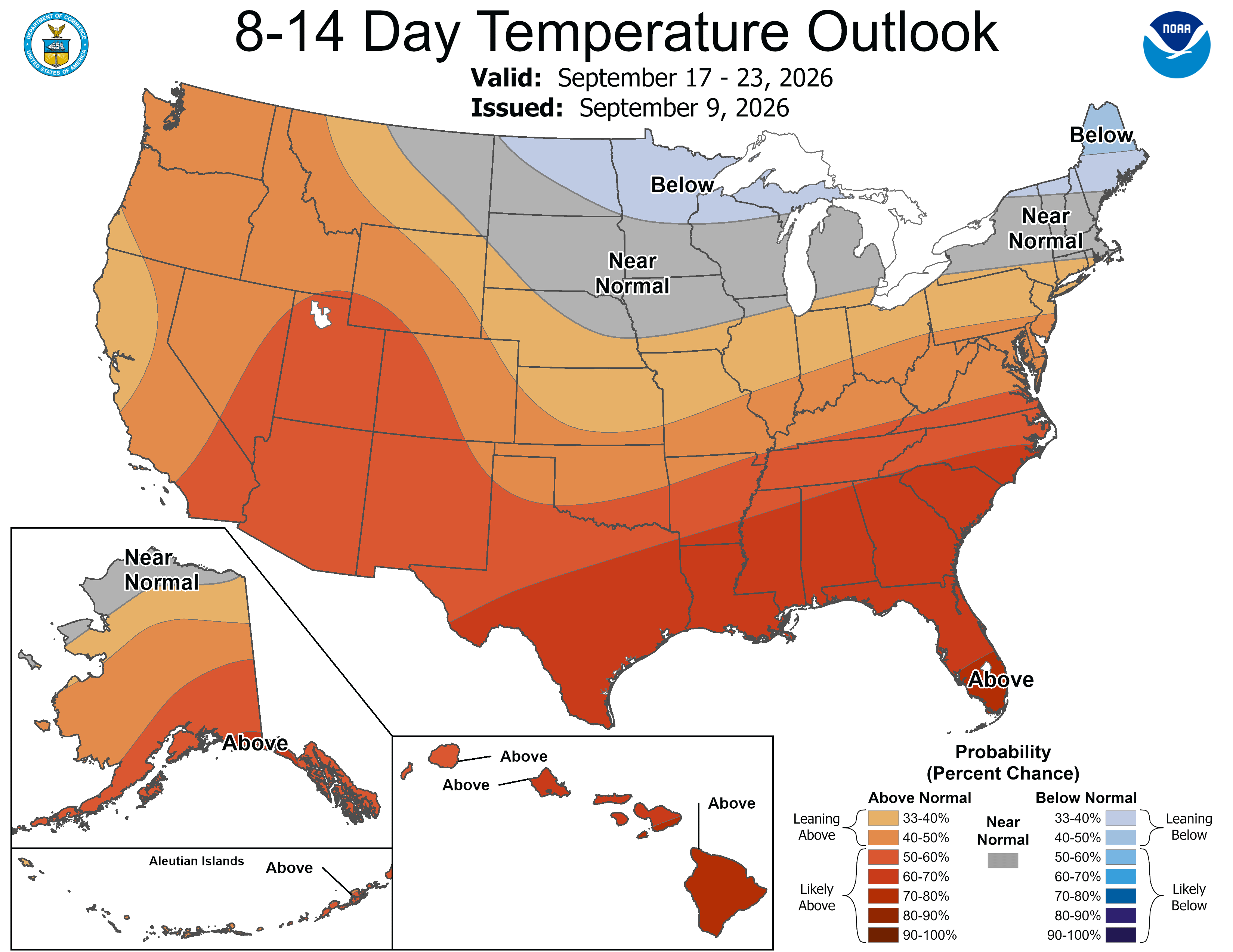
Figure 7. CPC's 8-14 day outlook

