
A potentially historic El Niño is developing in the Tropical Pacific Ocean. What could it mean for Nebraska?
El Niño starts thousands of miles from Nebraska, in the tropical Pacific. Changes in that part of the ocean can shift weather patterns around the world. For Nebraska, El Niño can tilt the odds toward some seasonal temperature and precipitation patterns, but it can’t tell us what will happen in every storm, month, or part of the state.

What is happening in the Pacific?
El Niño is now well established. The map below shows a broad area of unusually warm water along the equator, with the strongest relative warmth in the eastern Pacific.
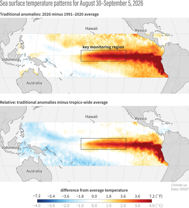
Figure 1. Relative sea surface temperature anomalies at the end of August.
El Niño isn’t going anywhere soon.
The chance that El Niño continues through February 2027 is nearly 100%. This is the highest level of certainty in the World Meteorological Organization’s 50-year history.
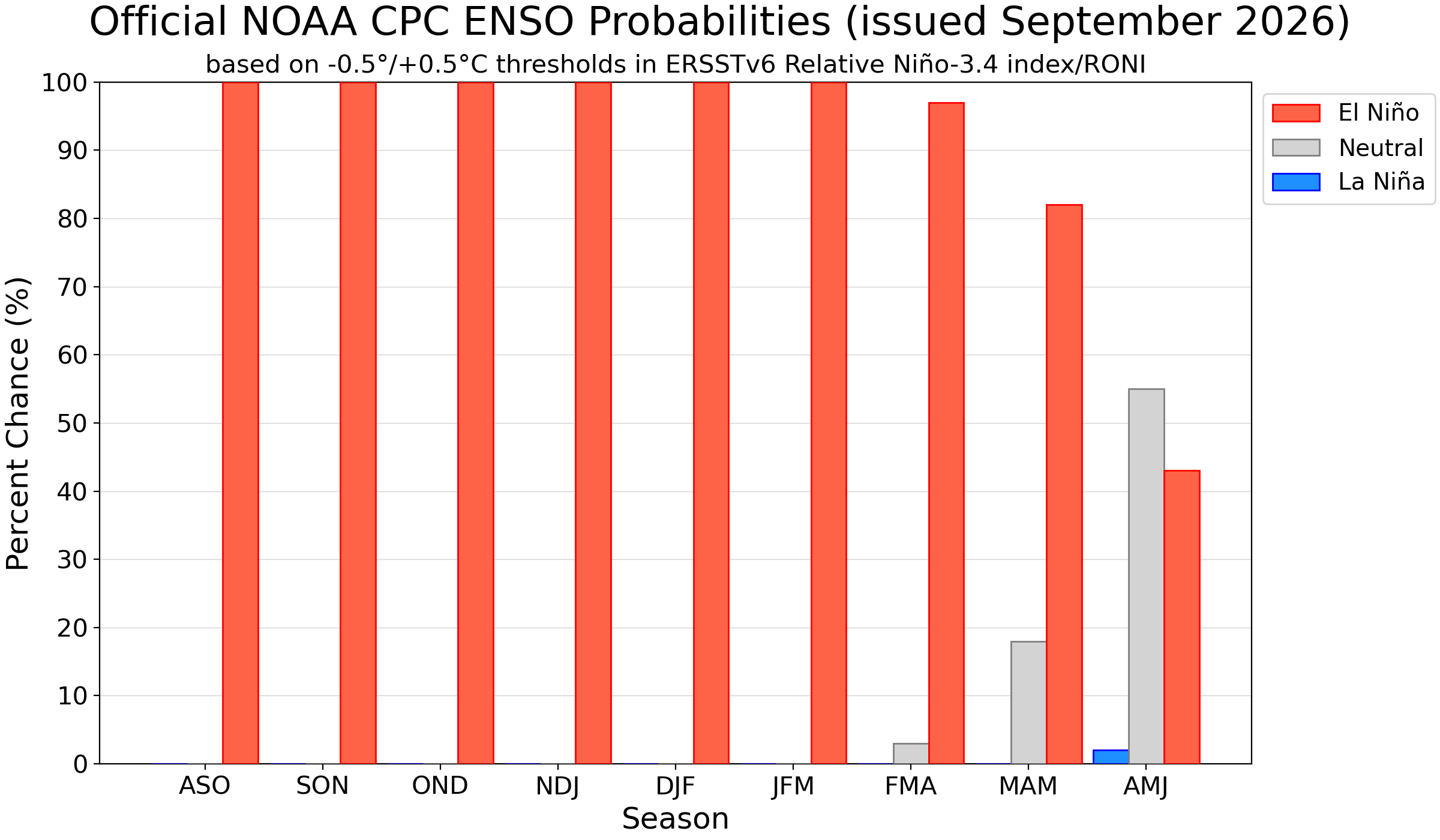
Figure 2. Bar chart showing ENSO probabilities for seasons; El Niño dominates, with small Neutral and La Niña chances.
RONI? What’s that?
Scientists need a way to keep track of El Niño as it grows and fades. NOAA now uses the Relative Oceanic Niño Index, or RONI, to measure its strength. RONI compares how warm the El Niño region of the Pacific is to the surrounding tropical ocean. That matters because the tropical oceans themselves have warmed. Accounting for that background warming gives us a better way to compare El Niños across different years. Once RONI reaches +0.5°C, we’re in El Niño territory. Higher RONI values indicate a stronger ocean temperature signal. RONI is reported as a three-month average. OND means October–November–December, and so on.
So, how unusual is this El Niño?
Potentially very unusual. At this point in its development, 2026 is tracking close to some of the strongest El Niños in the historical record NOAA now gives it a 75% change of reaching a RONI of +2.5°C or higher this fall, a level not reached by any previous event in the RONI record.
The table compares 2026 with several past strong El Niños at the same stage of development. One important difference: the 2026 peak is still a forecast. We don’t know yet how strong this event will ultimately become.
| Event | RONI in OND | Peak RONI | Peak Season |
| 1982-1983 | +2.2°C | +2.4°C | NDJ/DJF |
| 1997-1998 | +2.3°C | +2.3°C | OND/NDL |
| 2015-2016 | +2.2°C | +2.3°C | NDJ/DJF |
| 2026-2027 | +2.67°C forecast | +2.67°C forecast | OND forecast |
Table 1. RONI values in previous very strong El Ninos
So, what does this mean for Nebraska?
What El Niño means for Nebraska isn’t always straightforward. We often fall within a transition zone between stronger climate signals to our north and south. That can make our seasonal outlook less straightforward.
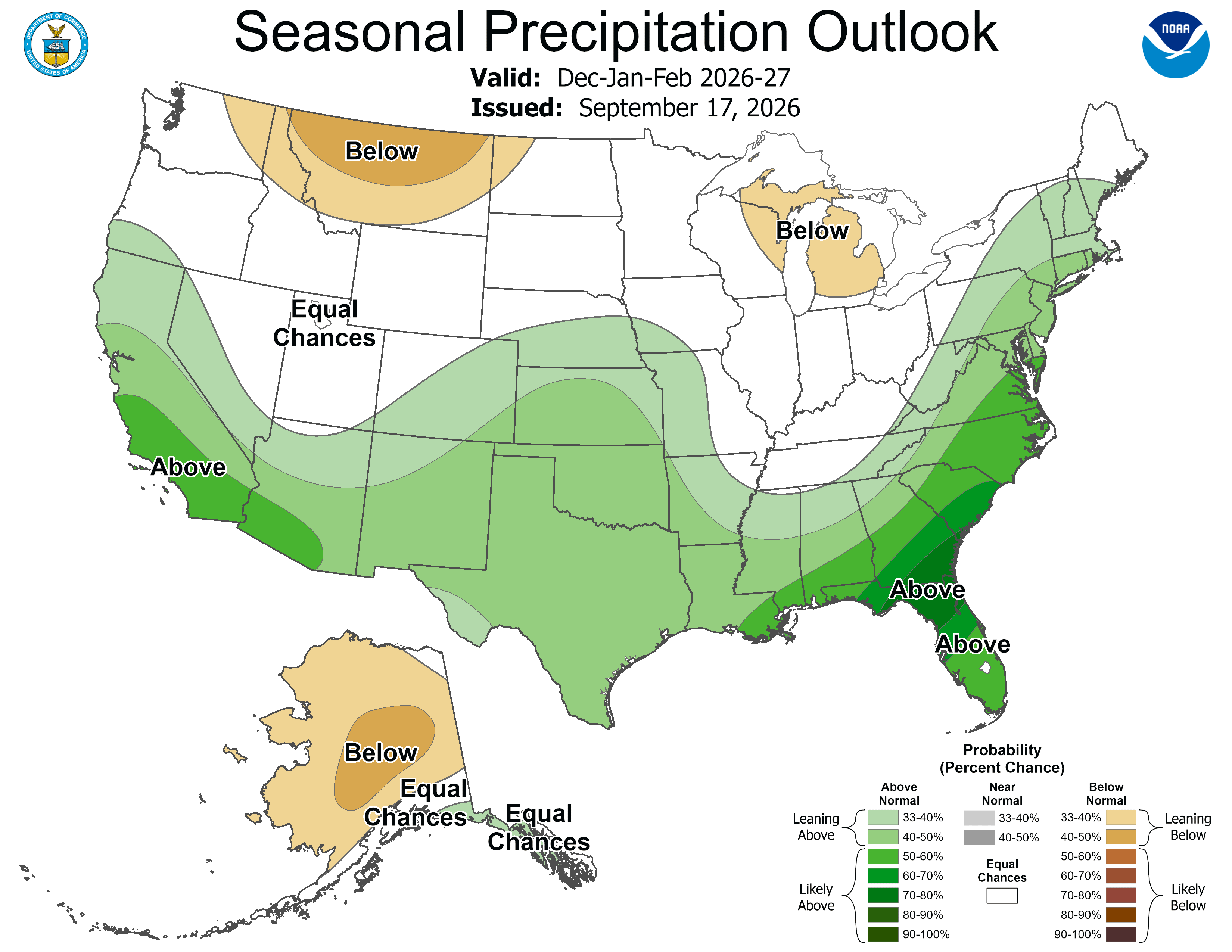
Figure 3. Climate Prediction Center's precipitation outlook for December-February
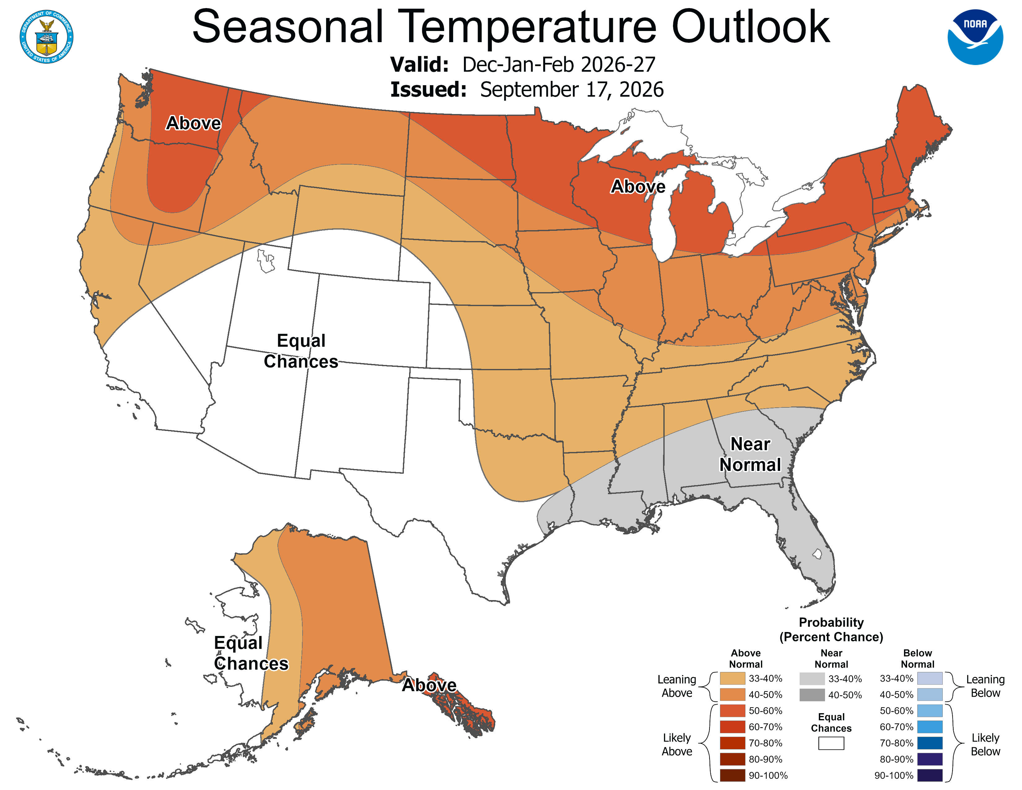
Figure 4. Figure 3. Climate Prediction Center's temperature outlook for December-February
Nebraska this winter
For now, the winter leans warm. Above-normal temperatures are favored across Nebraska. Southern Nebraska leans wetter. Farther north, no precipitation category is favored. El Niño-related late-fall precipitation could improve drought conditions. Darker colors mean a higher probability, not how much warmer, colder, wetter, or drier conditions might be. Equal Chances means none of the categories is favored. El Niño has a stronger, more consistent influence on Nebraska in winter than in fall.
What have past strong El Niño events meant for Nebraska?
Past strong El Niño winters provide useful context for 2026–27, but they haven’t all looked the same.
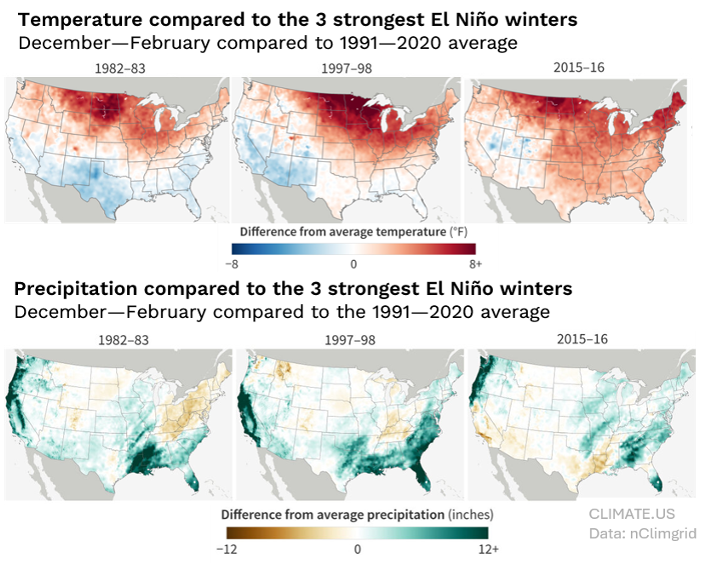
Figure 5. Temperature and precipitation composite for the past three very strong El Ninos
Temperature shows a clearer pattern than precipitation. El Niño winters were often warmer across Nebraska and the northern U.S., while precipitation varied considerably from one event to another.
Past strong El Niños provide context, not a forecast for 2026–27.
KEY MESSAGE: El Niño shifts the odds. It doesn’t determine Nebraska's Winter.
Learn more and follow updates: NOAA CPC ENSO Updates | NOAA CPC Seasonal Outlooks | NOAA CPC RONI | WMO El Niño/La Niña Updates |Nebraska State Climate Office.


