
What is a front?
A front is simply a boundary of warmer air versus colder air. A cold front replaces warmer air and a warm front replaces colder air. There is also a difference in air density, with less dense air and lower pressure after a warm frontal passage. An example of a strong spring cold front from March 2025 is shown below in Figure 1.
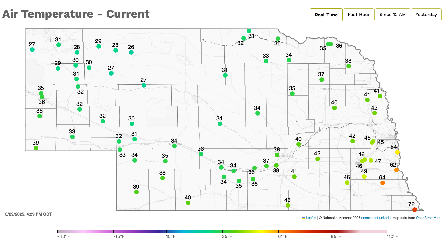
Figure 1. Nebraska Mesonet sites on the afternoon of March 29, 2025
General rules of thumb with warm and cold fronts
| Frontal type | Temperature | Winds | Pressure |
| Cold | Falling | N-NW | Rising |
| Warm | Rising | S | Falling |
What is the pressure gradient force?
Before we get much further into this topic, I want to discuss the pressure gradient force a bit more. It is simply the difference in pressure in a fluid. Air moves from higher pressure to lower pressure. The more relaxed the pressure gradient is, the lighter the wind speeds. The more intense the pressure gradient is, the stronger the wind speeds. A great example of this is the nor'easter off the East Coast of the U.S. over the weekend.

Figure 2. Wind speeds this past Saturday morning.
What is the jet stream?
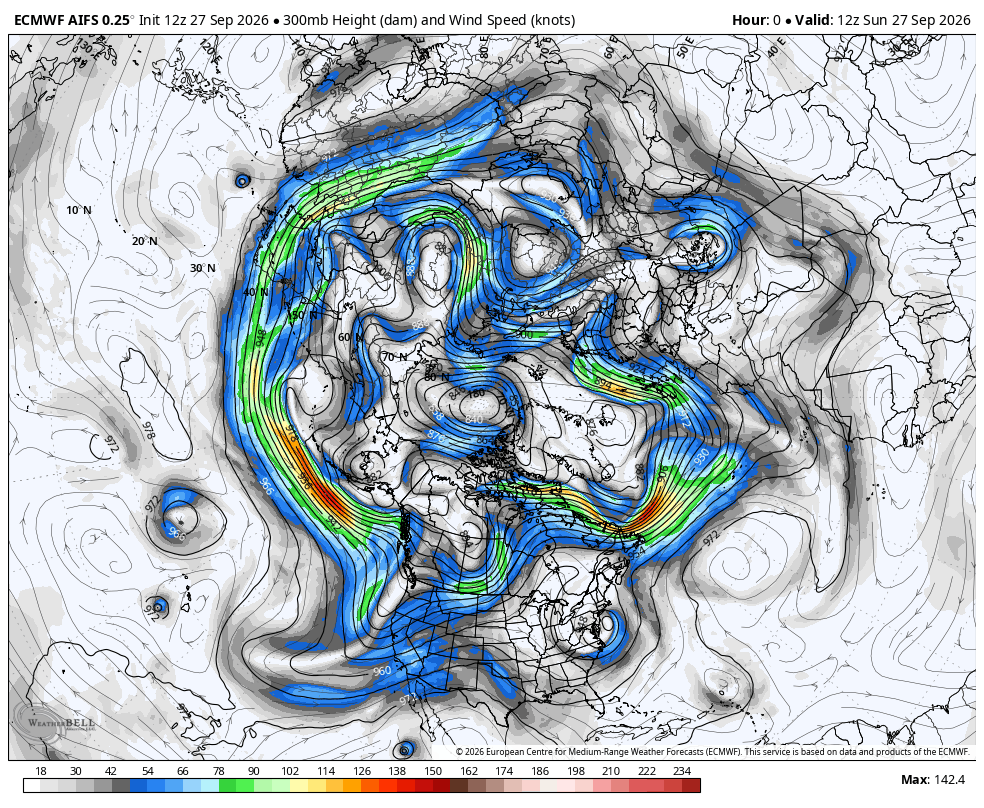
Figure 3. 300-mb wind speeds on Sunday
The American Meteorological Society defines the jet stream as follows: "Relatively strong winds concentrated within a narrow stream in the atmosphere.
While this term may be applied to any such stream regardless of direction (including vertical), it is coming more and more to mean only a quasi-horizontal jet stream of maximum winds embedded in the midlatitude westerlies, and concentrated in the high troposphere. The question of the maintenance of the jet stream is a cardinal problem of theoretical meteorology. Two such jet streams are sometimes distinguished. The predominant one, the polar-front jet stream, is associated with the polar front of middle and upper-middle latitudes. Very loosely, it may be said to extend around the hemisphere, but, like the polar front, it is discontinuous and varies greatly from day to day. A subtropical jet stream is found, at some longitudes, between 20° and 30° latitude and is strongest off the Asian coast. Currently, in the analysis of upper-level charts, a jet stream is indicated wherever it is reliably determined that the wind speed equals or exceeds 50 knots."
Thermal wind
Jet streams are driven by temperature gradients, because of the thermal wind relationship. The thermal wind states that the geostrophic wind speeds increase with a vertical increase in wind shear, which is related to a stronger pressure gradient force.
In English, this means that jet streams are going to be strongest when and where temperature gradients are larger. Check out where the stronger wind speeds are in Figure 3 compared to the strongest temperature gradients in Figure 4.
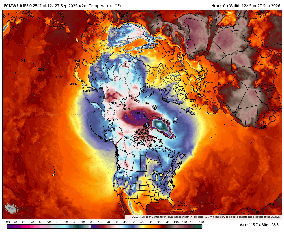
Figure 4. Temperatures on Sunday morning
The polar jet shifts south in the Northern Hemisphere winter as the higher latitudes are colder and lifts poleward in the summer. Climate change is affecting the placement and the strength of the jet stream.


