
Act 1: Rain
A look at upper-air analysis shows a ridge over central Texas with copious Gulf moisture coming up and around the ridge. An enhanced subtropical jet nosing into the southwestern U.S. is bringing in Pacific moisture and helping generate a broad area of atmospheric rising motion throughout the Plains.
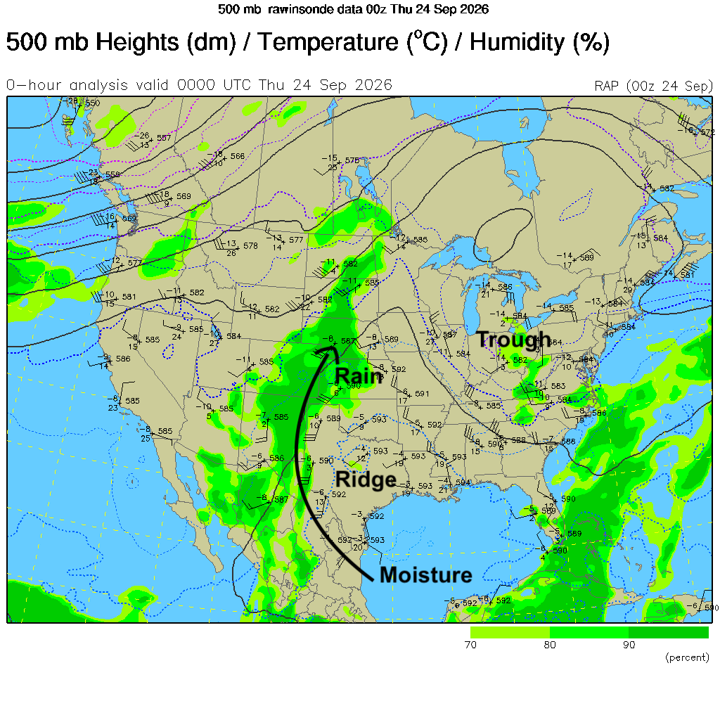
Figure 1. 500-mb map from yesterday evening
Rain has been falling most of the day in west central and central Nebraska and rain will continue on a semi-regular basis for the next 12-18 hours for most of central and eastern Nebraska. There should be some breaks tomorrow morning but additional showers and storms will move in from the south tomorrow afternoon/evening through Saturday midday. Rainfall totals in excess of 2" will be likely in much of eastern Nebraska with an inch to two inches likely in south central Nebraska. Flash flooding will be possible Friday evening in eastern sections if there are heavier periods of rain but in general, the rates should be gentle enough to keep the flash flooding risk lower. Amounts will drop off quickly northwest of Kearney.
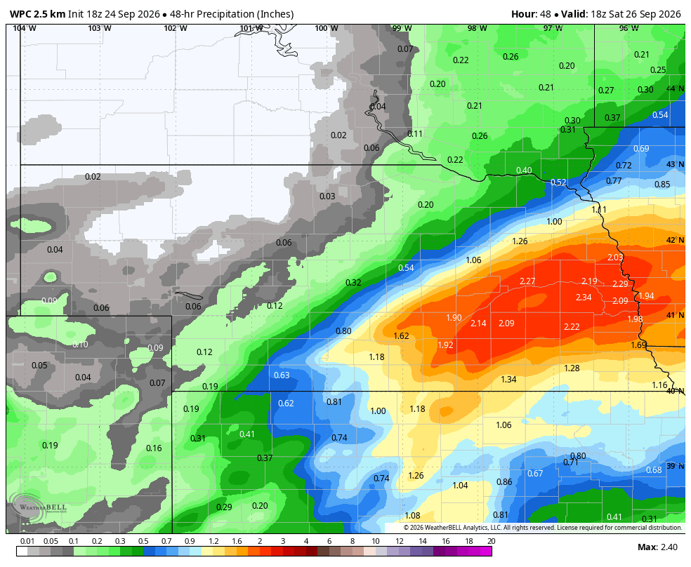
Figure 2. Projected precipitation totals through Saturday
Intermission
Rain should exit eastern Nebraska by Saturday evening and Sunday should be dry statewide. Temperatures should be in the 70's (east and central) and in the 80's in the Panhandle where sunshine will be most abundant. Clouds may be stubborn in eastern sections but everyone should see some sun on Sunday afternoon.

Figure 3. Projected high temperatures on Sunday
Act II: Heavy rain
By late Monday a trough will move into the southwestern U.S. and will slowly eject out into the central Plains through mid-week and a surface low will likely develop in southeast Colorado and move northeast into our area. This storm system will have plenty of moisture to work with thanks to Gulf access and Hurricane Polo and enough dynamics to generate significant rainfall in the central Plains and western Corn Belt.

Figure 4. Projected 500-mb anomalies on Monday evening
Exactly how fast this storm progresses is a little in question but right now it appears that western Nebraska will have good chances for moisture on Monday night into Tuesday and the central and eastern sections will have a prolonged periods of rain and embedded storms between Tuesday morning and Thursday morning.
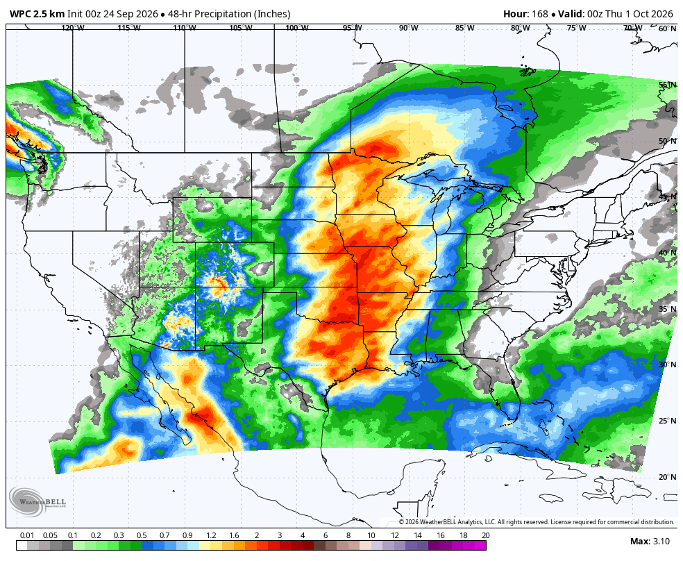
Figure 5. WPC projected rainfall totals between Monday night and Wednesday night
Total rainfall will likely be under a half inch in the Panhandle (where we need it most), a half inch to inch and a half in west central Nebraska, 1-3" in central Nebraska, and 2-4" in eastern Nebraska. Wouldn't surprise me if some locations in eastern Nebraska and into Iowa got an additional 5" of rain. Will need to carefully monitor this situation for possible flooding in eastern sections of Nebraska next week.
By the time next Wednesday is closed, it is likely that some locations will have had their wettest September on record. Quite the change from recent years where mid-to-late September precipitation has been mostly non-existent. The good news is that many areas will have a full profile of moisture going into October and drought will continue to get eradicated in central and northeast Nebraska. The bad news is this weather will likely sideline harvest work for a while.
Dry October?
Models are advertising ridging developing over the northern Rockies in early October as a split jet sends stronger flow well into Canada and weaker flow into the southern U.S. This would bring a brief taste of cooler temperatures in early October. More importantly this pattern would bring much drier weather into the region.
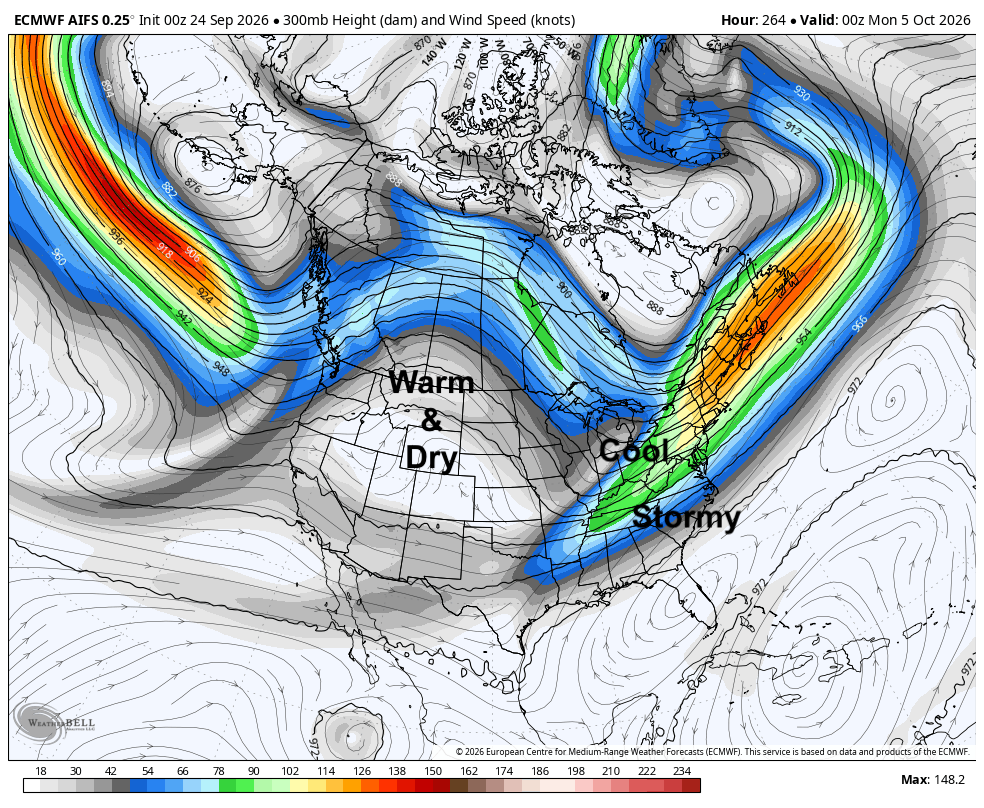
Figure 6. Projected 300-mb map for October 5th.
The ECMWF ensemble shows drier than average conditions favored in the first part of October and there is some signal that this drier signal may persist through much of the first half of October. Warmer than average temperatures are likely statewide between October 6-15th. In other words, I am getting cautiously optimistic a decent harvest window will open up next month. Here's to hoping!

Figure 7. ECMWF ensemble's projected rainfall anomalies in the week ending October 8th.


