
Hot weekend ahead
Temperatures across the state are generally in the 70's but those numbers will be going up soon. Seasonally cool temperatures will persist across eastern Nebraska tomorrow but the heat will be back for the western half of the state. Highs may flirt with 100°F around Chadron. The heat will spread east into the weekend with temperatures ranging from the upper 80's (northeast Nebraska) and lower 90's (southeast and south central) to the mid 90's (eastern Sand Hills) and lower 100's (Panhandle). There will be chances for showers and storms in the eastern part of the state on Sunday. But in general, the state will be dry between tomorrow and early next week.

Figure 1. Projected high temperatures on Sunday
Cold front
A cold front likely will work its way through the state by Tuesday, which will shift the winds back to the north and east and bring somewhat cooler temperatures back. Highs likely will be in the mid 80's in eastern Nebraska, 85-90°F in central Nebraska, and lower to mid 90's in western Nebraska. The western side of the state should cool off even more by Wednesday. It appears that the nights will remain warmer than average for much of next week but daytime highs should be mostly in the 80's. Some days may be even cooler than that if cloud cover and precipitation are prominent. Humidity will be elevated next week across the state, which may be favorable to some fungal diseases.

Figure 2. Projected 500-mb height anomalies next Tuesday
Storms
There will be some chances of storms with the frontal passage. But the best chance of showers and storms looks to be in the back half of the week when a few shortwaves come around the top of the ridge. This will open up good chances for showers and storms starting late Wednesday into Thursday and continuing through the remainder of the week. Precipitation amounts are hard to pin down this far out but it seems reasonable that some areas will get over an inch in the back half of the week.

Figure 3. 500-mb heights with areas of vorticity
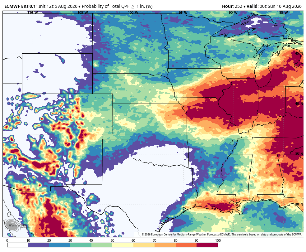
Figure 4. Probability of 1" or more of rain through next Saturday
With the ridge likely to persist across the south central of the U.S. deeper through the middle of August, Nebraska will remain in a favorable area for ridge riding storms through the week after next. The CPC has the entire state (and most of the U.S. outside the south central region) as being favored for wetter than average conditions in the 8-14 day period. Furthermore, the ECMWF shows above average rainfall in the 7-day period ending August 18th for all of Nebraska. This also would suggest potential for significant precipitation from the southwest and southern Rockies into the central Appalachians.
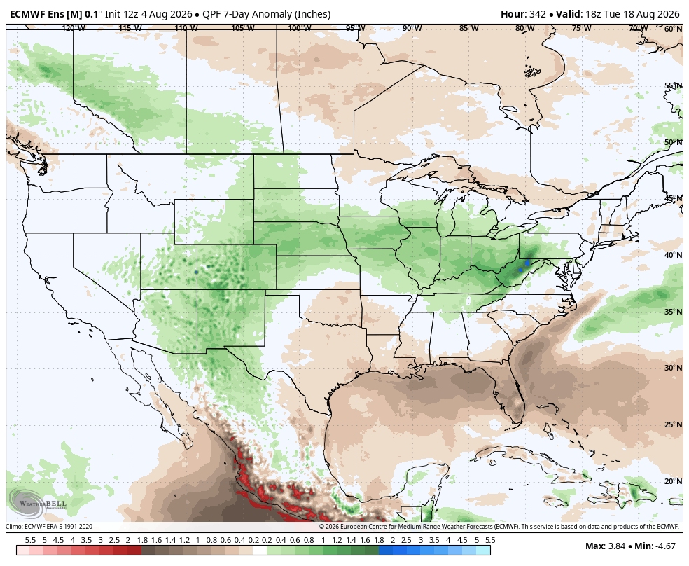
Figure 5. ECMWF projected 7-day precipitation anomalies ending August 18th
Heat remaining south?
Temperatures likely will be warming back into above average territory eventually but the period between August 14-18 likely will see the heat anchored across the southern Plains as the ridge stays anchored down there. This is bad news for the rapidly intensifying drought down there but our area likely will be just to the north of the hottest air. I expect the heat to still pulse in and out through at least the end of the August but no sustained stretches of extreme heat are likely in the next two weeks anywhere in the Corn Belt.
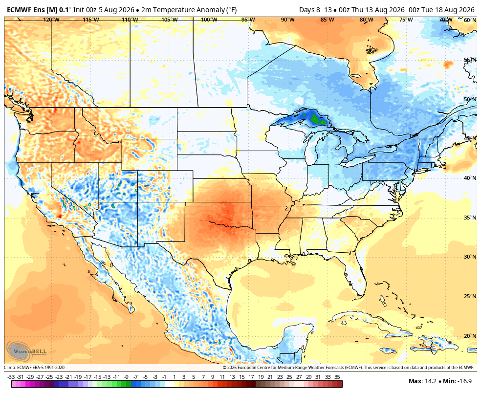
Figure 6. ECMWF ensemble projected temperature anomalies between August 13-17.


