
Hello NCSO, community, and happy Monday. As we near the end of the month here in April, there has been quite a bit in regard to weather, and hazards experienced in the state. I will be covering this in my March monthly climate summary if you would like to take a read. The article will be posted toward the latter half of the week, if I am able to stay on track with tying in some remaining features for the discussion. For Nebraska, this past week showed a pronounced warming trend early, followed by increasing variability in both moisture and temperature. Highs climbed well into the 80s across much of the state, including Omaha, Kearney, North Platte, and O’Neill areas, with slightly cooler readings toward Scottsbluff and Valentine in the north and northeast. Despite the warmth, humidity values dropped sharply, particularly across western and central Nebraska, where relative humidity frequently fell into the 10–30% range, contributing to widespread Red Flag Warnings and elevated fire danger concerns. Precipitation remained limited early in the period, with only isolated sprinkles or light showers reported, though thunderstorm chances increased later in the week, especially across eastern Nebraska.
From a synoptic perspective, the week was dominated by southwesterly flow aloft ahead of a western U.S. trough, supporting warm air advection and dry conditions early on. At the surface, a leeside low developed over the High Plains, helping to establish a dryline across central Nebraska and later a warm front lifting northward into eastern portions of the state. At 850 mb, warm air and modest moisture return contributed to instability, particularly ahead of the boundary. By 500 mb, an approaching trough from the Four Corners region enhanced lift midweek, while a 300 mb jet structure provided additional upper-level support for developing convection, especially Tuesday and Friday when severe potential increased.
Some systems influenced Nebraska’s weather this week. A dryline passage early in the week led to sharp drops in humidity and increased fire weather concerns, particularly west of Kearney and North Platte. A warm front near the Nebraska–Kansas border became the focal point for thunderstorm development Tuesday, separating cooler, more stable air to the north from warmer, unstable air to the south. Later in the week, a strong cold front associated with a deepening low-pressure system moved through Friday into Saturday, bringing a shift to cooler conditions and the potential for widespread precipitation. Some areas also experienced weak shortwave disturbances embedded in the flow, contributing to scattered showers and isolated storms.
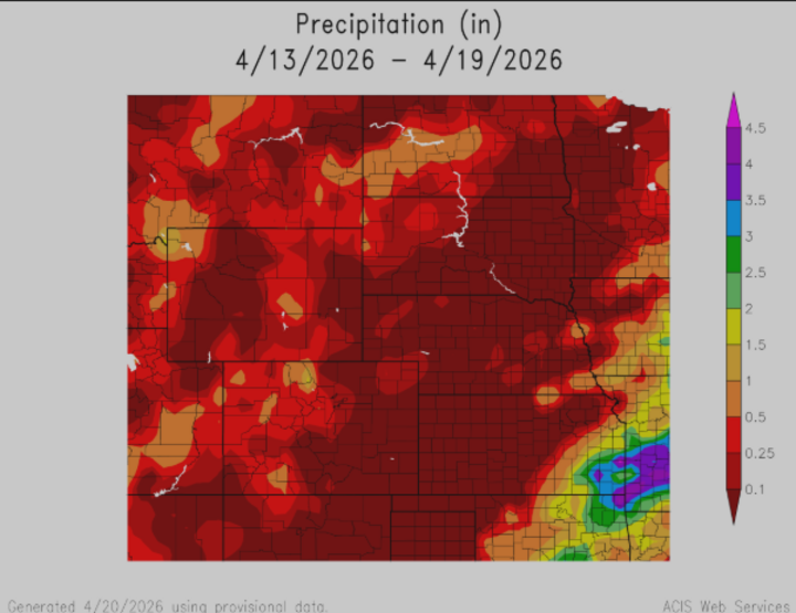
Precipitation across the state was generally limited and uneven, with the best chances occurring Tuesday night through Wednesday and again late Friday into Saturday. Northern and central Nebraska, including areas near Valentine and O’Neill, had better chances of measurable rainfall, though amounts were often light and not widespread. Eastern Nebraska, including Omaha, saw higher potential for strong to severe thunderstorms, with hazards including hail and gusty winds. Western Nebraska, including Scottsbluff and North Platte, remained relatively dry for much of the week, with precipitation largely tied to frontal passages later in the period.
Temperature and Precipitation Extremes:
Maximum High Temperature: Mid to upper 80s°F, widespread across central and eastern Nebraska
Minimum High Temperature: Upper 50s to low 60s°F, western Nebraska late in the week
Minimum Low Temperature: Mid 20s to low 30s°F, northern Nebraska over the weekend
Maximum Low Temperature: Upper 50s to near 60°F, eastern Nebraska early in the week
Maximum Precipitation: Around 0.25"+, primarily north of I-80 and into the Sandhills region
To wrap things up, this week showcased a transition pattern across Nebraska, starting warm, dry, and fire-prone, and into a more active setup with thunderstorms and a late-week trend toward cooler temperatures. Looking ahead, we should expect cooler temperatures in the 50s and 60s with the potential for frost or freeze conditions through the rest of today into tomorrow morning, especially in northern areas. Fire weather concerns may ease slightly with the cooler conditions, but wind and low humidity could still pose localized risks. Additionally, another round of strong to severe storms remains possible late in the week, so please be sure to pay attention to the weather toward Thursday and Friday!


