
Hello NSCO, community, and new readers! As we are near the end of April, things are beginning to feel a bit more like spring, with warmer temperatures, and blooming flowers and trees. However, keep in mind, we won’t be hitting early summer temperatures this week given the past week’s weather, which we will dig into below!
This past week across Nebraska featured a pronounced warming trend following a cooler start, with early morning lows dipping into the 30s across portions of the state, especially near in the northeast, north central, and northwest portions of the state between Valentine and O’Neill, before a rapid transition occurred with warmer temperatures by Monday and Tuesday. Afternoon highs climbed into the upper 70s and 80s statewide, with localized low 90s developing across southwest Nebraska near North Platte and Scottsbluff. Despite the warming, conditions remained notably dry, with low relative humidity values frequently dropping into the teens and even single digits across western Nebraska. Omaha and eastern Nebraska saw slightly higher moisture at times but still remained relatively dry overall. Fire weather has still been a major issue, with widespread Red Flag Warnings issued across central and western Nebraska due to gusty winds and critically low humidity, particularly impacting areas like Kearney and North Platte.
From a synoptic standpoint, the pattern was driven by a transition from an exiting longwave trough over eastern Canada to a building upper-level ridge across the Great Plains supporting those higher temperatures. At the surface, high pressure shifted eastward early in the period, allowing southerly flow to return and promote strong warm air advection. At 850 mb, temperatures surged into the low to mid 60s °F by midweek, supporting surface highs well into the 80s and low 90s. By 500 mb, ridging dominated early, but a developing trough over the western United States, began to eject shortwave energy into the Plains by Wednesday. At 300 mb, increasing jet support and a strengthening low-level jet, reaching 45–55 knots overnight, helped enhance moisture return and set the stage for midweek convection. This evolving vertical structure supported both the warming trend and the eventual transition toward a more active pattern.
Surface features played a major role in the week’s evolution. A persistent lee trough developed along the High Plains, tightening the pressure gradient and producing strong southerly winds across much of the state, especially Wednesday where gusts reached 35–45 mph. A dryline sharpened across western Nebraska, roughly near the Highway 83 corridor, separating very dry air to the west from increasing Gulf moisture to the east. This boundary became the focus for potential thunderstorm development late Wednesday into Thursday. A cold front associated with a deepening surface low over the Dakotas pushed through the state by Thursday into Friday, bringing a shift to cooler and drier conditions. While gravity wave activity was not explicitly highlighted, the strong mixing and dryline circulation suggested a highly dynamic boundary layer environment supportive of fire weather and possible high-based convection.
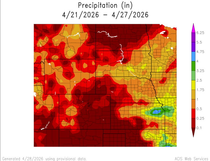
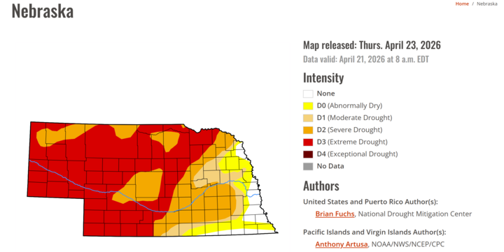
Precipitation across Nebraska was limited for much of the week, with most areas remaining dry through Tuesday. This can be further highlighted by the map showcasing precipitation trends. This backs the risks given by the the NWS for red flag warnings in the western protion of the state. By Wednesday night into Thursday, scattered showers and thunderstorms began to develop, primarily impacting eastern Nebraska near Omaha and areas east of Highway 81. Western Nebraska, including Scottsbluff and North Platte, saw little to no precipitation due to dry air west of the dryline. Overall precipitation amounts remained light and spotty, with many locations receiving minimal accumulation. The primary impact was not rainfall but rather its absence, which contributed to elevated fire weather concerns across nearly the entire state. Another map that would show how much western Nebraska is in need of precipitation would be the Drought Monitor, which shows that much of the western half of the state is in a moderate drought.
Temperature and Precipitation Roundup:
| Station | Omaha | Lincoln | Norfolk | Grand Island | North Platte | Valentine | Scottsbluff |
| Average High Temperature (°F) | 76.5 | 78.3 | 74.7 | 77.0 | 76.0 | 71.9 | 72.0 |
| Average Low Temperature (°F) | 46.7 | 46.1 | 40.9 | 42.3 | 32.6 | 34.6 | 34.4 |
| Average Temperature (°F) | 61.6 | 62.2 | 57.8 | 59.6 | 54.3 | 53.2 | 53.2 |
| Maximum Temperature (°F) | 88 | 89 | 90 | 90 | 91 | 93 | 89 |
| Minimum Temperature (°F) | 35 | 33 | 31 | 33 | 18 | 27 | 19 |
| Total Precipitation (in.) | 0.67 | 0.73 | 0.40 | 0.58 | 0.00 | 0.42 | 0.08 |
| Total Snowfall (in.) | 0.0 | 0.0 | 0.0 | 0.0 | 0.0 | 0.1 | 0.0 |
| Total Heating Degree Days | 38 | 33 | 59 | 43 | 77 | 86 | 87 |
| Total Cooling Degree Days | 17 | 16 | 11 | 8 | 5 | 6 | 5 |
Looking ahead into the next week, Nebraska is expected to transition into a cooler pattern. Behind the cold front, temperatures will drop back into the 60s by Friday and even into the 50s and low 60s over the weekend. Additional shortwave troughs moving through the broader longwave trough over the western CONUS will bring periodic chances for showers and thunderstorms statewide. There is also some indication of a stronger system developing over the weekend, potentially bringing more widespread precipitation, and even the possibility of wet snow mixing across northern Nebraska, particularly near Valentine. Fire weather concerns may briefly diminish with cooler temperatures and higher humidity, but gusty winds and dry fuels could still pose localized risks. Overall, the pattern shift suggests a move away from extreme fire danger toward a more unsettled and seasonably cool regime.


